

There are many challenges in the application of SAR data in flood mapping which
includes mountain shadows, wind effect on open water, double bounce effect, and
corner reflection (Fig. 16.3). The amount of backscatter is widely influenced by the
roughness of the surface. Therefore, it is hard to separate water bodies when the
water surface is disturbed by the wind, streamflow, and turbulence. The flood
mapping with SAR data is also challenging in the vegetated and agricultural areas
because of the double bounce effect. Due to the double bounce effect, the flooded
forest returns more backscatter than the non-flooded forest in the SAR reading.
Flood mapping in cropland might face similar challenges when crops are not entirely
underwater. A longer wavelength microwave (P-band) might be useful for flood
mapping in the vegetated area due to its capability to penetrate the canopy. Flood
mapping with SAR data might also be challenging in urban areas due to backscattering from corner reflection. Regions with mountain shadows and flooded areas
appear dark in SAR images which also limits the application of SAR data for flood
mapping in the mountain area. A combined approach of SAR and optical data might
improve the performance of flood mapping in the mountain area (Yang et al. 1999).
The success of flood mapping with SAR data might also depend on other factors
such as wavelength, incident angle, and polarization. For instance, Hess et al. (1995)
found that like polarization (HH, VV) is suitable for flood mapping in swamps area,
whereas cross-polarization (HV, VH) is appropriate for marsh area.
There are many scopes for the improvement of remote sensing-based flood
monitoring. Many systems like Remote Sensing based Flood Crop Loss Assessment
(RF-CLASS) require frequent flood mapping (Di et al. 2013). Since many crops can
be completely damaged within 2–3 days of flood, RF-CLASS needs to capture these
short-termed floods in near real-time. The question is can current remote sensing
capability meet up that requirement? The answer might be partially a yes because
coarse resolution optical missions (e.g., MODIS and AVHRR) have the short revisit
capabilities to monitor the short-lived flood. However, the inability to sense through
the cloud and coarse spatial resolution make them incapable of reliable flood
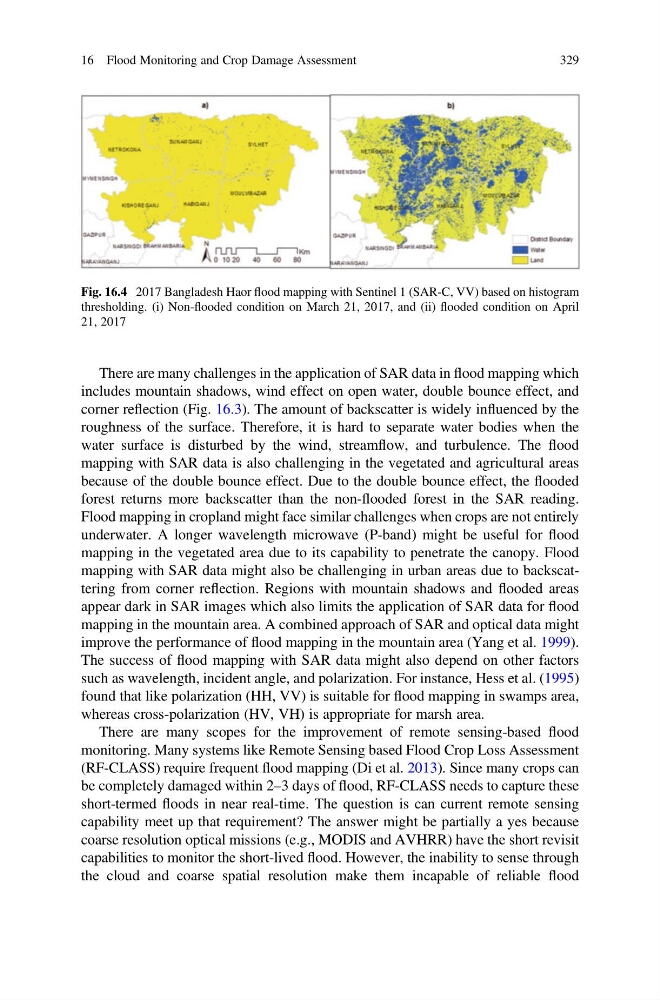
Fig. 16.4 2017 Bangladesh Haor flood mapping with Sentinel 1 (SAR-C, VV) based on histogram
thresholding. (i) Non-flooded condition on March 21, 2017, and (ii) flooded condition on April
21, 2017
16 Flood Monitoring and Crop Damage Assessment
329
includes mountain shadows, wind effect on open water, double bounce effect, and
corner reflection (Fig. 16.3). The amount of backscatter is widely influenced by the
roughness of the surface. Therefore, it is hard to separate water bodies when the
water surface is disturbed by the wind, streamflow, and turbulence. The flood
mapping with SAR data is also challenging in the vegetated and agricultural areas
because of the double bounce effect. Due to the double bounce effect, the flooded
forest returns more backscatter than the non-flooded forest in the SAR reading.
Flood mapping in cropland might face similar challenges when crops are not entirely
underwater. A longer wavelength microwave (P-band) might be useful for flood
mapping in the vegetated area due to its capability to penetrate the canopy. Flood
mapping with SAR data might also be challenging in urban areas due to backscattering from corner reflection. Regions with mountain shadows and flooded areas
appear dark in SAR images which also limits the application of SAR data for flood
mapping in the mountain area. A combined approach of SAR and optical data might
improve the performance of flood mapping in the mountain area (Yang et al. 1999).
The success of flood mapping with SAR data might also depend on other factors
such as wavelength, incident angle, and polarization. For instance, Hess et al. (1995)
found that like polarization (HH, VV) is suitable for flood mapping in swamps area,
whereas cross-polarization (HV, VH) is appropriate for marsh area.
There are many scopes for the improvement of remote sensing-based flood
monitoring. Many systems like Remote Sensing based Flood Crop Loss Assessment
(RF-CLASS) require frequent flood mapping (Di et al. 2013). Since many crops can
be completely damaged within 2–3 days of flood, RF-CLASS needs to capture these
short-termed floods in near real-time. The question is can current remote sensing
capability meet up that requirement? The answer might be partially a yes because
coarse resolution optical missions (e.g., MODIS and AVHRR) have the short revisit
capabilities to monitor the short-lived flood. However, the inability to sense through
the cloud and coarse spatial resolution make them incapable of reliable flood
Fig. 16.4 2017 Bangladesh Haor flood mapping with Sentinel 1 (SAR-C, VV) based on histogram
thresholding. (i) Non-flooded condition on March 21, 2017, and (ii) flooded condition on April
21, 2017
16 Flood Monitoring and Crop Damage Assessment
329