

Depending on the scale, purpose, and availability of data, the choice of the
sensors and platforms varies. Landsat data archive which offers moderate-resolution
images with global coverage is one of the most popular data in flood mapping.
Coarse spatial resolution (usually greater than 100 m) images derived from Moderate
Resolution Imaging Spectroradiometer (MODIS) and NOAA Advanced Very HighResolution Radiometer (AVHRR) are suitable for regional-scale flood monitoring.
DFO is one of the most known automatic flood detection systems using MODIS data
to provide near-real-time global flood information. Fine spatial resolution data (e.g.,
IKONOS) might be useful for local flood mapping. The application of fine resolution
remote sensing in flood mappings is not efficient due to low ground coverage, long
processing time, and high cost.
There are many challenges in the application of optical remote sensing in flood
monitoring. The most discussed challenge is cloud cover as optical sensors are
unable to take measurements through the cloud cover. Tropical regions usually
have a high cloud cover during the rainy season. There are also strong possibilities
of cloud coverage during storm-induced flood events. Therefore, optical remote
sensing might not be useful for the monitoring of storm-induced floods and floods
in tropical countries. Since both paved area and water reflect low energy in NIR, it is
difficult to discriminate between them. This issue might be crucial in urban flood
mapping, but might not be significant for large area flood mapping. Wang et al.
(2002) found that this problem might be avoided by adding Mid-Infrared (MIR) with
NIR. The low combined value of NIR and MIR indicates water, and a high value
indicates a non-flooded area. Another challenge is the inability of optical energy to
penetrate the tree canopies. Thus, optical remote sensing is not appropriate for flood
mapping under the tree canopy. Hill shadow is also an additional challenge for flood
mapping in a mountainous area. Despite these limitations, optical remote sensing is
widely used for flood monitoring because of its global coverage, availability at free
of cost, and longtime archives.
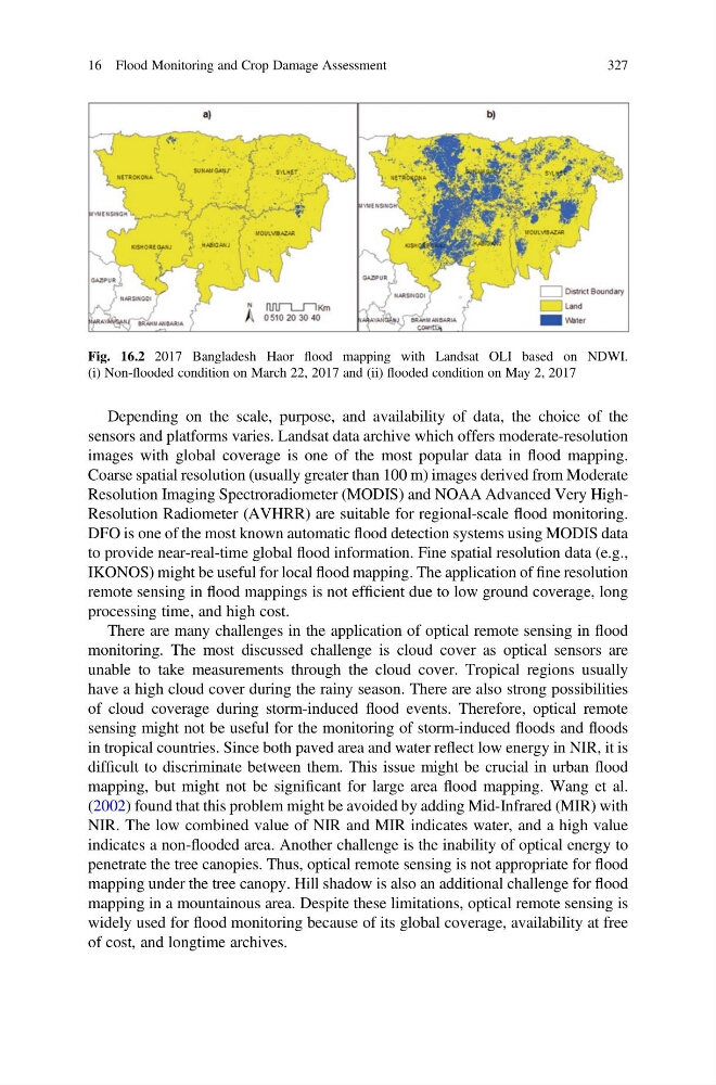
Fig. 16.2 2017 Bangladesh Haor flood mapping with Landsat OLI based on NDWI.
(i) Non-flooded condition on March 22, 2017 and (ii) flooded condition on May 2, 2017
16 Flood Monitoring and Crop Damage Assessment
327
sensors and platforms varies. Landsat data archive which offers moderate-resolution
images with global coverage is one of the most popular data in flood mapping.
Coarse spatial resolution (usually greater than 100 m) images derived from Moderate
Resolution Imaging Spectroradiometer (MODIS) and NOAA Advanced Very HighResolution Radiometer (AVHRR) are suitable for regional-scale flood monitoring.
DFO is one of the most known automatic flood detection systems using MODIS data
to provide near-real-time global flood information. Fine spatial resolution data (e.g.,
IKONOS) might be useful for local flood mapping. The application of fine resolution
remote sensing in flood mappings is not efficient due to low ground coverage, long
processing time, and high cost.
There are many challenges in the application of optical remote sensing in flood
monitoring. The most discussed challenge is cloud cover as optical sensors are
unable to take measurements through the cloud cover. Tropical regions usually
have a high cloud cover during the rainy season. There are also strong possibilities
of cloud coverage during storm-induced flood events. Therefore, optical remote
sensing might not be useful for the monitoring of storm-induced floods and floods
in tropical countries. Since both paved area and water reflect low energy in NIR, it is
difficult to discriminate between them. This issue might be crucial in urban flood
mapping, but might not be significant for large area flood mapping. Wang et al.
(2002) found that this problem might be avoided by adding Mid-Infrared (MIR) with
NIR. The low combined value of NIR and MIR indicates water, and a high value
indicates a non-flooded area. Another challenge is the inability of optical energy to
penetrate the tree canopies. Thus, optical remote sensing is not appropriate for flood
mapping under the tree canopy. Hill shadow is also an additional challenge for flood
mapping in a mountainous area. Despite these limitations, optical remote sensing is
widely used for flood monitoring because of its global coverage, availability at free
of cost, and longtime archives.
Fig. 16.2 2017 Bangladesh Haor flood mapping with Landsat OLI based on NDWI.
(i) Non-flooded condition on March 22, 2017 and (ii) flooded condition on May 2, 2017
16 Flood Monitoring and Crop Damage Assessment
327