

real-time flood extent mapping for a vast geographical area. Both optical and
microwave remote sensing play a crucial role in flood mapping around the world.
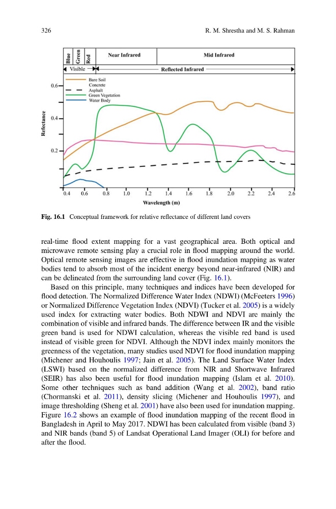
Optical remote sensing images are effective in flood inundation mapping as water
bodies tend to absorb most of the incident energy beyond near-infrared (NIR) and
can be delineated from the surrounding land cover (Fig. 16.1).
Based on this principle, many techniques and indices have been developed for
flood detection. The Normalized Difference Water Index (NDWI) (McFeeters 1996)
or Normalized Difference Vegetation Index (NDVI) (Tucker et al. 2005) is a widely
used index for extracting water bodies. Both NDWI and NDVI are mainly the
combination of visible and infrared bands. The difference between IR and the visible
green band is used for NDWI calculation, whereas the visible red band is used
instead of visible green for NDVI. Although the NDVI index mainly monitors the
greenness of the vegetation, many studies used NDVI for flood inundation mapping
(Michener and Houhoulis 1997; Jain et al. 2005). The Land Surface Water Index
(LSWI) based on the normalized difference from NIR and Shortwave Infrared
(SEIR) has also been useful for flood inundation mapping (Islam et al. 2010).
Some other techniques such as band addition (Wang et al. 2002), band ratio
(Chormanski et al. 2011), density slicing (Michener and Houhoulis 1997), and
image thresholding (Sheng et al. 2001) have also been used for inundation mapping.
Figure 16.2 shows an example of flood inundation mapping of the recent flood in
Bangladesh in April to May 2017. NDWI has been calculated from visible (band 3)
and NIR bands (band 5) of Landsat Operational Land Imager (OLI) for before and
after the flood.
Fig. 16.1 Conceptual framework for relative reflectance of different land covers
326
R. M. Shrestha and M. S. Rahman
microwave remote sensing play a crucial role in flood mapping around the world.
Optical remote sensing images are effective in flood inundation mapping as water
bodies tend to absorb most of the incident energy beyond near-infrared (NIR) and
can be delineated from the surrounding land cover (Fig. 16.1).
Based on this principle, many techniques and indices have been developed for
flood detection. The Normalized Difference Water Index (NDWI) (McFeeters 1996)
or Normalized Difference Vegetation Index (NDVI) (Tucker et al. 2005) is a widely
used index for extracting water bodies. Both NDWI and NDVI are mainly the
combination of visible and infrared bands. The difference between IR and the visible
green band is used for NDWI calculation, whereas the visible red band is used
instead of visible green for NDVI. Although the NDVI index mainly monitors the
greenness of the vegetation, many studies used NDVI for flood inundation mapping
(Michener and Houhoulis 1997; Jain et al. 2005). The Land Surface Water Index
(LSWI) based on the normalized difference from NIR and Shortwave Infrared
(SEIR) has also been useful for flood inundation mapping (Islam et al. 2010).
Some other techniques such as band addition (Wang et al. 2002), band ratio
(Chormanski et al. 2011), density slicing (Michener and Houhoulis 1997), and
image thresholding (Sheng et al. 2001) have also been used for inundation mapping.
Figure 16.2 shows an example of flood inundation mapping of the recent flood in
Bangladesh in April to May 2017. NDWI has been calculated from visible (band 3)
and NIR bands (band 5) of Landsat Operational Land Imager (OLI) for before and
after the flood.
Fig. 16.1 Conceptual framework for relative reflectance of different land covers
326
R. M. Shrestha and M. S. Rahman