

and is known to improve efficiency for statistical sampling and estimation (Cochran
1977). In the construction of a NASS area frame, general cropland (based on
percentage cultivation), agriculture specifically within urban areas, residential/commercial, and non-agriculture are the commonly identified land covers. The strata
completely partition the land area within a state. The agricultural stratum definitions
vary between states depending on the type and intensity of agricultural production.
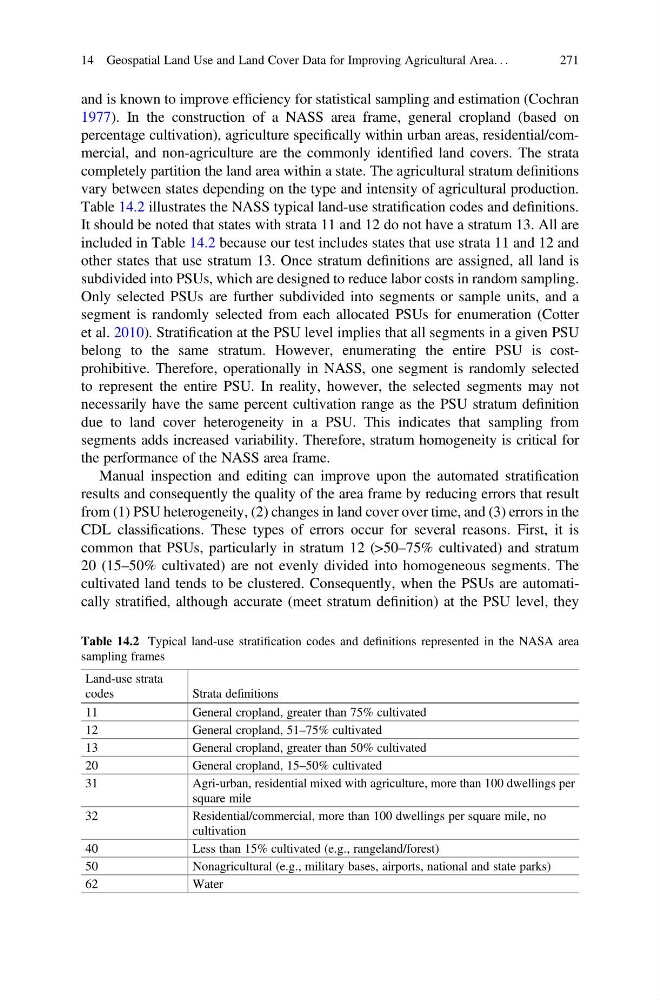
Table 14.2 illustrates the NASS typical land-use stratification codes and definitions.
It should be noted that states with strata 11 and 12 do not have a stratum 13. All are
included in Table 14.2 because our test includes states that use strata 11 and 12 and
other states that use stratum 13. Once stratum definitions are assigned, all land is
subdivided into PSUs, which are designed to reduce labor costs in random sampling.
Only selected PSUs are further subdivided into segments or sample units, and a
segment is randomly selected from each allocated PSUs for enumeration (Cotter
et al. 2010). Stratification at the PSU level implies that all segments in a given PSU
belong to the same stratum. However, enumerating the entire PSU is costprohibitive. Therefore, operationally in NASS, one segment is randomly selected
to represent the entire PSU. In reality, however, the selected segments may not
necessarily have the same percent cultivation range as the PSU stratum definition
due to land cover heterogeneity in a PSU. This indicates that sampling from
segments adds increased variability. Therefore, stratum homogeneity is critical for
the performance of the NASS area frame.
Manual inspection and editing can improve upon the automated stratification
results and consequently the quality of the area frame by reducing errors that result
from (1) PSU heterogeneity, (2) changes in land cover over time, and (3) errors in the
CDL classifications. These types of errors occur for several reasons. First, it is
common that PSUs, particularly in stratum 12 (>50–75% cultivated) and stratum
20 (15–50% cultivated) are not evenly divided into homogeneous segments. The
cultivated land tends to be clustered. Consequently, when the PSUs are automatically stratified, although accurate (meet stratum definition) at the PSU level, they
Table 14.2 Typical land-use stratification codes and definitions represented in the NASA area
sampling frames
Land-use strata
codes
Strata definitions
11
General cropland, greater than 75% cultivated
12
General cropland, 51–75% cultivated
13
General cropland, greater than 50% cultivated
20
General cropland, 15–50% cultivated
31
Agri-urban, residential mixed with agriculture, more than 100 dwellings per
square mile
32
Residential/commercial, more than 100 dwellings per square mile, no
cultivation
40
Less than 15% cultivated (e.g., rangeland/forest)
50
Nonagricultural (e.g., military bases, airports, national and state parks)
62
Water
14 Geospatial Land Use and Land Cover Data for Improving Agricultural Area. . .
271
1977). In the construction of a NASS area frame, general cropland (based on
percentage cultivation), agriculture specifically within urban areas, residential/commercial, and non-agriculture are the commonly identified land covers. The strata
completely partition the land area within a state. The agricultural stratum definitions
vary between states depending on the type and intensity of agricultural production.
Table 14.2 illustrates the NASS typical land-use stratification codes and definitions.
It should be noted that states with strata 11 and 12 do not have a stratum 13. All are
included in Table 14.2 because our test includes states that use strata 11 and 12 and
other states that use stratum 13. Once stratum definitions are assigned, all land is
subdivided into PSUs, which are designed to reduce labor costs in random sampling.
Only selected PSUs are further subdivided into segments or sample units, and a
segment is randomly selected from each allocated PSUs for enumeration (Cotter
et al. 2010). Stratification at the PSU level implies that all segments in a given PSU
belong to the same stratum. However, enumerating the entire PSU is costprohibitive. Therefore, operationally in NASS, one segment is randomly selected
to represent the entire PSU. In reality, however, the selected segments may not
necessarily have the same percent cultivation range as the PSU stratum definition
due to land cover heterogeneity in a PSU. This indicates that sampling from
segments adds increased variability. Therefore, stratum homogeneity is critical for
the performance of the NASS area frame.
Manual inspection and editing can improve upon the automated stratification
results and consequently the quality of the area frame by reducing errors that result
from (1) PSU heterogeneity, (2) changes in land cover over time, and (3) errors in the
CDL classifications. These types of errors occur for several reasons. First, it is
common that PSUs, particularly in stratum 12 (>50–75% cultivated) and stratum
20 (15–50% cultivated) are not evenly divided into homogeneous segments. The
cultivated land tends to be clustered. Consequently, when the PSUs are automatically stratified, although accurate (meet stratum definition) at the PSU level, they
Table 14.2 Typical land-use stratification codes and definitions represented in the NASA area
sampling frames
Land-use strata
codes
Strata definitions
11
General cropland, greater than 75% cultivated
12
General cropland, 51–75% cultivated
13
General cropland, greater than 50% cultivated
20
General cropland, 15–50% cultivated
31
Agri-urban, residential mixed with agriculture, more than 100 dwellings per
square mile
32
Residential/commercial, more than 100 dwellings per square mile, no
cultivation
40
Less than 15% cultivated (e.g., rangeland/forest)
50
Nonagricultural (e.g., military bases, airports, national and state parks)
62
Water
14 Geospatial Land Use and Land Cover Data for Improving Agricultural Area. . .
271