

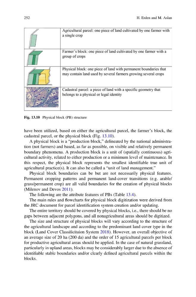
have been utilized, based on either the agricultural parcel, the farmer’s block, the
cadastral parcel, or the physical block (Fig. 13.10).
A physical block is a “production block,” delineated by the national administration (not farmers) and based, as far as possible, on visible and relatively permanent
boundary phenomena. A production block is a unit of (spatially continuous) agricultural activity, related to either production or a minimum level of maintenance. In
this respect, the physical block represents the smallest identifiable true unit of
agricultural practice(s). It can also be called a “unit of land management.”
Physical block boundaries can be but are not necessarily physical features.
Permanent cropping patterns and permanent land-cover transitions (e.g. arable/
grass/permanent crop) are all valid boundaries for the creation of physical blocks
(Milenov and Devos 2011).
The following are the attribute features of PBs (Table 13.4).
The main rules and flowcharts for physical block digitization were derived from
the JRC document for parcel identification system creation and/or updating.
The entire territory should be covered by physical blocks, i.e., there should be no
gaps between adjacent polygons, and all nonagricultural areas should be digitized.
The size and structure of physical blocks will vary according to the structure of
the agricultural landscape and according to the predominant land cover type in the
block (Land Cover Classificitaion System 2018). However, an overall objective of
an average size of 20 ha (200 da) and the order of 15 agricultural parcels per block
for productive agricultural areas should be applied. In the case of natural grassland,
particularly in upland areas, blocks may be considerably larger due to the absence of
identifiable stable boundaries and/or clearly defined agricultural parcels within the
blocks.
Fig. 13.10 Physical block (PB) structure
252
H. Erden and M. Aslan
cadastral parcel, or the physical block (Fig. 13.10).
A physical block is a “production block,” delineated by the national administration (not farmers) and based, as far as possible, on visible and relatively permanent
boundary phenomena. A production block is a unit of (spatially continuous) agricultural activity, related to either production or a minimum level of maintenance. In
this respect, the physical block represents the smallest identifiable true unit of
agricultural practice(s). It can also be called a “unit of land management.”
Physical block boundaries can be but are not necessarily physical features.
Permanent cropping patterns and permanent land-cover transitions (e.g. arable/
grass/permanent crop) are all valid boundaries for the creation of physical blocks
(Milenov and Devos 2011).
The following are the attribute features of PBs (Table 13.4).
The main rules and flowcharts for physical block digitization were derived from
the JRC document for parcel identification system creation and/or updating.
The entire territory should be covered by physical blocks, i.e., there should be no
gaps between adjacent polygons, and all nonagricultural areas should be digitized.
The size and structure of physical blocks will vary according to the structure of
the agricultural landscape and according to the predominant land cover type in the
block (Land Cover Classificitaion System 2018). However, an overall objective of
an average size of 20 ha (200 da) and the order of 15 agricultural parcels per block
for productive agricultural areas should be applied. In the case of natural grassland,
particularly in upland areas, blocks may be considerably larger due to the absence of
identifiable stable boundaries and/or clearly defined agricultural parcels within the
blocks.
Fig. 13.10 Physical block (PB) structure
252
H. Erden and M. Aslan