

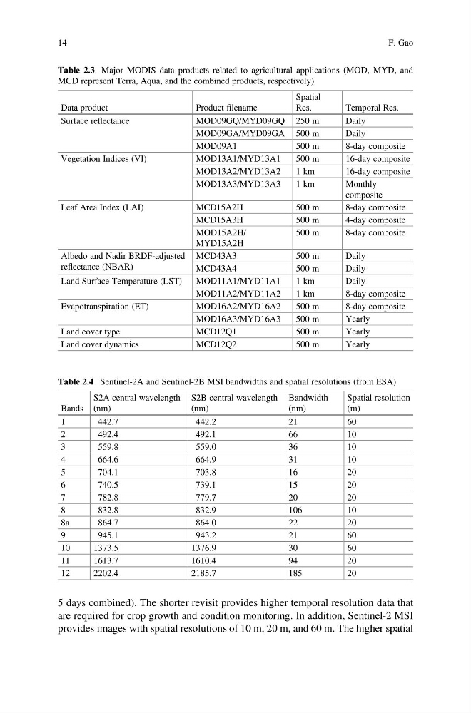
5 days combined). The shorter revisit provides higher temporal resolution data that
are required for crop growth and condition monitoring. In addition, Sentinel-2 MSI
provides images with spatial resolutions of 10 m, 20 m, and 60 m. The higher spatial
Table 2.3 Major MODIS data products related to agricultural applications (MOD, MYD, and
MCD represent Terra, Aqua, and the combined products, respectively)
Data product
Product filename
Spatial
Res.
Temporal Res.
Surface reflectance
MOD09GQ/MYD09GQ 250 m
Daily
MOD09GA/MYD09GA 500 m
Daily
MOD09A1
500 m
8-day composite
Vegetation Indices (VI)
MOD13A1/MYD13A1
500 m
16-day composite
MOD13A2/MYD13A2
1 km
16-day composite
MOD13A3/MYD13A3
1 km
Monthly
composite
Leaf Area Index (LAI)
MCD15A2H
500 m
8-day composite
MCD15A3H
500 m
4-day composite
MOD15A2H/
MYD15A2H
500 m
8-day composite
Albedo and Nadir BRDF-adjusted
reflectance (NBAR)
MCD43A3
500 m
Daily
MCD43A4
500 m
Daily
Land Surface Temperature (LST)
MOD11A1/MYD11A1
1 km
Daily
MOD11A2/MYD11A2
1 km
8-day composite
Evapotranspiration (ET)
MOD16A2/MYD16A2
500 m
8-day composite
MOD16A3/MYD16A3
500 m
Yearly
Land cover type
MCD12Q1
500 m
Yearly
Land cover dynamics
MCD12Q2
500 m
Yearly
Table 2.4 Sentinel-2A and Sentinel-2B MSI bandwidths and spatial resolutions (from ESA)
Bands
S2A central wavelength
(nm)
S2B central wavelength
(nm)
Bandwidth
(nm)
Spatial resolution
(m)
1
442.7
442.2
21
60
2
492.4
492.1
66
10
3
559.8
559.0
36
10
4
664.6
664.9
31
10
5
704.1
703.8
16
20
6
740.5
739.1
15
20
7
782.8
779.7
20
20
8
832.8
832.9
106
10
8a
864.7
864.0
22
20
9
945.1
943.2
21
60
10
1373.5
1376.9
30
60
11
1613.7
1610.4
94
20
12
2202.4
2185.7
185
20
14
F. Gao
are required for crop growth and condition monitoring. In addition, Sentinel-2 MSI
provides images with spatial resolutions of 10 m, 20 m, and 60 m. The higher spatial
Table 2.3 Major MODIS data products related to agricultural applications (MOD, MYD, and
MCD represent Terra, Aqua, and the combined products, respectively)
Data product
Product filename
Spatial
Res.
Temporal Res.
Surface reflectance
MOD09GQ/MYD09GQ 250 m
Daily
MOD09GA/MYD09GA 500 m
Daily
MOD09A1
500 m
8-day composite
Vegetation Indices (VI)
MOD13A1/MYD13A1
500 m
16-day composite
MOD13A2/MYD13A2
1 km
16-day composite
MOD13A3/MYD13A3
1 km
Monthly
composite
Leaf Area Index (LAI)
MCD15A2H
500 m
8-day composite
MCD15A3H
500 m
4-day composite
MOD15A2H/
MYD15A2H
500 m
8-day composite
Albedo and Nadir BRDF-adjusted
reflectance (NBAR)
MCD43A3
500 m
Daily
MCD43A4
500 m
Daily
Land Surface Temperature (LST)
MOD11A1/MYD11A1
1 km
Daily
MOD11A2/MYD11A2
1 km
8-day composite
Evapotranspiration (ET)
MOD16A2/MYD16A2
500 m
8-day composite
MOD16A3/MYD16A3
500 m
Yearly
Land cover type
MCD12Q1
500 m
Yearly
Land cover dynamics
MCD12Q2
500 m
Yearly
Table 2.4 Sentinel-2A and Sentinel-2B MSI bandwidths and spatial resolutions (from ESA)
Bands
S2A central wavelength
(nm)
S2B central wavelength
(nm)
Bandwidth
(nm)
Spatial resolution
(m)
1
442.7
442.2
21
60
2
492.4
492.1
66
10
3
559.8
559.0
36
10
4
664.6
664.9
31
10
5
704.1
703.8
16
20
6
740.5
739.1
15
20
7
782.8
779.7
20
20
8
832.8
832.9
106
10
8a
864.7
864.0
22
20
9
945.1
943.2
21
60
10
1373.5
1376.9
30
60
11
1613.7
1610.4
94
20
12
2202.4
2185.7
185
20
14
F. Gao