

Airborne remote sensing has a wider choice of high-quality sensors and is not limited
by the lightweight sensors as UAV does. However, the operation is more complex
and the cost is higher than a UAV.
Satellite remote sensing provides routine and repeatable observations on a
regional or global scale. They carry high-quality sensors and are normally wellcalibrated. Satellite images are the main data sources used in agricultural applications. As mentioned in the previous section, these sensors have different spatial,
temporal, and spectral resolutions. They can be used for different applications. This
section introduces the major global satellite data sources that are freely available to
the public.
Landsat series data have a long history starting from the early 1970s. Landsat data
are the most popular data used in agriculture, especially after the Landsat free
distribution policy was implemented in early 2008 (Woodcock et al. 2008). The
Landsat series satellites carried several instruments, including MSS (Multispectral
Scanner), TM (Thematic Mapper), ETM+ (Enhanced Thematic Mapper Plus), and
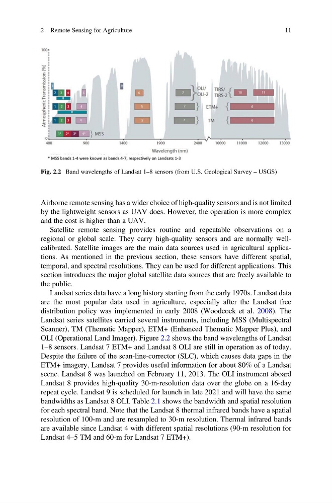
OLI (Operational Land Imager). Figure 2.2 shows the band wavelengths of Landsat
1–8 sensors. Landsat 7 ETM+ and Landsat 8 OLI are still in operation as of today.
Despite the failure of the scan-line-corrector (SLC), which causes data gaps in the
ETM+ imagery, Landsat 7 provides useful information for about 80% of a Landsat
scene. Landsat 8 was launched on February 11, 2013. The OLI instrument aboard
Landsat 8 provides high-quality 30-m-resolution data over the globe on a 16-day
repeat cycle. Landsat 9 is scheduled for launch in late 2021 and will have the same
bandwidths as Landsat 8 OLI. Table 2.1 shows the bandwidth and spatial resolution
for each spectral band. Note that the Landsat 8 thermal infrared bands have a spatial
resolution of 100-m and are resampled to 30-m resolution. Thermal infrared bands
are available since Landsat 4 with different spatial resolutions (90-m resolution for
Landsat 4–5 TM and 60-m for Landsat 7 ETM+).
Fig. 2.2 Band wavelengths of Landsat 1–8 sensors (from U.S. Geological Survey – USGS)
2 Remote Sensing for Agriculture
11
by the lightweight sensors as UAV does. However, the operation is more complex
and the cost is higher than a UAV.
Satellite remote sensing provides routine and repeatable observations on a
regional or global scale. They carry high-quality sensors and are normally wellcalibrated. Satellite images are the main data sources used in agricultural applications. As mentioned in the previous section, these sensors have different spatial,
temporal, and spectral resolutions. They can be used for different applications. This
section introduces the major global satellite data sources that are freely available to
the public.
Landsat series data have a long history starting from the early 1970s. Landsat data
are the most popular data used in agriculture, especially after the Landsat free
distribution policy was implemented in early 2008 (Woodcock et al. 2008). The
Landsat series satellites carried several instruments, including MSS (Multispectral
Scanner), TM (Thematic Mapper), ETM+ (Enhanced Thematic Mapper Plus), and
OLI (Operational Land Imager). Figure 2.2 shows the band wavelengths of Landsat
1–8 sensors. Landsat 7 ETM+ and Landsat 8 OLI are still in operation as of today.
Despite the failure of the scan-line-corrector (SLC), which causes data gaps in the
ETM+ imagery, Landsat 7 provides useful information for about 80% of a Landsat
scene. Landsat 8 was launched on February 11, 2013. The OLI instrument aboard
Landsat 8 provides high-quality 30-m-resolution data over the globe on a 16-day
repeat cycle. Landsat 9 is scheduled for launch in late 2021 and will have the same
bandwidths as Landsat 8 OLI. Table 2.1 shows the bandwidth and spatial resolution
for each spectral band. Note that the Landsat 8 thermal infrared bands have a spatial
resolution of 100-m and are resampled to 30-m resolution. Thermal infrared bands
are available since Landsat 4 with different spatial resolutions (90-m resolution for
Landsat 4–5 TM and 60-m for Landsat 7 ETM+).
Fig. 2.2 Band wavelengths of Landsat 1–8 sensors (from U.S. Geological Survey – USGS)
2 Remote Sensing for Agriculture
11