

The Application of GIS and Remote Sensing in a Spatiotemporal Analysis...
63
in 2020, Thinh et al. [35] applied the Digital Shoreline Analysis system in an anal‑
ysis of mangrove shoreline changes along the Giao Thuy coastal area (Vietnam)
from 2005 to 2014 revealing an average degradation rate of 1.41 m/year and the
growth rate of 1.26 m/year.
DSAS calculations are done through transects built along the shorelines. A base‑
line is then constructed to serve as the starting point of all transects. The intersec‑
tions between each transect and shorelines represent the point of measurement used
to calculate the shoreline evolution rate. In our study, transect spacing was 5 m
while the length was related to the distance between shorelines. Since we are more
interested in rating the evolution of the coastlines at 10-year intervals, the End Point
Rate (EPR) was used as method of calculation. The End Point Rate is the calculation
provided by dividing the distance of the oldest and most recent shoreline by the
time elapsed between them. The End Point Rate is only used to calculate the rate
of erosion/accretion between two shorelines (the oldest and youngest) expressed in
m/year and given by the equation below:
[m]
Distance between shorelines
EPR
Time
=
(1)
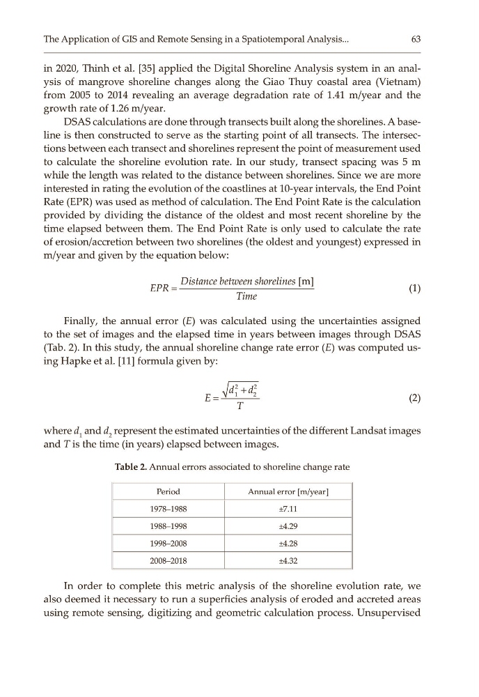
Finally, the annual error (E) was calculated using the uncertainties assigned
to the set of images and the elapsed time in years between images through DSAS
(Tab. 2). In this study, the annual shoreline change rate error (E) was computed us‑
ing Hapke et al. [11] formula given by:
2
2
1
2
d d
E
T
+
=
(2)
where d 1 and d 2 represent the estimated uncertainties of the different Landsat images
and T is the time (in years) elapsed between images.
Table 2. Annual errors associated to shoreline change rate
Period
Annual error [m/year]
1978–1988
±7.11
1988–1998
±4.29
1998–2008
±4.28
2008–2018
±4.32
In order to complete this metric analysis of the shoreline evolution rate, we
also deemed it necessary to run a superficies analysis of eroded and accreted areas
using remote sensing, digitizing and geometric calculation process. Unsupervised
63
in 2020, Thinh et al. [35] applied the Digital Shoreline Analysis system in an anal‑
ysis of mangrove shoreline changes along the Giao Thuy coastal area (Vietnam)
from 2005 to 2014 revealing an average degradation rate of 1.41 m/year and the
growth rate of 1.26 m/year.
DSAS calculations are done through transects built along the shorelines. A base‑
line is then constructed to serve as the starting point of all transects. The intersec‑
tions between each transect and shorelines represent the point of measurement used
to calculate the shoreline evolution rate. In our study, transect spacing was 5 m
while the length was related to the distance between shorelines. Since we are more
interested in rating the evolution of the coastlines at 10-year intervals, the End Point
Rate (EPR) was used as method of calculation. The End Point Rate is the calculation
provided by dividing the distance of the oldest and most recent shoreline by the
time elapsed between them. The End Point Rate is only used to calculate the rate
of erosion/accretion between two shorelines (the oldest and youngest) expressed in
m/year and given by the equation below:
[m]
Distance between shorelines
EPR
Time
=
(1)
Finally, the annual error (E) was calculated using the uncertainties assigned
to the set of images and the elapsed time in years between images through DSAS
(Tab. 2). In this study, the annual shoreline change rate error (E) was computed us‑
ing Hapke et al. [11] formula given by:
2
2
1
2
d d
E
T
+
=
(2)
where d 1 and d 2 represent the estimated uncertainties of the different Landsat images
and T is the time (in years) elapsed between images.
Table 2. Annual errors associated to shoreline change rate
Period
Annual error [m/year]
1978–1988
±7.11
1988–1998
±4.29
1998–2008
±4.28
2008–2018
±4.32
In order to complete this metric analysis of the shoreline evolution rate, we
also deemed it necessary to run a superficies analysis of eroded and accreted areas
using remote sensing, digitizing and geometric calculation process. Unsupervised