

100
Coastal Engineering: Theory and Practice
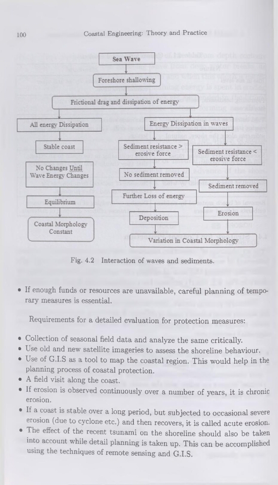
Fig. 4.2 Interaction of waves and sédiments.
• If enough funds or resources are unavailable, careful planning of temporary measures is essential.
Requirements for a detailed évaluation for protection measures:
• Collection of seasonal field data and analyze the same critically.
• Lse old and new satellite imageries to assess the shoreline behaviour.
• Use of G.I.S as a tool to map the Coastal région. This would help in the
planning process of Coastal protection.
• A field visit along the coast.
• If érosion is observed continuously over a number of years, it is chronic
érosion.
• If a coast is stable over a long period, but subjected to occasional severe
érosion (due to cyclone etc.) and then recovers, it is called acute érosion.
• The effect of the recent tsunami on the shoreline should also be taken
into account while detail planning is taken up. This can be accomplished
using the techniques of remote sensing and G.I.S.
Coastal Engineering: Theory and Practice
Fig. 4.2 Interaction of waves and sédiments.
• If enough funds or resources are unavailable, careful planning of temporary measures is essential.
Requirements for a detailed évaluation for protection measures:
• Collection of seasonal field data and analyze the same critically.
• Lse old and new satellite imageries to assess the shoreline behaviour.
• Use of G.I.S as a tool to map the Coastal région. This would help in the
planning process of Coastal protection.
• A field visit along the coast.
• If érosion is observed continuously over a number of years, it is chronic
érosion.
• If a coast is stable over a long period, but subjected to occasional severe
érosion (due to cyclone etc.) and then recovers, it is called acute érosion.
• The effect of the recent tsunami on the shoreline should also be taken
into account while detail planning is taken up. This can be accomplished
using the techniques of remote sensing and G.I.S.