

V. Gouretski
98
-190
-180
-170
-160
-150
-140
-130
-120
-110
-100
Longitude
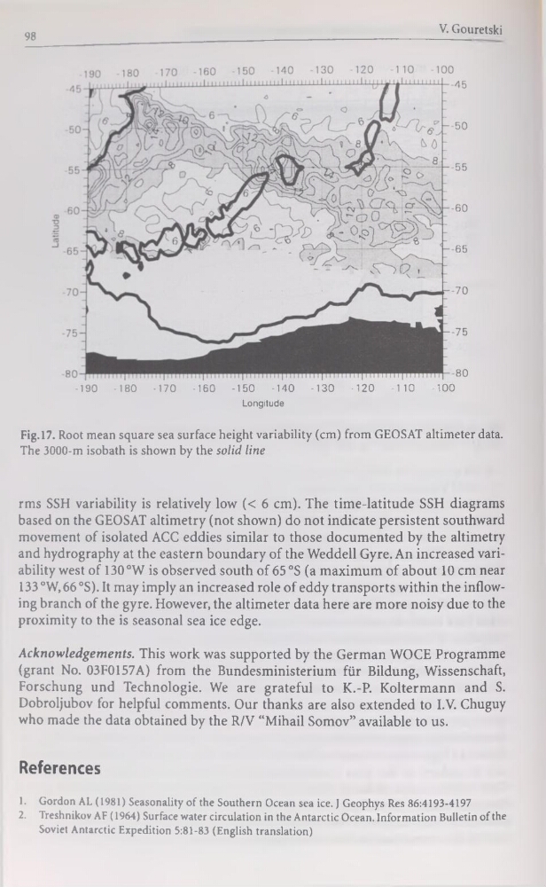
Fig. 17. Root mean square sea surface height variability (cm) from GEOSAT altimeter data.
The 3000-m isobath is shown by the solid line
rms SSH variability is relatively low (< 6 cm). The time-latitude SSH diagrams
based on the GEOSAT altimetry (not shown) do not indicate persistent southward
movement of isolated ACC eddies similar to those documented by the altimetry
and hydrography at the eastern boundary of the Weddell Gyre. An increased variability west of 130°W is observed south of 65 °S (a maximum of about 10 cm near
133 °W, 66 °S). It may imply an increased rôle of eddy transports within the inflowing branch of the gyre. However, the altimeter data here are more noisy due to the
proximity to the is seasonal sea ice edge.
Acknowledgements. This work was supported by the German WOCE Programme
(grant No. 03F0157A) from the Bundesministerium für Bildung, Wissenschaft,
Forschung und Technologie. We are grateful to K.-P. Koltermann and S.
Dobroljubov for helpful comments. Our thanks are also extended to I.V. Chuguy
who made the data obtained by the R/V “Mihail Somov” available to us.
References
1. Gordon AL (1981) Seasonality of the Southern Océan sea ice. J Geophys Res 86:4193-4197
2. Treshnikov AF (1964) Surface water circulation in the Antarctic Océan. Information Bulletin of the
Soviet Antarctic Expédition 5:81-83 (English translation)
98
-190
-180
-170
-160
-150
-140
-130
-120
-110
-100
Longitude
Fig. 17. Root mean square sea surface height variability (cm) from GEOSAT altimeter data.
The 3000-m isobath is shown by the solid line
rms SSH variability is relatively low (< 6 cm). The time-latitude SSH diagrams
based on the GEOSAT altimetry (not shown) do not indicate persistent southward
movement of isolated ACC eddies similar to those documented by the altimetry
and hydrography at the eastern boundary of the Weddell Gyre. An increased variability west of 130°W is observed south of 65 °S (a maximum of about 10 cm near
133 °W, 66 °S). It may imply an increased rôle of eddy transports within the inflowing branch of the gyre. However, the altimeter data here are more noisy due to the
proximity to the is seasonal sea ice edge.
Acknowledgements. This work was supported by the German WOCE Programme
(grant No. 03F0157A) from the Bundesministerium für Bildung, Wissenschaft,
Forschung und Technologie. We are grateful to K.-P. Koltermann and S.
Dobroljubov for helpful comments. Our thanks are also extended to I.V. Chuguy
who made the data obtained by the R/V “Mihail Somov” available to us.
References
1. Gordon AL (1981) Seasonality of the Southern Océan sea ice. J Geophys Res 86:4193-4197
2. Treshnikov AF (1964) Surface water circulation in the Antarctic Océan. Information Bulletin of the
Soviet Antarctic Expédition 5:81-83 (English translation)