

Flow in porous media 193
The solution domain was discretized into spatial steps Δx = 200 m
and the time step was taken as Δt = 0.1 days. The initial conditions
were set so that at the beginning the saline water was confined only
to the coastal boundary at a depth equal to the entire water column.
Then the density difference generated a gravity current creating the
advancement of the salt wedge below the fresh water lens. The simulation was conducted for a period of 800,000 time steps, until quasisteady-state conditions were established. The saline wedge propagated
to a distance of about 5400 metres from the coast. The advancement of
the saline wedge toe in the inland direction is illustrated in Figure 7.11.
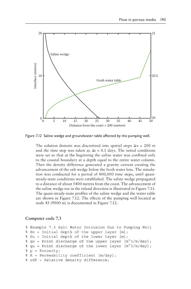
The quasi-steady-state profiles of the saline wedge and the water table
are shown in Figure 7.12. The effects of the pumping well located at
node 45 (9000 m) is documented in Figure 7.12.
Computer code 7.3
% Example 7.3 Salt Water Intrusion Due to Pumping Well
% Ho = Initial depth of the upper layer [m];
% Hu = Initial depth of the lower layer [m];
% qo = Point discharge of the upper layer [m^3/m/day];
% qu = Point discharge of the lower layer [m^3/m/day];
% p = Porosity;
% K = Permeability coefficient [m/day];
% rdf = Relative density difference;
20
10
0 0
5
10
15
20
25
30
35
40
45
50
20
20.5
21
Distance from the coast × 200 (metres)
Interface (metres)
Saline wedge
Fresh water table
Figure 7.12 Saline wedge and groundwater table affected by the pumping well.
The solution domain was discretized into spatial steps Δx = 200 m
and the time step was taken as Δt = 0.1 days. The initial conditions
were set so that at the beginning the saline water was confined only
to the coastal boundary at a depth equal to the entire water column.
Then the density difference generated a gravity current creating the
advancement of the salt wedge below the fresh water lens. The simulation was conducted for a period of 800,000 time steps, until quasisteady-state conditions were established. The saline wedge propagated
to a distance of about 5400 metres from the coast. The advancement of
the saline wedge toe in the inland direction is illustrated in Figure 7.11.
The quasi-steady-state profiles of the saline wedge and the water table
are shown in Figure 7.12. The effects of the pumping well located at
node 45 (9000 m) is documented in Figure 7.12.
Computer code 7.3
% Example 7.3 Salt Water Intrusion Due to Pumping Well
% Ho = Initial depth of the upper layer [m];
% Hu = Initial depth of the lower layer [m];
% qo = Point discharge of the upper layer [m^3/m/day];
% qu = Point discharge of the lower layer [m^3/m/day];
% p = Porosity;
% K = Permeability coefficient [m/day];
% rdf = Relative density difference;
20
10
0 0
5
10
15
20
25
30
35
40
45
50
20
20.5
21
Distance from the coast × 200 (metres)
Interface (metres)
Saline wedge
Fresh water table
Figure 7.12 Saline wedge and groundwater table affected by the pumping well.