

192 Computational Modelling in Hydraulic and Coastal Engineering
where q wo and q wu denote the discharge from a pumping well from the fresh
water (o) and the saline water (u) layers.
Example 7.3
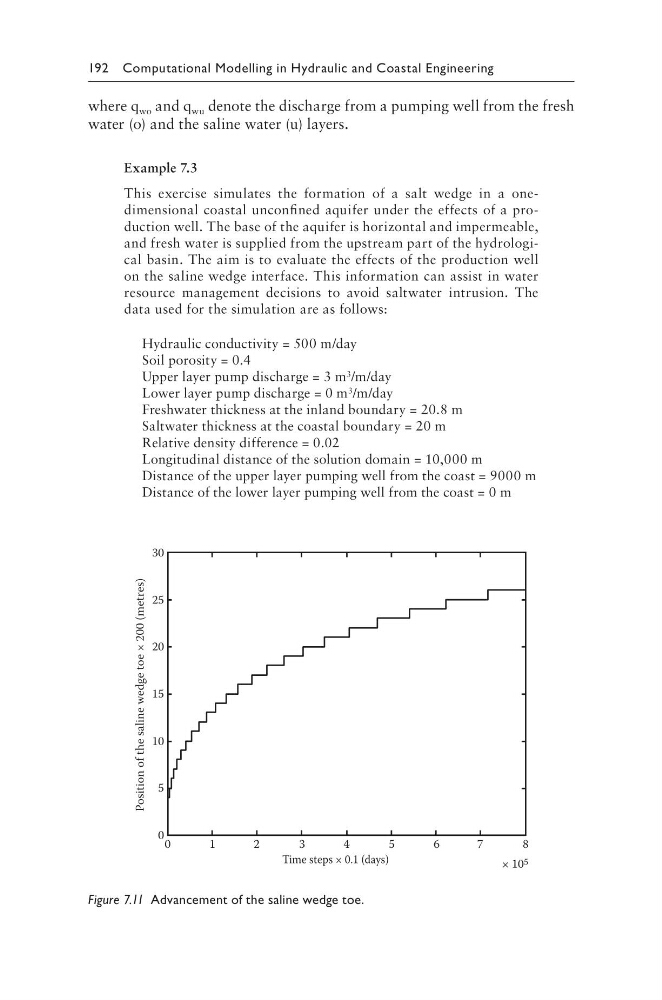
This exercise simulates the formation of a salt wedge in a onedimensional coastal unconfined aquifer under the effects of a production well. The base of the aquifer is horizontal and impermeable,
and fresh water is supplied from the upstream part of the hydrological basin. The aim is to evaluate the effects of the production well
on the saline wedge interface. This information can assist in water
resource management decisions to avoid saltwater intrusion. The
data used for the simulation are as follows:
Hydraulic conductivity = 500 m/day
Soil porosity = 0.4
Upper layer pump discharge = 3 m 3 /m/day
Lower layer pump discharge = 0 m 3 /m/day
Freshwater thickness at the inland boundary = 20.8 m
Saltwater thickness at the coastal boundary = 20 m
Relative density difference = 0.02
Longitudinal distance of the solution domain = 10,000 m
Distance of the upper layer pumping well from the coast = 9000 m
Distance of the lower layer pumping well from the coast = 0 m
30
25
20
15
10
5
0 0
1
2
3
4
5
6
7
8
Time steps × 0.1 (days)
× 10 5
Position of the saline wedge toe × 200 (metres)
Figure 7.11 Advancement of the saline wedge toe.
where q wo and q wu denote the discharge from a pumping well from the fresh
water (o) and the saline water (u) layers.
Example 7.3
This exercise simulates the formation of a salt wedge in a onedimensional coastal unconfined aquifer under the effects of a production well. The base of the aquifer is horizontal and impermeable,
and fresh water is supplied from the upstream part of the hydrological basin. The aim is to evaluate the effects of the production well
on the saline wedge interface. This information can assist in water
resource management decisions to avoid saltwater intrusion. The
data used for the simulation are as follows:
Hydraulic conductivity = 500 m/day
Soil porosity = 0.4
Upper layer pump discharge = 3 m 3 /m/day
Lower layer pump discharge = 0 m 3 /m/day
Freshwater thickness at the inland boundary = 20.8 m
Saltwater thickness at the coastal boundary = 20 m
Relative density difference = 0.02
Longitudinal distance of the solution domain = 10,000 m
Distance of the upper layer pumping well from the coast = 9000 m
Distance of the lower layer pumping well from the coast = 0 m
30
25
20
15
10
5
0 0
1
2
3
4
5
6
7
8
Time steps × 0.1 (days)
× 10 5
Position of the saline wedge toe × 200 (metres)
Figure 7.11 Advancement of the saline wedge toe.