

118 Computational Modelling in Hydraulic and Coastal Engineering
a zero-normal-flux condition is applied to the coastal boundaries. The
input data used for the simulation are as follows:
Wind velocity in the x-direction = 7 m/s
Wind velocity in the y-direction = –7 m/s
Smagorinsky parameter = 0.3
Coriolis coefficient = 0.0001 s –1
Bed friction coefficient = 10 –4
Water surface friction coefficient = 3 × 10 –6
Low limit for the horizontal eddy coefficient = 1.0 m 2 /s
The spatial discretization steps were Δx = Δy = 2000 m and the time
step Δt = 30 s
The simulation was initiated with cold-start conditions and was conducted for 21,600 time steps (7.5 days). A three-dimensional rendering
of the gulf topography is provided in Figure 5.16.
22
20
18
16
14
12
10
8
6
4
2
2
4
6
8
1 0
12
14
16
18
20
22
City of essaloniki
N
Axios and
Aliakmon rivers
outflows
2 0
2 0
2 0
45
2
0
4
5
70
7 0
45
2 0
20
45
70
95
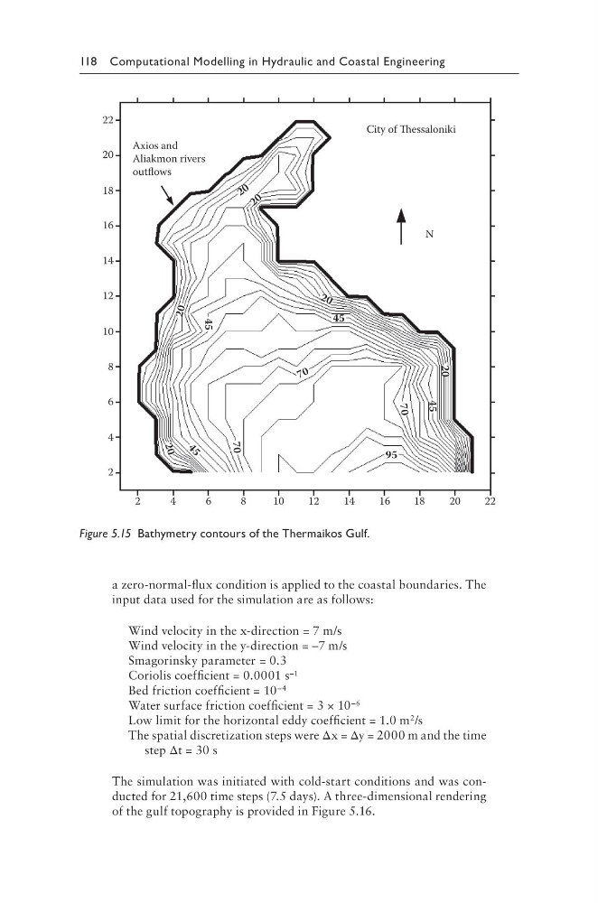
Figure 5.15 Bathymetry contours of the Thermaikos Gulf.
a zero-normal-flux condition is applied to the coastal boundaries. The
input data used for the simulation are as follows:
Wind velocity in the x-direction = 7 m/s
Wind velocity in the y-direction = –7 m/s
Smagorinsky parameter = 0.3
Coriolis coefficient = 0.0001 s –1
Bed friction coefficient = 10 –4
Water surface friction coefficient = 3 × 10 –6
Low limit for the horizontal eddy coefficient = 1.0 m 2 /s
The spatial discretization steps were Δx = Δy = 2000 m and the time
step Δt = 30 s
The simulation was initiated with cold-start conditions and was conducted for 21,600 time steps (7.5 days). A three-dimensional rendering
of the gulf topography is provided in Figure 5.16.
22
20
18
16
14
12
10
8
6
4
2
2
4
6
8
1 0
12
14
16
18
20
22
City of essaloniki
N
Axios and
Aliakmon rivers
outflows
2 0
2 0
2 0
45
2
0
4
5
70
7 0
45
2 0
20
45
70
95
Figure 5.15 Bathymetry contours of the Thermaikos Gulf.