

34
Chemical Oceanography, 4th Edition
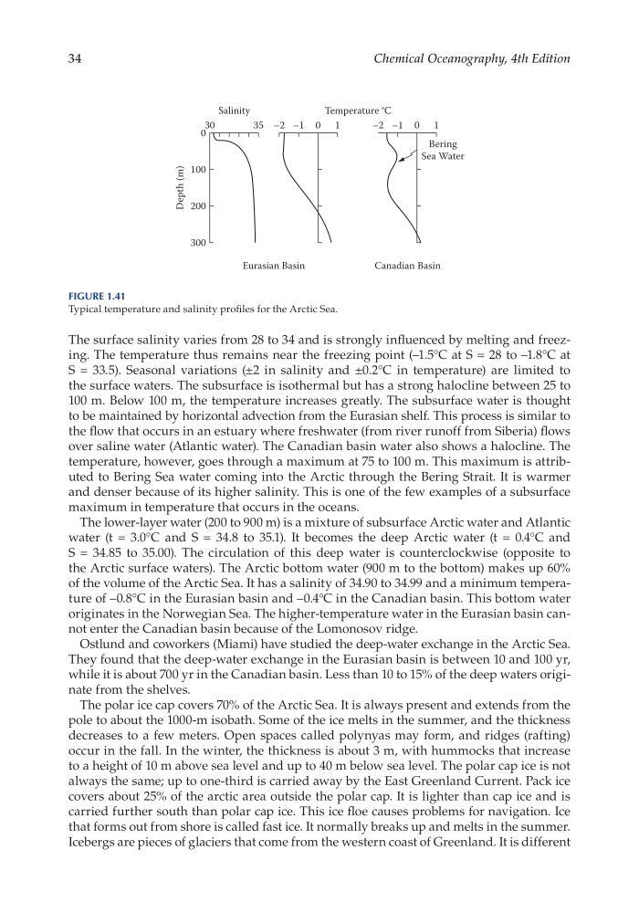
The surface salinity varies from 28 to 34 and is strongly influenced by melting and freezing. The temperature thus remains near the freezing point (–1.5°C at S = 28 to –1.8°C at
S = 33.5). Seasonal variations (±2 in salinity and ±0.2°C in temperature) are limited to
the surface waters. The subsurface is isothermal but has a strong halocline between 25 to
100 m. Below 100 m, the temperature increases greatly. The subsurface water is thought
to be maintained by horizontal advection from the Eurasian shelf. This process is similar to
the flow that occurs in an estuary where freshwater (from river runoff from Siberia) flows
over saline water (Atlantic water). The Canadian basin water also shows a halocline. The
temperature, however, goes through a maximum at 75 to 100 m. This maximum is attributed to Bering Sea water coming into the Arctic through the Bering Strait. It is warmer
and denser because of its higher salinity. This is one of the few examples of a subsurface
maximum in temperature that occurs in the oceans.
The lower- layer water (200 to 900 m) is a mixture of subsurface Arctic water and Atlantic
water (t = 3.0°C and S = 34.8 to 35.1). It becomes the deep Arctic water (t = 0.4°C and
S = 34.85 to 35.00). The circulation of this deep water is counterclockwise (opposite to
the Arctic surface waters). The Arctic bottom water (900 m to the bottom) makes up 60%
of the volume of the Arctic Sea. It has a salinity of 34.90 to 34.99 and a minimum temperature of –0.8°C in the Eurasian basin and –0.4°C in the Canadian basin. This bottom water
originates in the Norwegian Sea. The higher- temperature water in the Eurasian basin cannot enter the Canadian basin because of the Lomonosov ridge.
Ostlund and coworkers (Miami) have studied the deep- water exchange in the Arctic Sea.
They found that the deep- water exchange in the Eurasian basin is between 10 and 100 yr,
while it is about 700 yr in the Canadian basin. Less than 10 to 15% of the deep waters originate from the shelves.
The polar ice cap covers 70% of the Arctic Sea. It is always present and extends from the
pole to about the 1000-m isobath. Some of the ice melts in the summer, and the thickness
decreases to a few meters. Open spaces called polynyas may form, and ridges (rafting)
occur in the fall. In the winter, the thickness is about 3 m, with hummocks that increase
to a height of 10 m above sea level and up to 40 m below sea level. The polar cap ice is not
always the same; up to one- third is carried away by the East Greenland Current. Pack ice
covers about 25% of the arctic area outside the polar cap. It is lighter than cap ice and is
carried further south than polar cap ice. This ice floe causes problems for navigation. Ice
that forms out from shore is called fast ice. It normally breaks up and melts in the summer.
Icebergs are pieces of glaciers that come from the western coast of Greenland. It is different
100
0
30
35 –2 –1 0 1
Salinity
Temperature °C
Bering
Sea Water
Canadian Basin
Eurasian Basin
200
Depth (m)
300
–2 –1 0 1
Figure 1.41
Typical temperature and salinity profiles for the Arctic Sea.
Chemical Oceanography, 4th Edition
The surface salinity varies from 28 to 34 and is strongly influenced by melting and freezing. The temperature thus remains near the freezing point (–1.5°C at S = 28 to –1.8°C at
S = 33.5). Seasonal variations (±2 in salinity and ±0.2°C in temperature) are limited to
the surface waters. The subsurface is isothermal but has a strong halocline between 25 to
100 m. Below 100 m, the temperature increases greatly. The subsurface water is thought
to be maintained by horizontal advection from the Eurasian shelf. This process is similar to
the flow that occurs in an estuary where freshwater (from river runoff from Siberia) flows
over saline water (Atlantic water). The Canadian basin water also shows a halocline. The
temperature, however, goes through a maximum at 75 to 100 m. This maximum is attributed to Bering Sea water coming into the Arctic through the Bering Strait. It is warmer
and denser because of its higher salinity. This is one of the few examples of a subsurface
maximum in temperature that occurs in the oceans.
The lower- layer water (200 to 900 m) is a mixture of subsurface Arctic water and Atlantic
water (t = 3.0°C and S = 34.8 to 35.1). It becomes the deep Arctic water (t = 0.4°C and
S = 34.85 to 35.00). The circulation of this deep water is counterclockwise (opposite to
the Arctic surface waters). The Arctic bottom water (900 m to the bottom) makes up 60%
of the volume of the Arctic Sea. It has a salinity of 34.90 to 34.99 and a minimum temperature of –0.8°C in the Eurasian basin and –0.4°C in the Canadian basin. This bottom water
originates in the Norwegian Sea. The higher- temperature water in the Eurasian basin cannot enter the Canadian basin because of the Lomonosov ridge.
Ostlund and coworkers (Miami) have studied the deep- water exchange in the Arctic Sea.
They found that the deep- water exchange in the Eurasian basin is between 10 and 100 yr,
while it is about 700 yr in the Canadian basin. Less than 10 to 15% of the deep waters originate from the shelves.
The polar ice cap covers 70% of the Arctic Sea. It is always present and extends from the
pole to about the 1000-m isobath. Some of the ice melts in the summer, and the thickness
decreases to a few meters. Open spaces called polynyas may form, and ridges (rafting)
occur in the fall. In the winter, the thickness is about 3 m, with hummocks that increase
to a height of 10 m above sea level and up to 40 m below sea level. The polar cap ice is not
always the same; up to one- third is carried away by the East Greenland Current. Pack ice
covers about 25% of the arctic area outside the polar cap. It is lighter than cap ice and is
carried further south than polar cap ice. This ice floe causes problems for navigation. Ice
that forms out from shore is called fast ice. It normally breaks up and melts in the summer.
Icebergs are pieces of glaciers that come from the western coast of Greenland. It is different
100
0
30
35 –2 –1 0 1
Salinity
Temperature °C
Bering
Sea Water
Canadian Basin
Eurasian Basin
200
Depth (m)
300
–2 –1 0 1
Figure 1.41
Typical temperature and salinity profiles for the Arctic Sea.