

33
Descriptive Oceanography
temperatures are greater than –0.95°C (similar to the bottom water of the Arctic basin).
The Norwegian Sea thus forms a barrier to the passage of the colder Greenland gyre water.
The deep waters of both seas have high O 2 concentrations, indicating that their formation
takes place by the cooling and sinking of winter waters.
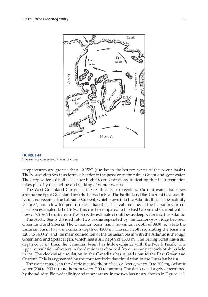
The West Greenland Current is the result of East Greenland Current water that flows
around the tip of Greenland into the Labrador Sea. The Baffin Land Bay Current flows southward and becomes the Labrador Current, which flows into the Atlantic. It has a low salinity
(30 to 34) and a low temperature (less than 0°C). The volume flow of the Labrador Current
has been estimated to be 5.6 Sv. This can be compared to the East Greenland Current with a
flow of 7.5 Sv. The difference (1.9 Sv) is the estimate of outflow as deep water into the Atlantic.
The Arctic Sea is divided into two basins separated by the Lomonosov ridge between
Greenland and Siberia. The Canadian basin has a maximum depth of 3800 m, while the
Eurasian basin has a maximum depth of 4200 m. The sill depth separating the basins is
1200 to 1400 m, and the main connection of the Eurasian basin with the Atlantic is through
Greenland and Spitzbergen, which has a sill depth of 1500 m. The Bering Strait has a sill
depth of 50 m; thus, the Canadian basin has little exchange with the North Pacific. The
upper circulation of waters in the Arctic was obtained from the early records of ships held
in ice. The clockwise circulation in the Canadian basin leads out to the East Greenland
Current. This is augmented by the counterclockwise circulation in the Eurasian basin.
The water masses in the Arctic include the surface, or Arctic, water (0 to 200 m), Atlantic
water (200 to 900 m), and bottom water (900 to bottom). The density is largely determined
by the salinity. Plots of salinity and temperature in the two basins are shown in Figure 1.41.
Canada
Norwegian C.
Can.
Basin
Eur.
Basin
E.G.C.
W.G.C.
L a b . C .
H u d s o n
B a y
G r e e n l a n d
Russia
N. Atl. C.
Figure 1.40
The surface currents of the Arctic Sea.
Descriptive Oceanography
temperatures are greater than –0.95°C (similar to the bottom water of the Arctic basin).
The Norwegian Sea thus forms a barrier to the passage of the colder Greenland gyre water.
The deep waters of both seas have high O 2 concentrations, indicating that their formation
takes place by the cooling and sinking of winter waters.
The West Greenland Current is the result of East Greenland Current water that flows
around the tip of Greenland into the Labrador Sea. The Baffin Land Bay Current flows southward and becomes the Labrador Current, which flows into the Atlantic. It has a low salinity
(30 to 34) and a low temperature (less than 0°C). The volume flow of the Labrador Current
has been estimated to be 5.6 Sv. This can be compared to the East Greenland Current with a
flow of 7.5 Sv. The difference (1.9 Sv) is the estimate of outflow as deep water into the Atlantic.
The Arctic Sea is divided into two basins separated by the Lomonosov ridge between
Greenland and Siberia. The Canadian basin has a maximum depth of 3800 m, while the
Eurasian basin has a maximum depth of 4200 m. The sill depth separating the basins is
1200 to 1400 m, and the main connection of the Eurasian basin with the Atlantic is through
Greenland and Spitzbergen, which has a sill depth of 1500 m. The Bering Strait has a sill
depth of 50 m; thus, the Canadian basin has little exchange with the North Pacific. The
upper circulation of waters in the Arctic was obtained from the early records of ships held
in ice. The clockwise circulation in the Canadian basin leads out to the East Greenland
Current. This is augmented by the counterclockwise circulation in the Eurasian basin.
The water masses in the Arctic include the surface, or Arctic, water (0 to 200 m), Atlantic
water (200 to 900 m), and bottom water (900 to bottom). The density is largely determined
by the salinity. Plots of salinity and temperature in the two basins are shown in Figure 1.41.
Canada
Norwegian C.
Can.
Basin
Eur.
Basin
E.G.C.
W.G.C.
L a b . C .
H u d s o n
B a y
G r e e n l a n d
Russia
N. Atl. C.
Figure 1.40
The surface currents of the Arctic Sea.