

28
Chemical Oceanography, 4th Edition
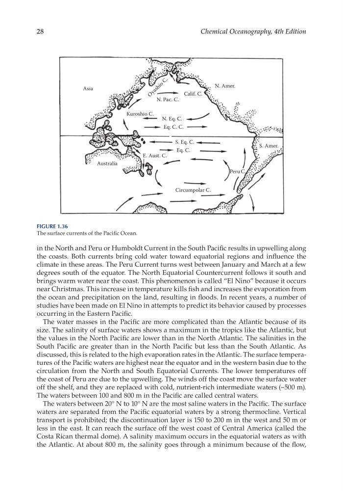
in the North and Peru or Humboldt Current in the South Pacific results in upwelling along
the coasts. Both currents bring cold water toward equatorial regions and influence the
climate in these areas. The Peru Current turns west between January and March at a few
degrees south of the equator. The North Equatorial Countercurrent follows it south and
brings warm water near the coast. This phenomenon is called “El Nino” because it occurs
near Christmas. This increase in temperature kills fish and increases the evaporation from
the ocean and precipitation on the land, resulting in floods. In recent years, a number of
studies have been made on El Nino in attempts to predict its behavior caused by processes
occurring in the Eastern Pacific.
The water masses in the Pacific are more complicated than the Atlantic because of its
size. The salinity of surface waters shows a maximum in the tropics like the Atlantic, but
the values in the North Pacific are lower than in the North Atlantic. The salinities in the
South Pacific are greater than in the North Pacific but less than the South Atlantic. As
discussed, this is related to the high evaporation rates in the Atlantic. The surface temperatures of the Pacific waters are highest near the equator and in the western basin due to the
circulation from the North and South Equatorial Currents. The lower temperatures off
the coast of Peru are due to the upwelling. The winds off the coast move the surface water
off the shelf, and they are replaced with cold, nutrient- rich intermediate waters (~500 m).
The waters between 100 and 800 m in the Pacific are called central waters.
The waters between 20° N to 10° N are the most saline waters in the Pacific. The surface
waters are separated from the Pacific equatorial waters by a strong thermocline. Vertical
transport is prohibited; the discontinuation layer is 150 to 200 m in the west and 50 m or
less in the east. It can reach the surface off the west coast of Central America (called the
Costa Rican thermal dome). A salinity maximum occurs in the equatorial waters as with
the Atlantic. At about 800 m, the salinity goes through a minimum because of the flow,
Asia
Kuroshio C.
N. Pac. C.
N. Eq. C.
S. Eq. C.
Eq. C. C.
Eq. C.
Peru C.
S. Amer.
E. Aust. C.
Australia
Circumpolar C.
Calif. C.
N. Amer.
O
y a s h i o
C .
Figure 1.36
The surface currents of the Pacific Ocean.
Chemical Oceanography, 4th Edition
in the North and Peru or Humboldt Current in the South Pacific results in upwelling along
the coasts. Both currents bring cold water toward equatorial regions and influence the
climate in these areas. The Peru Current turns west between January and March at a few
degrees south of the equator. The North Equatorial Countercurrent follows it south and
brings warm water near the coast. This phenomenon is called “El Nino” because it occurs
near Christmas. This increase in temperature kills fish and increases the evaporation from
the ocean and precipitation on the land, resulting in floods. In recent years, a number of
studies have been made on El Nino in attempts to predict its behavior caused by processes
occurring in the Eastern Pacific.
The water masses in the Pacific are more complicated than the Atlantic because of its
size. The salinity of surface waters shows a maximum in the tropics like the Atlantic, but
the values in the North Pacific are lower than in the North Atlantic. The salinities in the
South Pacific are greater than in the North Pacific but less than the South Atlantic. As
discussed, this is related to the high evaporation rates in the Atlantic. The surface temperatures of the Pacific waters are highest near the equator and in the western basin due to the
circulation from the North and South Equatorial Currents. The lower temperatures off
the coast of Peru are due to the upwelling. The winds off the coast move the surface water
off the shelf, and they are replaced with cold, nutrient- rich intermediate waters (~500 m).
The waters between 100 and 800 m in the Pacific are called central waters.
The waters between 20° N to 10° N are the most saline waters in the Pacific. The surface
waters are separated from the Pacific equatorial waters by a strong thermocline. Vertical
transport is prohibited; the discontinuation layer is 150 to 200 m in the west and 50 m or
less in the east. It can reach the surface off the west coast of Central America (called the
Costa Rican thermal dome). A salinity maximum occurs in the equatorial waters as with
the Atlantic. At about 800 m, the salinity goes through a minimum because of the flow,
Asia
Kuroshio C.
N. Pac. C.
N. Eq. C.
S. Eq. C.
Eq. C. C.
Eq. C.
Peru C.
S. Amer.
E. Aust. C.
Australia
Circumpolar C.
Calif. C.
N. Amer.
O
y a s h i o
C .
Figure 1.36
The surface currents of the Pacific Ocean.