

not only of currents but also of water characteristics and in particular of the fluctuations of the
interface that separates the inflowing Atlantic
from the outflowing Mediterranean Waters
(Bryden et al., 1994).
The Strait of Gibraltar has been the subject of
several field measuring programmes in recent years
(Bryden and Kinder, 1991). The longest continuous record, 2 years (October 1994–October 1996)
of continuous measurements of the current profile
and water properties at a mid-sill location on
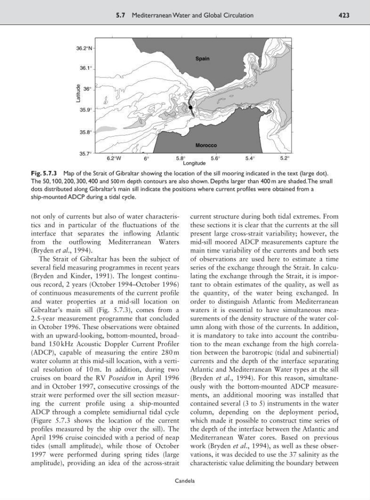
Gibraltar’s main sill (Fig. 5.7.3), comes from a
2.5-year measurement programme that concluded
in October 1996. These observations were obtained
with an upward-looking, bottom-mounted, broadband 150 kHz Acoustic Doppler Current Profiler
(ADCP), capable of measuring the entire 280 m
water column at this mid-sill location, with a vertical resolution of 10 m. In addition, during two
cruises on board the RV Poseidon in April 1996
and in October 1997, consecutive crossings of the
strait were performed over the sill section measuring the current profile using a ship-mounted
ADCP through a complete semidiurnal tidal cycle
(Figure 5.7.3 shows the location of the current
profiles measured by the ship over the sill). The
April 1996 cruise coincided with a period of neap
tides (small amplitude), while those of October
1997 were performed during spring tides (large
amplitude), providing an idea of the across-strait
current structure during both tidal extremes. From
these sections it is clear that the currents at the sill
present large cross-strait variability; however, the
mid-sill moored ADCP measurements capture the
main time variability of the currents and both sets
of observations are used here to estimate a time
series of the exchange through the Strait. In calculating the exchange through the Strait, it is important to obtain estimates of the quality, as well as
the quantity, of the water being exchanged. In
order to distinguish Atlantic from Mediterranean
waters it is essential to have simultaneous measurements of the density structure of the water column along with those of the currents. In addition,
it is mandatory to take into account the contribution to the mean exchange from the high correlation between the barotropic (tidal and subinertial)
currents and the depth of the interface separating
Atlantic and Mediterranean Water types at the sill
(Bryden et al., 1994). For this reason, simultaneously with the bottom-mounted ADCP measurements, an additional mooring was installed that
contained several (3 to 5) instruments in the water
column, depending on the deployment period,
which made it possible to construct time series of
the depth of the interface between the Atlantic and
Mediterranean Water cores. Based on previous
work (Bryden et al., 1994), as well as these observations, it was decided to use the 37 salinity as the
characteristic value delimiting the boundary between
5.7 Mediterranean Water and Global Circulation
423
Candela
6.2°W
6°
5.8°
5.6°
5.4°
35.7°
35.8°
35.9°
36°
36.1°
36.2°N
0
Spain
Morocco
Longitude
Latitude
5.2°
Fig. 5.7.3 Map of the Strait of Gibraltar showing the location of the sill mooring indicated in the text (large dot).
The 50, 100, 200, 300, 400 and 500 m depth contours are also shown. Depths larger than 400 m are shaded.The small
dots distributed along Gibraltar’s main sill indicate the positions where current profiles were obtained from a
ship-mounted ADCP during a tidal cycle.
interface that separates the inflowing Atlantic
from the outflowing Mediterranean Waters
(Bryden et al., 1994).
The Strait of Gibraltar has been the subject of
several field measuring programmes in recent years
(Bryden and Kinder, 1991). The longest continuous record, 2 years (October 1994–October 1996)
of continuous measurements of the current profile
and water properties at a mid-sill location on
Gibraltar’s main sill (Fig. 5.7.3), comes from a
2.5-year measurement programme that concluded
in October 1996. These observations were obtained
with an upward-looking, bottom-mounted, broadband 150 kHz Acoustic Doppler Current Profiler
(ADCP), capable of measuring the entire 280 m
water column at this mid-sill location, with a vertical resolution of 10 m. In addition, during two
cruises on board the RV Poseidon in April 1996
and in October 1997, consecutive crossings of the
strait were performed over the sill section measuring the current profile using a ship-mounted
ADCP through a complete semidiurnal tidal cycle
(Figure 5.7.3 shows the location of the current
profiles measured by the ship over the sill). The
April 1996 cruise coincided with a period of neap
tides (small amplitude), while those of October
1997 were performed during spring tides (large
amplitude), providing an idea of the across-strait
current structure during both tidal extremes. From
these sections it is clear that the currents at the sill
present large cross-strait variability; however, the
mid-sill moored ADCP measurements capture the
main time variability of the currents and both sets
of observations are used here to estimate a time
series of the exchange through the Strait. In calculating the exchange through the Strait, it is important to obtain estimates of the quality, as well as
the quantity, of the water being exchanged. In
order to distinguish Atlantic from Mediterranean
waters it is essential to have simultaneous measurements of the density structure of the water column along with those of the currents. In addition,
it is mandatory to take into account the contribution to the mean exchange from the high correlation between the barotropic (tidal and subinertial)
currents and the depth of the interface separating
Atlantic and Mediterranean Water types at the sill
(Bryden et al., 1994). For this reason, simultaneously with the bottom-mounted ADCP measurements, an additional mooring was installed that
contained several (3 to 5) instruments in the water
column, depending on the deployment period,
which made it possible to construct time series of
the depth of the interface between the Atlantic and
Mediterranean Water cores. Based on previous
work (Bryden et al., 1994), as well as these observations, it was decided to use the 37 salinity as the
characteristic value delimiting the boundary between
5.7 Mediterranean Water and Global Circulation
423
Candela
6.2°W
6°
5.8°
5.6°
5.4°
35.7°
35.8°
35.9°
36°
36.1°
36.2°N
0
Spain
Morocco
Longitude
Latitude
5.2°
Fig. 5.7.3 Map of the Strait of Gibraltar showing the location of the sill mooring indicated in the text (large dot).
The 50, 100, 200, 300, 400 and 500 m depth contours are also shown. Depths larger than 400 m are shaded.The small
dots distributed along Gibraltar’s main sill indicate the positions where current profiles were obtained from a
ship-mounted ADCP during a tidal cycle.