

The Mediterranean Sea, the Mare Nostrum of
the Romans, is a semi-enclosed sea with a broad
history intimately related to the development of
western civilization, but only recently have oceanographers recognized that the waters of the Mediterranean provide them with a model of the world
ocean itself (Lacombe, 1990). Geographically it
has a zonal extent of about 4000 km and a mean
meridional width of 1000 km, with a mean depth
of 1500 m and a maximum depth of up to 5000 m
in the Ionian Sea. It is divided by the Strait of Sicily
into Western and Eastern basins (Fig. 5.7.2). Mainly
an evaporative basin, it acts to transform relatively
fresh North Atlantic surface water (salinity of
SECTION 5 FORMATION AND TRANSPORT OF WATER MASSES
420
15°
20°
25°
30°
35°
40°
45°
50°
55°
60°N
15°
20°
25°
30°
35°
40°
45°
50°
55°
60°N
35
3 5
3 5
35
35
3 5 .2
3 5 .2
3 5 . 2
3 5 . 2
35 .4
3 5 .6
3 5 .6
3 5 .8
Cape St. Vincent
100°W
80°
60°
40°
20°
0°
20°E
4
4
5
5
5
5
6
6
6
6
6
6
6
7
7
7
8
8
9
9
1 0
Cape St. Vincent
(a)
(b)
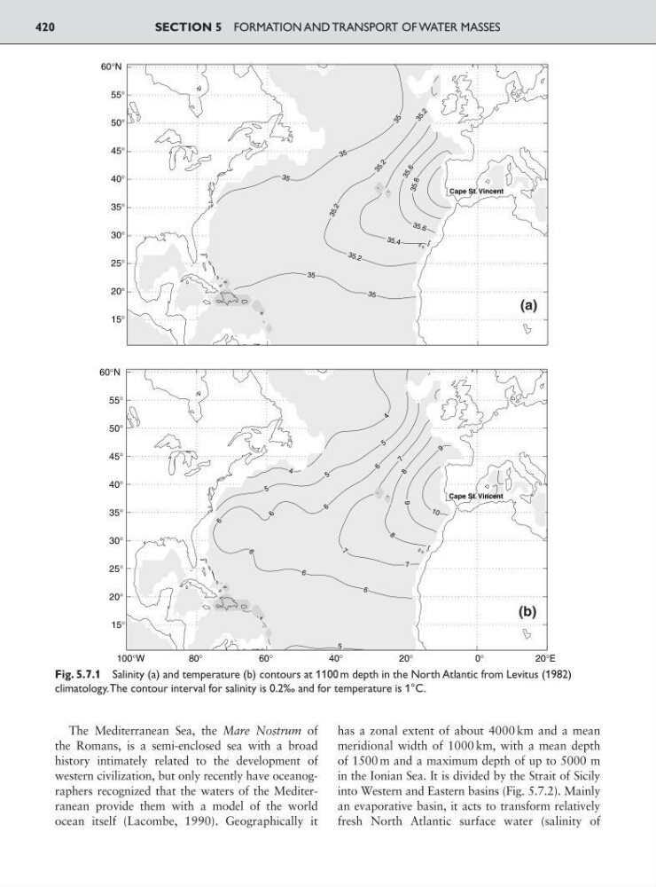
Fig. 5.7.1 Salinity (a) and temperature (b) contours at 1100 m depth in the North Atlantic from Levitus (1982)
climatology.The contour interval for salinity is 0.2‰ and for temperature is 1°C.
the Romans, is a semi-enclosed sea with a broad
history intimately related to the development of
western civilization, but only recently have oceanographers recognized that the waters of the Mediterranean provide them with a model of the world
ocean itself (Lacombe, 1990). Geographically it
has a zonal extent of about 4000 km and a mean
meridional width of 1000 km, with a mean depth
of 1500 m and a maximum depth of up to 5000 m
in the Ionian Sea. It is divided by the Strait of Sicily
into Western and Eastern basins (Fig. 5.7.2). Mainly
an evaporative basin, it acts to transform relatively
fresh North Atlantic surface water (salinity of
SECTION 5 FORMATION AND TRANSPORT OF WATER MASSES
420
15°
20°
25°
30°
35°
40°
45°
50°
55°
60°N
15°
20°
25°
30°
35°
40°
45°
50°
55°
60°N
35
3 5
3 5
35
35
3 5 .2
3 5 .2
3 5 . 2
3 5 . 2
35 .4
3 5 .6
3 5 .6
3 5 .8
Cape St. Vincent
100°W
80°
60°
40°
20°
0°
20°E
4
4
5
5
5
5
6
6
6
6
6
6
6
7
7
7
8
8
9
9
1 0
Cape St. Vincent
(a)
(b)
Fig. 5.7.1 Salinity (a) and temperature (b) contours at 1100 m depth in the North Atlantic from Levitus (1982)
climatology.The contour interval for salinity is 0.2‰ and for temperature is 1°C.