

The inflowing water is resolved into three distinct
branches: ‘flow westward (and then southward) at
Fram Strait; flow northward through the Fram
Strait and then around the Arctic Ocean; and flow
passing through the Barents Sea and then through
the Arctic Ocean. These branches, with modified
hydrographic properties, return southward as distinct layers of the East Greenland Current, the former two to supply the Denmark Strait overflow,
the latter to supply the Iceland–Scotland overflow’
(through the Faroe Bank Channel). ‘The principal
water mass product of the Iceland and Greenland
Seas is an intermediate water mass that (also) supplies the Iceland–Scotland overflow.’ In a second
paper Mauritzen (1996b) quantifies the transports
and associated air–sea exchanges. Earlier work
by Swift and Aagaard (1981) and subsequent
researchers emphasized the role of conversions
within the Nordic Seas and just north of Iceland,
but Mauritzen (1996a,b) showed that in the
former case the air–sea fluxes could not sustain
the required conversion rate.
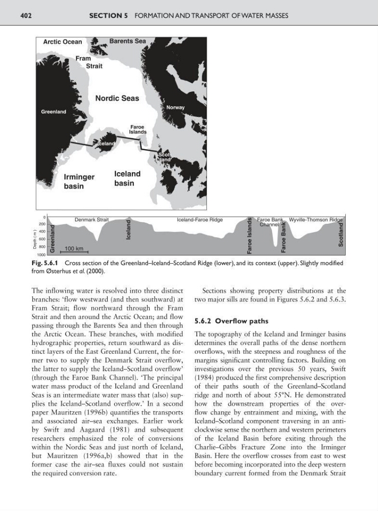
Sections showing property distributions at the
two major sills are found in Figures 5.6.2 and 5.6.3.
5.6.2 Overflow paths
The topography of the Iceland and Irminger basins
determines the overall paths of the dense northern
overflows, with the steepness and roughness of the
margins significant controlling factors. Building on
investigations over the previous 50 years, Swift
(1984) produced the first comprehensive description
of their paths south of the Greenland–Scotland
ridge and north of about 55°N. He demonstrated
how the downstream properties of the overflow change by entrainment and mixing, with the
Iceland–Scotland component traversing in an anticlockwise sense the northern and western perimeters
of the Iceland Basin before exiting through the
Charlie–Gibbs Fracture Zone into the Irminger
Basin. Here the overflow crosses from east to west
before becoming incorporated into the deep western
boundary current formed from the Denmark Strait
SECTION 5 FORMATION AND TRANSPORT OF WATER MASSES
402
Scotland
Norway
30
20
Arctic Ocean
Greenland
Norway
Iceland
Scotland
0
200
400
600
800
Denmark Strait
Iceland-Faroe Ridge
Greenland
Scotland
Faroe Islands
Iceland
Faroe Bank
Channel
Wyville-Thomson Ridge
Faroe Bank
Depth ( m )
1000
100 km
Faroe
Islands
Nordic Seas
Iceland
basin
Irminger
basin
Barents Sea
Fram
Strait
Fig. 5.6.1 Cross section of the Greenland–Iceland–Scotland Ridge (lower), and its context (upper). Slightly modified
from Østerhus et al. (2000).
branches: ‘flow westward (and then southward) at
Fram Strait; flow northward through the Fram
Strait and then around the Arctic Ocean; and flow
passing through the Barents Sea and then through
the Arctic Ocean. These branches, with modified
hydrographic properties, return southward as distinct layers of the East Greenland Current, the former two to supply the Denmark Strait overflow,
the latter to supply the Iceland–Scotland overflow’
(through the Faroe Bank Channel). ‘The principal
water mass product of the Iceland and Greenland
Seas is an intermediate water mass that (also) supplies the Iceland–Scotland overflow.’ In a second
paper Mauritzen (1996b) quantifies the transports
and associated air–sea exchanges. Earlier work
by Swift and Aagaard (1981) and subsequent
researchers emphasized the role of conversions
within the Nordic Seas and just north of Iceland,
but Mauritzen (1996a,b) showed that in the
former case the air–sea fluxes could not sustain
the required conversion rate.
Sections showing property distributions at the
two major sills are found in Figures 5.6.2 and 5.6.3.
5.6.2 Overflow paths
The topography of the Iceland and Irminger basins
determines the overall paths of the dense northern
overflows, with the steepness and roughness of the
margins significant controlling factors. Building on
investigations over the previous 50 years, Swift
(1984) produced the first comprehensive description
of their paths south of the Greenland–Scotland
ridge and north of about 55°N. He demonstrated
how the downstream properties of the overflow change by entrainment and mixing, with the
Iceland–Scotland component traversing in an anticlockwise sense the northern and western perimeters
of the Iceland Basin before exiting through the
Charlie–Gibbs Fracture Zone into the Irminger
Basin. Here the overflow crosses from east to west
before becoming incorporated into the deep western
boundary current formed from the Denmark Strait
SECTION 5 FORMATION AND TRANSPORT OF WATER MASSES
402
Scotland
Norway
30
20
Arctic Ocean
Greenland
Norway
Iceland
Scotland
0
200
400
600
800
Denmark Strait
Iceland-Faroe Ridge
Greenland
Scotland
Faroe Islands
Iceland
Faroe Bank
Channel
Wyville-Thomson Ridge
Faroe Bank
Depth ( m )
1000
100 km
Faroe
Islands
Nordic Seas
Iceland
basin
Irminger
basin
Barents Sea
Fram
Strait
Fig. 5.6.1 Cross section of the Greenland–Iceland–Scotland Ridge (lower), and its context (upper). Slightly modified
from Østerhus et al. (2000).