

also be associated with the colder (7–10°C) Subantarctic Mode Water (McCartney, 1982) that is
formed in the Antarctic Circumpolar Current
region. The path of this water towards the equator
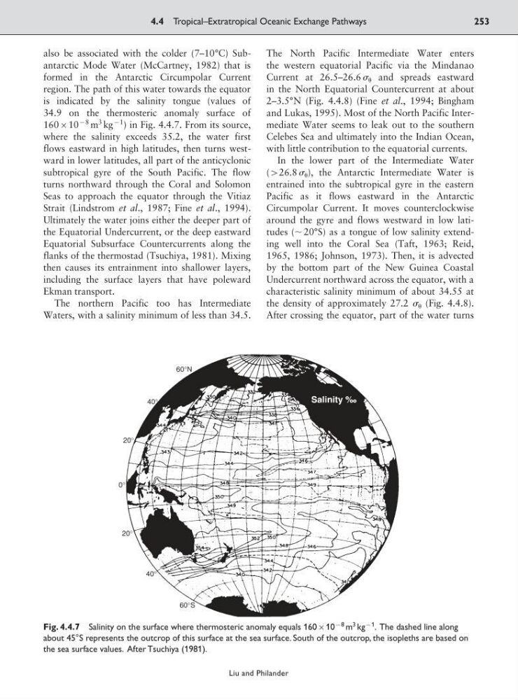
is indicated by the salinity tongue (values of
34.9 on the thermosteric anomaly surface of
16010
98 m
3 kg
91
) in Fig. 4.4.7. From its source,
where the salinity exceeds 35.2, the water first
flows eastward in high latitudes, then turns westward in lower latitudes, all part of the anticyclonic
subtropical gyre of the South Pacific. The flow
turns northward through the Coral and Solomon
Seas to approach the equator through the Vitiaz
Strait (Lindstrom et al., 1987; Fine et al., 1994).
Ultimately the water joins either the deeper part of
the Equatorial Undercurrent, or the deep eastward
Equatorial Subsurface Countercurrents along the
flanks of the thermostad (Tsuchiya, 1981). Mixing
then causes its entrainment into shallower layers,
including the surface layers that have poleward
Ekman transport.
The northern Pacific too has Intermediate
Waters, with a salinity minimum of less than 34.5.
The North Pacific Intermediate Water enters
the western equatorial Pacific via the Mindanao
Current at 26.5–26.6 and spreads eastward
in the North Equatorial Countercurrent at about
2–3.5°N (Fig. 4.4.8) (Fine et al., 1994; Bingham
and Lukas, 1995). Most of the North Pacific Intermediate Water seems to leak out to the southern
Celebes Sea and ultimately into the Indian Ocean,
with little contribution to the equatorial currents.
In the lower part of the Intermediate Water
(926.8 ), the Antarctic Intermediate Water is
entrained into the subtropical gyre in the eastern
Pacific as it flows eastward in the Antarctic
Circumpolar Current. It moves counterclockwise
around the gyre and flows westward in low latitudes (ϳ 20°S) as a tongue of low salinity extending well into the Coral Sea (Taft, 1963; Reid,
1965, 1986; Johnson, 1973). Then, it is advected
by the bottom part of the New Guinea Coastal
Undercurrent northward across the equator, with a
characteristic salinity minimum of about 34.55 at
the density of approximately 27.2 (Fig. 4.4.8).
After crossing the equator, part of the water turns
4.4 Tropical–Extratropical Oceanic Exchange Pathways
253
Liu and Philander
Fig. 4.4.7 Salinity on the surface where thermosteric anomaly equals 16010
98 m
3 kg
91 . The dashed line along
about 45°S represents the outcrop of this surface at the sea surface. South of the outcrop, the isopleths are based on
the sea surface values. After Tsuchiya (1981).
formed in the Antarctic Circumpolar Current
region. The path of this water towards the equator
is indicated by the salinity tongue (values of
34.9 on the thermosteric anomaly surface of
16010
98 m
3 kg
91
) in Fig. 4.4.7. From its source,
where the salinity exceeds 35.2, the water first
flows eastward in high latitudes, then turns westward in lower latitudes, all part of the anticyclonic
subtropical gyre of the South Pacific. The flow
turns northward through the Coral and Solomon
Seas to approach the equator through the Vitiaz
Strait (Lindstrom et al., 1987; Fine et al., 1994).
Ultimately the water joins either the deeper part of
the Equatorial Undercurrent, or the deep eastward
Equatorial Subsurface Countercurrents along the
flanks of the thermostad (Tsuchiya, 1981). Mixing
then causes its entrainment into shallower layers,
including the surface layers that have poleward
Ekman transport.
The northern Pacific too has Intermediate
Waters, with a salinity minimum of less than 34.5.
The North Pacific Intermediate Water enters
the western equatorial Pacific via the Mindanao
Current at 26.5–26.6 and spreads eastward
in the North Equatorial Countercurrent at about
2–3.5°N (Fig. 4.4.8) (Fine et al., 1994; Bingham
and Lukas, 1995). Most of the North Pacific Intermediate Water seems to leak out to the southern
Celebes Sea and ultimately into the Indian Ocean,
with little contribution to the equatorial currents.
In the lower part of the Intermediate Water
(926.8 ), the Antarctic Intermediate Water is
entrained into the subtropical gyre in the eastern
Pacific as it flows eastward in the Antarctic
Circumpolar Current. It moves counterclockwise
around the gyre and flows westward in low latitudes (ϳ 20°S) as a tongue of low salinity extending well into the Coral Sea (Taft, 1963; Reid,
1965, 1986; Johnson, 1973). Then, it is advected
by the bottom part of the New Guinea Coastal
Undercurrent northward across the equator, with a
characteristic salinity minimum of about 34.55 at
the density of approximately 27.2 (Fig. 4.4.8).
After crossing the equator, part of the water turns
4.4 Tropical–Extratropical Oceanic Exchange Pathways
253
Liu and Philander
Fig. 4.4.7 Salinity on the surface where thermosteric anomaly equals 16010
98 m
3 kg
91 . The dashed line along
about 45°S represents the outcrop of this surface at the sea surface. South of the outcrop, the isopleths are based on
the sea surface values. After Tsuchiya (1981).