

was indicated by an increase of surface float submergence with time. Some were also picked up by
fishermen or went ashore, especially around the
islands of the western tropical Pacific and the
northwest coast of North America.
If the drifters lose their drogue, the surface float
usually will continue to operate. On 32% of the
drifter data on file the submergence switch indicated severed tethers. The motion of the float, with
a 3 m segment of tether attached, was still valuable
data on water motion, provided the velocity difference between the floats with drogues attached and
those without drogues could be rationalized in
terms of other observable parameters, such as wind
and waves. A second valuable data set came from
drifters that meteorologists deployed for measuring
atmospheric pressure. Commencing in FGGE in
1978, meteorologists deployed a large number of
drifters in the Southern Oceans that typically had
cylindrical floats of 2 m length. These FGGE-type
drifters usually had no drogues or the drogues
became detached within 60 days (Garrett, 1980).
After 1983 no drogues were attached; 842 FGGEtype drifter records on file at MEDS had usable
position data. By comparing the average velocity
obtained by drifters with drogues and those without drogues or the FGGE-type drifters, it was
found that the latter slip downwind relative to
drifters with drogues by 0.88 cm s
91 per 1 m s
91 of
wind (Pazan and Niiler, 2000). Again, the NCEP
Reanalyzed winds were interpolated to the 6-hourly
drifter locations and this wind-produced bias current was removed. The data presented here also
includes the wind-slip-corrected data from WOCE/
TOGA Lagrangian drifters without drogues and
the FGGE-type drifters.
After the wind-slip corrections were applied, the
velocity data were averaged over a specified number of days and segregated into geographical bins
of specified degrees of latitude and longitude. If the
bin was too small, not many observations were
contained therein; if too large, the space scale of
the ocean circulation would be obscured. The bin
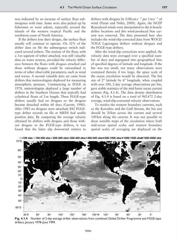
size of 2° latitude by 6° longitude, when coupled
with over 100, 2-day average observations per bin,
gave stable statistics of the mid-basin ocean current
systems (Fig. 4.1.4). The data density distribution
of Fig. 4.1.4 is based on a total of 962 672 2-day
average, wind-slip-corrected velocity observations.
To resolve the western boundary currents, such
as the Kuroshio and the Gulf Stream, the bin size
should be 20 km across the current and several
100 km along the current. It was not possible to
draw sensible maps of the circulation where both
mid-ocean spatial scales and western boundary
spatial scales of averaging are displayed on the
4.1 The World Ocean Surface Circulation
197
Niiler
30°E
60°
90°
120°
150°
180°
150°W
120°
90°
60°
30°
0°
60°S
50°
40°
30°
20°
10°
0°
10°
20°
30°
40°
50°
60°
70°N
<100 obs 100-200 obs 200-300 obs 300-400 obs 400-500 obs 500-1000 obs 1000-1500 obs 1500-4000 obs
Fig. 4.1.4 Number of 2-day average drifter observations from combined Global Drifter Programme and FGGE-type
drifters, January 1978–June 1999.
fishermen or went ashore, especially around the
islands of the western tropical Pacific and the
northwest coast of North America.
If the drifters lose their drogue, the surface float
usually will continue to operate. On 32% of the
drifter data on file the submergence switch indicated severed tethers. The motion of the float, with
a 3 m segment of tether attached, was still valuable
data on water motion, provided the velocity difference between the floats with drogues attached and
those without drogues could be rationalized in
terms of other observable parameters, such as wind
and waves. A second valuable data set came from
drifters that meteorologists deployed for measuring
atmospheric pressure. Commencing in FGGE in
1978, meteorologists deployed a large number of
drifters in the Southern Oceans that typically had
cylindrical floats of 2 m length. These FGGE-type
drifters usually had no drogues or the drogues
became detached within 60 days (Garrett, 1980).
After 1983 no drogues were attached; 842 FGGEtype drifter records on file at MEDS had usable
position data. By comparing the average velocity
obtained by drifters with drogues and those without drogues or the FGGE-type drifters, it was
found that the latter slip downwind relative to
drifters with drogues by 0.88 cm s
91 per 1 m s
91 of
wind (Pazan and Niiler, 2000). Again, the NCEP
Reanalyzed winds were interpolated to the 6-hourly
drifter locations and this wind-produced bias current was removed. The data presented here also
includes the wind-slip-corrected data from WOCE/
TOGA Lagrangian drifters without drogues and
the FGGE-type drifters.
After the wind-slip corrections were applied, the
velocity data were averaged over a specified number of days and segregated into geographical bins
of specified degrees of latitude and longitude. If the
bin was too small, not many observations were
contained therein; if too large, the space scale of
the ocean circulation would be obscured. The bin
size of 2° latitude by 6° longitude, when coupled
with over 100, 2-day average observations per bin,
gave stable statistics of the mid-basin ocean current
systems (Fig. 4.1.4). The data density distribution
of Fig. 4.1.4 is based on a total of 962 672 2-day
average, wind-slip-corrected velocity observations.
To resolve the western boundary currents, such
as the Kuroshio and the Gulf Stream, the bin size
should be 20 km across the current and several
100 km along the current. It was not possible to
draw sensible maps of the circulation where both
mid-ocean spatial scales and western boundary
spatial scales of averaging are displayed on the
4.1 The World Ocean Surface Circulation
197
Niiler
30°E
60°
90°
120°
150°
180°
150°W
120°
90°
60°
30°
0°
60°S
50°
40°
30°
20°
10°
0°
10°
20°
30°
40°
50°
60°
70°N
<100 obs 100-200 obs 200-300 obs 300-400 obs 400-500 obs 500-1000 obs 1000-1500 obs 1500-4000 obs
Fig. 4.1.4 Number of 2-day average drifter observations from combined Global Drifter Programme and FGGE-type
drifters, January 1978–June 1999.