

Garzoli et al. (1997) investigated the utility of
altimeter data in making inference on the subsurface flow fields in a region of the southeastern
Atlantic covering the path of the migration of the
Agulhas eddies and the Benguela Current. Based
on data from inverted echo sounders and current
meters deployed during the T/P mission, they
obtained a linear relationship between the sea-level
anomalies from T/P and the depth of the 10°C
isotherm (representative of the depth of the main
thermocline) as well as the surface dynamic height
(relative to 1000 m). They then used the altimeter
data to estimate the isotherm depth and dynamic
height, which in turn allowed the estimate of the
mass transport of the upper 1000 m to be made.
The altimeter-derived transports were compared
favourably with the estimates from the in-situ
data. The altimeter data were then used to study
the seasonal and interannual variability of the
transports beyond the 1-year period of in-situ data
coverage. The northward baroclinic transport of
the Benguela Current ranges from 12 to 15 Sv,
with fluctuations of up to 25 Sv. The source of the
current is mainly from the South Atlantic with
contributions from the Indian Ocean varying from
year to year.
The flow of the Pacific Ocean water into the
Indian Ocean through the Indonesian seas, the socalled Indonesian Throughflow, has a profound
impact on the global circulation and climate.
Based on simulations of an ocean general circulation model, Potemra et al. (1997) developed a
technique for relating the sea levels at four locations (south of Java, northwest of Australia, in the
Pacific warm pool, and off the Philippines) to
the transport of the throughflow. They applied the
techniques to the T/P data for estimating the
variations of the throughflow. The performance
of the approach needs to be tested by comparison
with direct observations.
In the absence of a systematic deployment of
in-situ observations in coordination with satellites,
it is not possible to construct accurate synthetic
geoid or mean ocean topography over a large
domain to study the absolute circulation of a
current system. However, one can always use climatological mean ocean topography as an approximation. For example, Lagerloef et al. (1999)
obtained reasonably accurate estimates of the
equatorial current velocity in the Pacific Ocean
using T/P data in combination with the hydrographic database of Levitus and Boyer (1994b). In
addition to the geostrophic component (including
a beta-plane version at the equator), they also used
a model for the wind-driven Ekman flow with
parameters tuned to a surface drifter data set and
a wind stress field. The estimated total velocity
field compares reasonably well with the TOGA
observations.
Without using climatology, Kelly and Gille
(1990) developed a rather ingenious technique for
estimating the absolute ocean topography across
strong currents from their temporal variabilities.
An analytical model is used to describe the ocean
topography of an isolated jet in terms of its kinematic parameters (i.e. location, width and amplitude) determined from the observed temporal
sea-level changes as an inverse problem (also see
Tai, 1990). Comparison of the altimetry-derived
velocities with simultaneous in-situ velocity
measurements demonstrated the validity of the
technique (Joyce et al., 1990). The technique was
SECTION 3 NEW WAYS OF OBSERVING THE OCEAN
166
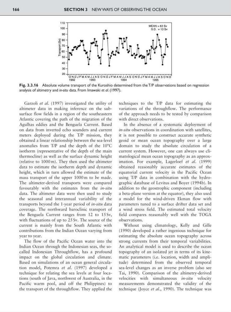
Fig. 3.3.16 Absolute volume transport of the Kuroshio determined from the T/P observations based on regression
analysis of altimetry and in-situ data. From Imawaki et al. (1997).
altimeter data in making inference on the subsurface flow fields in a region of the southeastern
Atlantic covering the path of the migration of the
Agulhas eddies and the Benguela Current. Based
on data from inverted echo sounders and current
meters deployed during the T/P mission, they
obtained a linear relationship between the sea-level
anomalies from T/P and the depth of the 10°C
isotherm (representative of the depth of the main
thermocline) as well as the surface dynamic height
(relative to 1000 m). They then used the altimeter
data to estimate the isotherm depth and dynamic
height, which in turn allowed the estimate of the
mass transport of the upper 1000 m to be made.
The altimeter-derived transports were compared
favourably with the estimates from the in-situ
data. The altimeter data were then used to study
the seasonal and interannual variability of the
transports beyond the 1-year period of in-situ data
coverage. The northward baroclinic transport of
the Benguela Current ranges from 12 to 15 Sv,
with fluctuations of up to 25 Sv. The source of the
current is mainly from the South Atlantic with
contributions from the Indian Ocean varying from
year to year.
The flow of the Pacific Ocean water into the
Indian Ocean through the Indonesian seas, the socalled Indonesian Throughflow, has a profound
impact on the global circulation and climate.
Based on simulations of an ocean general circulation model, Potemra et al. (1997) developed a
technique for relating the sea levels at four locations (south of Java, northwest of Australia, in the
Pacific warm pool, and off the Philippines) to
the transport of the throughflow. They applied the
techniques to the T/P data for estimating the
variations of the throughflow. The performance
of the approach needs to be tested by comparison
with direct observations.
In the absence of a systematic deployment of
in-situ observations in coordination with satellites,
it is not possible to construct accurate synthetic
geoid or mean ocean topography over a large
domain to study the absolute circulation of a
current system. However, one can always use climatological mean ocean topography as an approximation. For example, Lagerloef et al. (1999)
obtained reasonably accurate estimates of the
equatorial current velocity in the Pacific Ocean
using T/P data in combination with the hydrographic database of Levitus and Boyer (1994b). In
addition to the geostrophic component (including
a beta-plane version at the equator), they also used
a model for the wind-driven Ekman flow with
parameters tuned to a surface drifter data set and
a wind stress field. The estimated total velocity
field compares reasonably well with the TOGA
observations.
Without using climatology, Kelly and Gille
(1990) developed a rather ingenious technique for
estimating the absolute ocean topography across
strong currents from their temporal variabilities.
An analytical model is used to describe the ocean
topography of an isolated jet in terms of its kinematic parameters (i.e. location, width and amplitude) determined from the observed temporal
sea-level changes as an inverse problem (also see
Tai, 1990). Comparison of the altimetry-derived
velocities with simultaneous in-situ velocity
measurements demonstrated the validity of the
technique (Joyce et al., 1990). The technique was
SECTION 3 NEW WAYS OF OBSERVING THE OCEAN
166
Fig. 3.3.16 Absolute volume transport of the Kuroshio determined from the T/P observations based on regression
analysis of altimetry and in-situ data. From Imawaki et al. (1997).