

independent approach and its accuracy is a major
issue in using altimetry for studying ocean circulation (National Research Council, 1997).
The concept of satellite altimetry was demonstrated in the 1970s. A variety of missions with
different emphases were conducted in the past two
decades – Skylab (1973), GEOS-3 (1975), SEASAT
(1978), GEOSAT (1985), ERS-1 (1991), TOPEX/
POSEIDON (1992), ERS-2 (1995), GEOSAT Follow-on (1998). Among these, TOPEX/POSEIDON
(denoted by T/P hereafter) is the only altimetric
satellite specifically designed for studying the
global ocean circulation (Fu et al., 1994). The
effort includes an instrument package for measuring signal delay in the media as well as precision
satellite tracking, an optimal choice of orbit
configuration for orbit determination and tidal
sampling, and a long-lead programme in improving the knowledge of the earth’s gravity field.
A recent review of the results from the mission has
been provided by Wunsch and Stammer (1998).
The evolution of the accuracy in sea surface
height measurement has spanned more than two
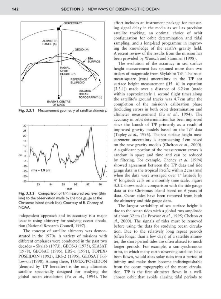
orders of magnitude from Skylab to T/P. The rootmean-square (rms) uncertainty in the T/P sea
surface height measurement ([H9h] in equation
(3.3.1)) made over a distance of 6.2 km (made
within approximately 1 second flight time) along
the satellite’s ground tracks was 4.7 cm after the
completion of the mission’s calibration phase
(including errors in both orbit determination and
altimeter measurement) (Fu et al., 1994). The
accuracy in orbit determination has been improved
since the launch of T/P primarily as a result of
improved gravity models based on the T/P data
(Tapley et al., 1996). The sea surface height measurement uncertainty is approaching 4 cm based
on the new gravity models (Chelton et al., 2000).
A significant portion of the measurement errors is
random in space and time and can be reduced
by filtering. For example, Cheney et al. (1994)
showed agreement between the T/P data and tide
gauge data in the tropical Pacific within 2 cm (rms)
when the data were averaged over 1° latitude by
4° longitude cells on a monthly time scale. Figure
3.3.2 shows such a comparison with the tide gauge
data at the Christmas Island based on 6 years of
data. Ocean tides have been removed from both
the altimetry and tide gauge data.
The largest variability of sea surface height is
due to the ocean tides with a global rms amplitude
of about 32 cm (Le Provost et al., 1995; Chelton et
al., 2000). The signals of tides must be removed
before using the data for studying ocean circulation. Due to the relatively long repeat periods
(often longer than a few days) of a satellite altimeter, the short-period tides are often aliased to much
longer periods. For example, a sun-synchronous
orbit, in which many earth-observing satellites have
been flown, would alias solar tides into a period of
infinity and make them become indistinguishable
from the ocean topography of the mean circulation. T/P is the first altimeter flown in a wellchosen orbit that avoids aliasing tidal periods to
SECTION 3 NEW WAYS OF OBSERVING THE OCEAN
142
-25
-20
-15
-10
-5
0
5
10
15
20
25
30
rms = 1.9 cm
cm
93
94
95
Year
96
97
98
Fig. 3.3.2 Comparison of T/P measured sea level (thin
line) to the observation made by the tide gauge at the
Christmas Island (thick line). Courtesy of R. Cheney of
NOAA.
GEOID (N )
RADIAL
ORBIT
HEIGHT (H )
REFERENCE
ELLIPSOID
DYNAMIC
OCEAN
TOPOGRAPHY (η)
SEA
SURFACE
ALTIMETER
RANGE (h )
SPACECRAFT
EARTH'S CENTRE
OF MASS
Fig. 3.3.1 Measurement geometry of satellite altimetry.
issue in using altimetry for studying ocean circulation (National Research Council, 1997).
The concept of satellite altimetry was demonstrated in the 1970s. A variety of missions with
different emphases were conducted in the past two
decades – Skylab (1973), GEOS-3 (1975), SEASAT
(1978), GEOSAT (1985), ERS-1 (1991), TOPEX/
POSEIDON (1992), ERS-2 (1995), GEOSAT Follow-on (1998). Among these, TOPEX/POSEIDON
(denoted by T/P hereafter) is the only altimetric
satellite specifically designed for studying the
global ocean circulation (Fu et al., 1994). The
effort includes an instrument package for measuring signal delay in the media as well as precision
satellite tracking, an optimal choice of orbit
configuration for orbit determination and tidal
sampling, and a long-lead programme in improving the knowledge of the earth’s gravity field.
A recent review of the results from the mission has
been provided by Wunsch and Stammer (1998).
The evolution of the accuracy in sea surface
height measurement has spanned more than two
orders of magnitude from Skylab to T/P. The rootmean-square (rms) uncertainty in the T/P sea
surface height measurement ([H9h] in equation
(3.3.1)) made over a distance of 6.2 km (made
within approximately 1 second flight time) along
the satellite’s ground tracks was 4.7 cm after the
completion of the mission’s calibration phase
(including errors in both orbit determination and
altimeter measurement) (Fu et al., 1994). The
accuracy in orbit determination has been improved
since the launch of T/P primarily as a result of
improved gravity models based on the T/P data
(Tapley et al., 1996). The sea surface height measurement uncertainty is approaching 4 cm based
on the new gravity models (Chelton et al., 2000).
A significant portion of the measurement errors is
random in space and time and can be reduced
by filtering. For example, Cheney et al. (1994)
showed agreement between the T/P data and tide
gauge data in the tropical Pacific within 2 cm (rms)
when the data were averaged over 1° latitude by
4° longitude cells on a monthly time scale. Figure
3.3.2 shows such a comparison with the tide gauge
data at the Christmas Island based on 6 years of
data. Ocean tides have been removed from both
the altimetry and tide gauge data.
The largest variability of sea surface height is
due to the ocean tides with a global rms amplitude
of about 32 cm (Le Provost et al., 1995; Chelton et
al., 2000). The signals of tides must be removed
before using the data for studying ocean circulation. Due to the relatively long repeat periods
(often longer than a few days) of a satellite altimeter, the short-period tides are often aliased to much
longer periods. For example, a sun-synchronous
orbit, in which many earth-observing satellites have
been flown, would alias solar tides into a period of
infinity and make them become indistinguishable
from the ocean topography of the mean circulation. T/P is the first altimeter flown in a wellchosen orbit that avoids aliasing tidal periods to
SECTION 3 NEW WAYS OF OBSERVING THE OCEAN
142
-25
-20
-15
-10
-5
0
5
10
15
20
25
30
rms = 1.9 cm
cm
93
94
95
Year
96
97
98
Fig. 3.3.2 Comparison of T/P measured sea level (thin
line) to the observation made by the tide gauge at the
Christmas Island (thick line). Courtesy of R. Cheney of
NOAA.
GEOID (N )
RADIAL
ORBIT
HEIGHT (H )
REFERENCE
ELLIPSOID
DYNAMIC
OCEAN
TOPOGRAPHY (η)
SEA
SURFACE
ALTIMETER
RANGE (h )
SPACECRAFT
EARTH'S CENTRE
OF MASS
Fig. 3.3.1 Measurement geometry of satellite altimetry.