

runoff (such as the Lena and Yenisei) have high discharges by virtue of their large drainage basin areas.
The Amazon River has both a large basin (comprising 35% of South America) and a high runoff; as
such its freshwater discharge equals the combined
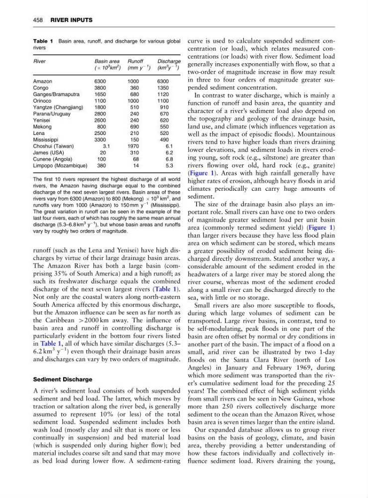
discharge of the next seven largest rivers (Table 1).
Not only are the coastal waters along north-eastern
South America affected by this enormous discharge,
but the Amazon influence can be seen as far north as
the Caribbean 42000 km away. The influence of
basin area and runoff in controlling discharge is
particularly evident in the bottom four rivers listed
in Table 1, all of which have similar discharges (5.3–
6.2 km
3 y
À1
) even though their drainage basin areas
and discharges can vary by two orders of magnitude.
Sediment Discharge
A river’s sediment load consists of both suspended
sediment and bed load. The latter, which moves by
traction or saltation along the river bed, is generally
assumed to represent 10% (or less) of the total
sediment load. Suspended sediment includes both
wash load (mostly clay and silt that is more or less
continually in suspension) and bed material load
(which is suspended only during higher flow); bed
material includes coarse silt and sand that may move
as bed load during lower flow. A sediment-rating
curve is used to calculate suspended sediment concentration (or load), which relates measured concentrations (or loads) with river flow. Sediment load
generally increases exponentially with flow, so that a
two-order of magnitude increase in flow may result
in three to four orders of magnitude greater suspended sediment concentration.
In contrast to water discharge, which is mainly a
function of runoff and basin area, the quantity and
character of a river’s sediment load also depend on
the topography and geology of the drainage basin,
land use, and climate (which influences vegetation as
well as the impact of episodic floods). Mountainous
rivers tend to have higher loads than rivers draining
lower elevations, and sediment loads in rivers eroding young, soft rock (e.g., siltstone) are greater than
rivers flowing over old, hard rock (e.g., granite)
(Figure 1). Areas with high rainfall generally have
higher rates of erosion, although heavy floods in arid
climates periodically can carry huge amounts of
sediment.
The size of the drainage basin also plays an important role. Small rivers can have one to two orders
of magnitude greater sediment load per unit basin
area (commonly termed sediment yield) (Figure 1)
than larger rivers because they have less flood plain
area on which sediment can be stored, which means
a greater possibility of eroded sediment being discharged directly downstream. Stated another way, a
considerable amount of the sediment eroded in the
headwaters of a large river may be stored along the
river course, whereas most of the sediment eroded
along a small river can be discharged directly to the
sea, with little or no storage.
Small rivers are also more susceptible to floods,
during which large volumes of sediment can be
transported. Large river basins, in contrast, tend to
be self-modulating, peak floods in one part of the
basin are often offset by normal or dry conditions in
another part of the basin. The impact of a flood on a
small, arid river can be illustrated by two 1-day
floods on the Santa Clara River (north of Los
Angeles) in January and February 1969, during
which more sediment was transported than the river’s cumulative sediment load for the preceding 25
years! The combined effect of high sediment yields
from small rivers can be seen in New Guinea, whose
more than 250 rivers collectively discharge more
sediment to the ocean than the Amazon River, whose
basin area is seven times larger than the entire island.
Our expanded database allows us to group river
basins on the basis of geology, climate, and basin
area, thereby providing a better understanding of
how these factors individually and collectively influence sediment load. Rivers draining the young,
Table 1 Basin area, runoff, and discharge for various global
rivers
River
Basin area
Runoff
Discharge
( Â 10
3 km
2 ) (mm y
À 1
) (km
3
y
À 1
)
Amazon
6300
1000
6300
Congo
3800
360
1350
Ganges/Bramaputra
1650
680
1120
Orinoco
1100
1000
1100
Yangtze (Changjiang)
1800
510
910
Parana/Uruguay
2800
240
670
Yenisei
2600
240
620
Mekong
800
690
550
Lena
2500
210
520
Mississippi
3300
150
490
Choshui (Taiwan)
3.1
1970
6.1
James (USA)
20
310
6.2
Cunene (Angola)
100
68
6.8
Limpopo (Mozambique)
380
14
5.3
The first 10 rivers represent the highest discharge of all world
rivers, the Amazon having discharge equal to the combined
discharge of the next seven largest rivers. Basin areas of these
rivers vary from 6300 (Amazon) to 800 (Mekong) Â 10
3 km
2 , and
runoffs vary from 1000 (Amazon) to 150 mm y
À1 (Mississippi).
The great variation in runoff can be seen in the example of the
last four rivers, each of which has roughly the same mean annual
discharge (5.3–6.8 km
3 y
À1
), but whose basin areas and runoffs
vary by roughly two orders of magnitude.
458 RIVER INPUTS
The Amazon River has both a large basin (comprising 35% of South America) and a high runoff; as
such its freshwater discharge equals the combined
discharge of the next seven largest rivers (Table 1).
Not only are the coastal waters along north-eastern
South America affected by this enormous discharge,
but the Amazon influence can be seen as far north as
the Caribbean 42000 km away. The influence of
basin area and runoff in controlling discharge is
particularly evident in the bottom four rivers listed
in Table 1, all of which have similar discharges (5.3–
6.2 km
3 y
À1
) even though their drainage basin areas
and discharges can vary by two orders of magnitude.
Sediment Discharge
A river’s sediment load consists of both suspended
sediment and bed load. The latter, which moves by
traction or saltation along the river bed, is generally
assumed to represent 10% (or less) of the total
sediment load. Suspended sediment includes both
wash load (mostly clay and silt that is more or less
continually in suspension) and bed material load
(which is suspended only during higher flow); bed
material includes coarse silt and sand that may move
as bed load during lower flow. A sediment-rating
curve is used to calculate suspended sediment concentration (or load), which relates measured concentrations (or loads) with river flow. Sediment load
generally increases exponentially with flow, so that a
two-order of magnitude increase in flow may result
in three to four orders of magnitude greater suspended sediment concentration.
In contrast to water discharge, which is mainly a
function of runoff and basin area, the quantity and
character of a river’s sediment load also depend on
the topography and geology of the drainage basin,
land use, and climate (which influences vegetation as
well as the impact of episodic floods). Mountainous
rivers tend to have higher loads than rivers draining
lower elevations, and sediment loads in rivers eroding young, soft rock (e.g., siltstone) are greater than
rivers flowing over old, hard rock (e.g., granite)
(Figure 1). Areas with high rainfall generally have
higher rates of erosion, although heavy floods in arid
climates periodically can carry huge amounts of
sediment.
The size of the drainage basin also plays an important role. Small rivers can have one to two orders
of magnitude greater sediment load per unit basin
area (commonly termed sediment yield) (Figure 1)
than larger rivers because they have less flood plain
area on which sediment can be stored, which means
a greater possibility of eroded sediment being discharged directly downstream. Stated another way, a
considerable amount of the sediment eroded in the
headwaters of a large river may be stored along the
river course, whereas most of the sediment eroded
along a small river can be discharged directly to the
sea, with little or no storage.
Small rivers are also more susceptible to floods,
during which large volumes of sediment can be
transported. Large river basins, in contrast, tend to
be self-modulating, peak floods in one part of the
basin are often offset by normal or dry conditions in
another part of the basin. The impact of a flood on a
small, arid river can be illustrated by two 1-day
floods on the Santa Clara River (north of Los
Angeles) in January and February 1969, during
which more sediment was transported than the river’s cumulative sediment load for the preceding 25
years! The combined effect of high sediment yields
from small rivers can be seen in New Guinea, whose
more than 250 rivers collectively discharge more
sediment to the ocean than the Amazon River, whose
basin area is seven times larger than the entire island.
Our expanded database allows us to group river
basins on the basis of geology, climate, and basin
area, thereby providing a better understanding of
how these factors individually and collectively influence sediment load. Rivers draining the young,
Table 1 Basin area, runoff, and discharge for various global
rivers
River
Basin area
Runoff
Discharge
( Â 10
3 km
2 ) (mm y
À 1
) (km
3
y
À 1
)
Amazon
6300
1000
6300
Congo
3800
360
1350
Ganges/Bramaputra
1650
680
1120
Orinoco
1100
1000
1100
Yangtze (Changjiang)
1800
510
910
Parana/Uruguay
2800
240
670
Yenisei
2600
240
620
Mekong
800
690
550
Lena
2500
210
520
Mississippi
3300
150
490
Choshui (Taiwan)
3.1
1970
6.1
James (USA)
20
310
6.2
Cunene (Angola)
100
68
6.8
Limpopo (Mozambique)
380
14
5.3
The first 10 rivers represent the highest discharge of all world
rivers, the Amazon having discharge equal to the combined
discharge of the next seven largest rivers. Basin areas of these
rivers vary from 6300 (Amazon) to 800 (Mekong) Â 10
3 km
2 , and
runoffs vary from 1000 (Amazon) to 150 mm y
À1 (Mississippi).
The great variation in runoff can be seen in the example of the
last four rivers, each of which has roughly the same mean annual
discharge (5.3–6.8 km
3 y
À1
), but whose basin areas and runoffs
vary by roughly two orders of magnitude.
458 RIVER INPUTS