

Swift currents that move materials away from a
river delta and that do not permit the development of
stratification are not conducive to the accumulation
of biomass or depletion of oxygen, for example in
the Amazon and Orinoco plumes. Similar processes
off the Changjiang (Yantze River) and high turbidity
in the plume of the Huanghe (Yellow River) were
once thought to be reasons why hypoxia did not
develop in those coastal systems. Incipient indications of the beginning of symptoms of cultural
eutrophication were becoming evident at the terminus of both these systems as nutrient loads increased.
The severely reduced, almost minimal, flow of the
Huanghe has prevented the formation of hypoxia,
but other coastal ecosystem problems remain. There
is, however, now a hypoxic area off the Changjiang
Estuary and harmful algal blooms are more frequent
in the East China Sea. The likelihood that more and
more coastal systems, especially in developing
countries, where the physical conditions are appropriate will become eutrophic with accompanying
hypoxia is worrisome.
Northern Gulf of Mexico
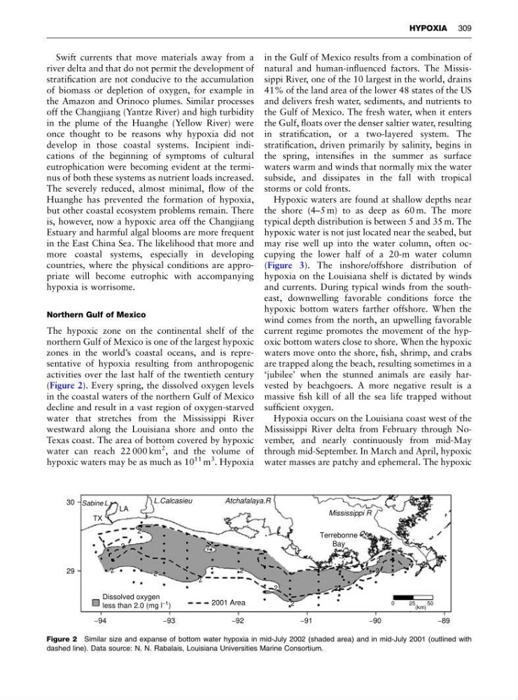
The hypoxic zone on the continental shelf of the
northern Gulf of Mexico is one of the largest hypoxic
zones in the world’s coastal oceans, and is representative of hypoxia resulting from anthropogenic
activities over the last half of the twentieth century
(Figure 2). Every spring, the dissolved oxygen levels
in the coastal waters of the northern Gulf of Mexico
decline and result in a vast region of oxygen-starved
water that stretches from the Mississippi River
westward along the Louisiana shore and onto the
Texas coast. The area of bottom covered by hypoxic
water can reach 22 000 km
2 , and the volume of
hypoxic waters may be as much as 10
11 m
3 . Hypoxia
in the Gulf of Mexico results from a combination of
natural and human-influenced factors. The Mississippi River, one of the 10 largest in the world, drains
41% of the land area of the lower 48 states of the US
and delivers fresh water, sediments, and nutrients to
the Gulf of Mexico. The fresh water, when it enters
the Gulf, floats over the denser saltier water, resulting
in stratification, or a two-layered system. The
stratification, driven primarily by salinity, begins in
the spring, intensifies in the summer as surface
waters warm and winds that normally mix the water
subside, and dissipates in the fall with tropical
storms or cold fronts.
Hypoxic waters are found at shallow depths near
the shore (4–5 m) to as deep as 60 m. The more
typical depth distribution is between 5 and 35 m. The
hypoxic water is not just located near the seabed, but
may rise well up into the water column, often occupying the lower half of a 20-m water column
(Figure 3). The inshore/offshore distribution of
hypoxia on the Louisiana shelf is dictated by winds
and currents. During typical winds from the southeast, downwelling favorable conditions force the
hypoxic bottom waters farther offshore. When the
wind comes from the north, an upwelling favorable
current regime promotes the movement of the hypoxic bottom waters close to shore. When the hypoxic
waters move onto the shore, fish, shrimp, and crabs
are trapped along the beach, resulting sometimes in a
‘jubilee’ when the stunned animals are easily harvested by beachgoers. A more negative result is a
massive fish kill of all the sea life trapped without
sufficient oxygen.
Hypoxia occurs on the Louisiana coast west of the
Mississippi River delta from February through November, and nearly continuously from mid-May
through mid-September. In March and April, hypoxic
water masses are patchy and ephemeral. The hypoxic
30
29
−94
−93
−92
2001 Area
−91
−90
−89
TX
LA
L.Calcasieu
Atchafalaya.R
Mississippi R
Dissolved oxygen
less than 2.0 (mg l
−1 )
0
25
50
(km)
Terrebonne
Bay
Sabine L.
2
2
2
2
2
2
2
2
2
2
2
2
Figure 2 Similar size and expanse of bottom water hypoxia in mid-July 2002 (shaded area) and in mid-July 2001 (outlined with
dashed line). Data source: N. N. Rabalais, Louisiana Universities Marine Consortium.
HYPOXIA 309
river delta and that do not permit the development of
stratification are not conducive to the accumulation
of biomass or depletion of oxygen, for example in
the Amazon and Orinoco plumes. Similar processes
off the Changjiang (Yantze River) and high turbidity
in the plume of the Huanghe (Yellow River) were
once thought to be reasons why hypoxia did not
develop in those coastal systems. Incipient indications of the beginning of symptoms of cultural
eutrophication were becoming evident at the terminus of both these systems as nutrient loads increased.
The severely reduced, almost minimal, flow of the
Huanghe has prevented the formation of hypoxia,
but other coastal ecosystem problems remain. There
is, however, now a hypoxic area off the Changjiang
Estuary and harmful algal blooms are more frequent
in the East China Sea. The likelihood that more and
more coastal systems, especially in developing
countries, where the physical conditions are appropriate will become eutrophic with accompanying
hypoxia is worrisome.
Northern Gulf of Mexico
The hypoxic zone on the continental shelf of the
northern Gulf of Mexico is one of the largest hypoxic
zones in the world’s coastal oceans, and is representative of hypoxia resulting from anthropogenic
activities over the last half of the twentieth century
(Figure 2). Every spring, the dissolved oxygen levels
in the coastal waters of the northern Gulf of Mexico
decline and result in a vast region of oxygen-starved
water that stretches from the Mississippi River
westward along the Louisiana shore and onto the
Texas coast. The area of bottom covered by hypoxic
water can reach 22 000 km
2 , and the volume of
hypoxic waters may be as much as 10
11 m
3 . Hypoxia
in the Gulf of Mexico results from a combination of
natural and human-influenced factors. The Mississippi River, one of the 10 largest in the world, drains
41% of the land area of the lower 48 states of the US
and delivers fresh water, sediments, and nutrients to
the Gulf of Mexico. The fresh water, when it enters
the Gulf, floats over the denser saltier water, resulting
in stratification, or a two-layered system. The
stratification, driven primarily by salinity, begins in
the spring, intensifies in the summer as surface
waters warm and winds that normally mix the water
subside, and dissipates in the fall with tropical
storms or cold fronts.
Hypoxic waters are found at shallow depths near
the shore (4–5 m) to as deep as 60 m. The more
typical depth distribution is between 5 and 35 m. The
hypoxic water is not just located near the seabed, but
may rise well up into the water column, often occupying the lower half of a 20-m water column
(Figure 3). The inshore/offshore distribution of
hypoxia on the Louisiana shelf is dictated by winds
and currents. During typical winds from the southeast, downwelling favorable conditions force the
hypoxic bottom waters farther offshore. When the
wind comes from the north, an upwelling favorable
current regime promotes the movement of the hypoxic bottom waters close to shore. When the hypoxic
waters move onto the shore, fish, shrimp, and crabs
are trapped along the beach, resulting sometimes in a
‘jubilee’ when the stunned animals are easily harvested by beachgoers. A more negative result is a
massive fish kill of all the sea life trapped without
sufficient oxygen.
Hypoxia occurs on the Louisiana coast west of the
Mississippi River delta from February through November, and nearly continuously from mid-May
through mid-September. In March and April, hypoxic
water masses are patchy and ephemeral. The hypoxic
30
29
−94
−93
−92
2001 Area
−91
−90
−89
TX
LA
L.Calcasieu
Atchafalaya.R
Mississippi R
Dissolved oxygen
less than 2.0 (mg l
−1 )
0
25
50
(km)
Terrebonne
Bay
Sabine L.
2
2
2
2
2
2
2
2
2
2
2
2
Figure 2 Similar size and expanse of bottom water hypoxia in mid-July 2002 (shaded area) and in mid-July 2001 (outlined with
dashed line). Data source: N. N. Rabalais, Louisiana Universities Marine Consortium.
HYPOXIA 309