

GEOSECS
WOCE, NOAA, Helios
2 6
?
2 6
?
3 4
EPR
2 6
1
8
1 8
18
2 6
1 0
40°N
20°N
0°
20°S
40°S
60°S
Latitude
140°E
160°E
180°
160°W
140°W
120°W
100°W
80°W
Longitude
JdFR
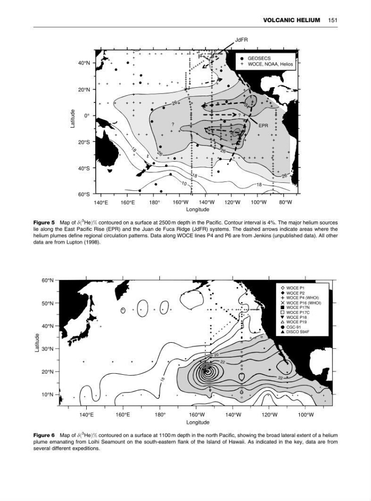
Figure 5 Map of dð
3 HeÞ% contoured on a surface at 2500 m depth in the Pacific. Contour interval is 4%. The major helium sources
lie along the East Pacific Rise (EPR) and the Juan de Fuca Ridge (JdFR) systems. The dashed arrows indicate areas where the
helium plumes define regional circulation patterns. Data along WOCE lines P4 and P6 are from Jenkins (unpublished data). All other
data are from Lupton (1998).
22
20
22
1 8
WOCE P1
WOCE P2
WOCE P4 (WHOI)
WOCE P16 (WHOI)
WOCE P17N
WOCE P17C
WOCE P19
CGC-91
DISCO S94F
WOCE P18
60°N
50°N
40°N
30°N
20°N
10°N
140°E
160°E
180°
160°W
140°W
120°W
100°W
Latitude
Longitude
Figure 6 Map of dð
3 HeÞ% contoured on a surface at 1100 m depth in the north Pacific, showing the broad lateral extent of a helium
plume emanating from Loihi Seamount on the south-eastern flank of the Island of Hawaii. As indicated in the key, data are from
several different expeditions.
VOLCANIC HELIUM 151
WOCE, NOAA, Helios
2 6
?
2 6
?
3 4
EPR
2 6
1
8
1 8
18
2 6
1 0
40°N
20°N
0°
20°S
40°S
60°S
Latitude
140°E
160°E
180°
160°W
140°W
120°W
100°W
80°W
Longitude
JdFR
Figure 5 Map of dð
3 HeÞ% contoured on a surface at 2500 m depth in the Pacific. Contour interval is 4%. The major helium sources
lie along the East Pacific Rise (EPR) and the Juan de Fuca Ridge (JdFR) systems. The dashed arrows indicate areas where the
helium plumes define regional circulation patterns. Data along WOCE lines P4 and P6 are from Jenkins (unpublished data). All other
data are from Lupton (1998).
22
20
22
1 8
WOCE P1
WOCE P2
WOCE P4 (WHOI)
WOCE P16 (WHOI)
WOCE P17N
WOCE P17C
WOCE P19
CGC-91
DISCO S94F
WOCE P18
60°N
50°N
40°N
30°N
20°N
10°N
140°E
160°E
180°
160°W
140°W
120°W
100°W
Latitude
Longitude
Figure 6 Map of dð
3 HeÞ% contoured on a surface at 1100 m depth in the north Pacific, showing the broad lateral extent of a helium
plume emanating from Loihi Seamount on the south-eastern flank of the Island of Hawaii. As indicated in the key, data are from
several different expeditions.
VOLCANIC HELIUM 151