

CoastGIS’99: geomatics and coastal environment
and communication technologies and infrastructures. In addition, GI
needs an information infrastructure to guarantee data integrity and
data exchange.
In many organizations, GI is often considered as a cost, not an asset. If
GI is only a necessity to run some technical tasks inside an organization,
it will not try to make it pay, or use it commercially.
GI is also a horizontal activity, giving it a fragmented market with
local level activity and sector specific activities. Diverse specifications,
standards and reference systems make communicating and exchanging
data very difficult between sectors and across administrative borders.
This heterogeneity also makes it difficult to assess the market.
GI is used by many public services in the framework of their duty,
contributing to improve public welfare. Although (GI commercial value
is unknown, its impact on the economy is considerable.
GI is used to manage assets worth billions of Euro: water, electricity,
gas, telephone, streets networks and many infrastructures. It can also
improve crisis management in natural hazard situations, saving lives
as well as major expenditure.
Why GI2000: some practical examples
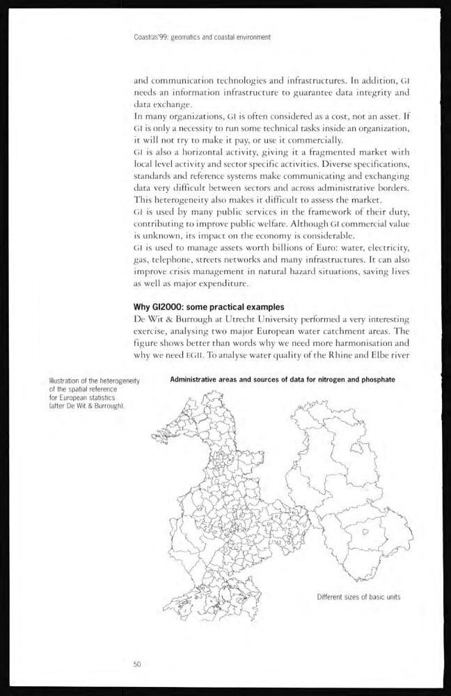
De Wit & Burrough at Utrecht University performed a very interesting
exercise, analysing two major European water catchment areas. The
figure shows better than words why we need more harmonisation and
why we need HGIL To analyse water quality of the Rhine and Elbe river
Illustration of the heterogeneity
of the spatial reference
for European statistics
(after De Wlt & Burrough).
Administrative areas and sources of data for nitrogen and phosphate
50
and communication technologies and infrastructures. In addition, GI
needs an information infrastructure to guarantee data integrity and
data exchange.
In many organizations, GI is often considered as a cost, not an asset. If
GI is only a necessity to run some technical tasks inside an organization,
it will not try to make it pay, or use it commercially.
GI is also a horizontal activity, giving it a fragmented market with
local level activity and sector specific activities. Diverse specifications,
standards and reference systems make communicating and exchanging
data very difficult between sectors and across administrative borders.
This heterogeneity also makes it difficult to assess the market.
GI is used by many public services in the framework of their duty,
contributing to improve public welfare. Although (GI commercial value
is unknown, its impact on the economy is considerable.
GI is used to manage assets worth billions of Euro: water, electricity,
gas, telephone, streets networks and many infrastructures. It can also
improve crisis management in natural hazard situations, saving lives
as well as major expenditure.
Why GI2000: some practical examples
De Wit & Burrough at Utrecht University performed a very interesting
exercise, analysing two major European water catchment areas. The
figure shows better than words why we need more harmonisation and
why we need HGIL To analyse water quality of the Rhine and Elbe river
Illustration of the heterogeneity
of the spatial reference
for European statistics
(after De Wlt & Burrough).
Administrative areas and sources of data for nitrogen and phosphate
50