

Regulatory aspects
On the other hancl, when the legislation describes the boundaries of the
marine areas using co-ordinates, it rarely indicates the datum or the reference map. Although official Spanish cartography is mainly in the
European datum 50 (ellipsoid Hayford) (ED-50) cartography also exists
in WGS-84, Madrid datum (ellipsoid Struve), pico de las Nieves datum
(Canary Islands) and Mercator, UTM and Lambert projections.
It must also be born in mind that in Spain the Central Government
legislates the area of external waters and the legal terrestrial-marine
demarcation (which does not coincide with the coast), and regional
governments legislate in the area of inland waters. There are also several
official cartographic services, the Instituto Geografico Nacional (IGNSpain), the Instituto Hidrogrâfico de la Marina (IHM), the Servicio Cartografico clel Ejército (Army Cartographic Service) and other regional
cartographic services (autonomous communities).
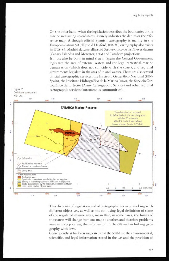
Figure 2
Definition boundaries
with GIS.
This diversity of legislation and of cartographic services working with
different objectives, as well as the confusing legal definition of some
of the regulated marine areas, mean that, in some cases, the limits of
these areas will change from one map to another, and therefore problems
arise in incorporating the information in the GIS and in linking geography with laws.
Consequently, it has been suggested that the SGPM use the environmental,
scientific, and legal information stored in the GIS and the precision of
297
On the other hancl, when the legislation describes the boundaries of the
marine areas using co-ordinates, it rarely indicates the datum or the reference map. Although official Spanish cartography is mainly in the
European datum 50 (ellipsoid Hayford) (ED-50) cartography also exists
in WGS-84, Madrid datum (ellipsoid Struve), pico de las Nieves datum
(Canary Islands) and Mercator, UTM and Lambert projections.
It must also be born in mind that in Spain the Central Government
legislates the area of external waters and the legal terrestrial-marine
demarcation (which does not coincide with the coast), and regional
governments legislate in the area of inland waters. There are also several
official cartographic services, the Instituto Geografico Nacional (IGNSpain), the Instituto Hidrogrâfico de la Marina (IHM), the Servicio Cartografico clel Ejército (Army Cartographic Service) and other regional
cartographic services (autonomous communities).
Figure 2
Definition boundaries
with GIS.
This diversity of legislation and of cartographic services working with
different objectives, as well as the confusing legal definition of some
of the regulated marine areas, mean that, in some cases, the limits of
these areas will change from one map to another, and therefore problems
arise in incorporating the information in the GIS and in linking geography with laws.
Consequently, it has been suggested that the SGPM use the environmental,
scientific, and legal information stored in the GIS and the precision of
297