

CoastGIS’99: geomatics and coastal environment
well as vertical management structure that increases the complexity. This
has resulted in a nation that is ill equipped to address the inevitable
conflicts and problems arising offshore.
Many of the ocean issues have a spatial component that can be analysed
using advanced mapping technologies, such as a Geographic Information
System (GIS). The ability to visualise regulations, laws, or management
structures can assist policy makers in understanding ocean use conflicts,
help to point out inconsistencies in national or state policy, and educate
the public on ocean issues. Many of the natural resource data are
available in map form, but US laws and regulations have not generally
contained the necessary components to adequately map their spatial
extents.
To help establish functional digital boundaries that can be used to
improve ocean management strategies, the NOAA Coastal Services
Center, working with four states in the southeastern US, has been examining existing boundaries and their spatial accuracy. This is part of an
ongoing project to develop a Web-based regionul Ocean Planning
Information System (OPIS).
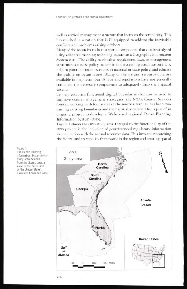
Figure 1 shows the OPIS study area. Integral to the functionality of the
OPIS project is the inclusion of georeferenced regulatory information
in conjunction with the natural resources data. This involved researching
the federal ancl state policy framework in the region and creating spatial
Figure 1
The Ocean Planning
Information System (OPIS)
study area extends
from the States coastal
zone to the outer limit
of the United State's
Exclusive Economic Zone.
286
well as vertical management structure that increases the complexity. This
has resulted in a nation that is ill equipped to address the inevitable
conflicts and problems arising offshore.
Many of the ocean issues have a spatial component that can be analysed
using advanced mapping technologies, such as a Geographic Information
System (GIS). The ability to visualise regulations, laws, or management
structures can assist policy makers in understanding ocean use conflicts,
help to point out inconsistencies in national or state policy, and educate
the public on ocean issues. Many of the natural resource data are
available in map form, but US laws and regulations have not generally
contained the necessary components to adequately map their spatial
extents.
To help establish functional digital boundaries that can be used to
improve ocean management strategies, the NOAA Coastal Services
Center, working with four states in the southeastern US, has been examining existing boundaries and their spatial accuracy. This is part of an
ongoing project to develop a Web-based regionul Ocean Planning
Information System (OPIS).
Figure 1 shows the OPIS study area. Integral to the functionality of the
OPIS project is the inclusion of georeferenced regulatory information
in conjunction with the natural resources data. This involved researching
the federal ancl state policy framework in the region and creating spatial
Figure 1
The Ocean Planning
Information System (OPIS)
study area extends
from the States coastal
zone to the outer limit
of the United State's
Exclusive Economic Zone.
286