

Environmental and resource applications
Figure 5
Average change of depth
and measurement
techniques in the shoreface
of the East Frisian Islands.
Average change of depth and measurement technique
Extensive computations covering several 1 000 km 2 of the German
Bight showed almost similar increases of depth in the shoreface for all
coastal sectors over several decades. For individual coast sectors covering
limited areas and local investigations increases of depth to the extent
found in the data may be realistic. During the research described in this
paper, results from survey campaigns of rhe shoreface area of the entire
German Bight (> 5 000 km
2 ) were processed and extensive sediment
balances were calculated. Computations resulted in a significant loss
of sediment for the entire shoreface of the German Bight. Because of
the total amount of sediment loss ( >2 200 million m 2 over a period of
20 years) and the absence of any accumulation areas within the shoreface of the German Bight, it is very likely that these results are caused
by errors in the database (Hüttemeyer et al., 1998).
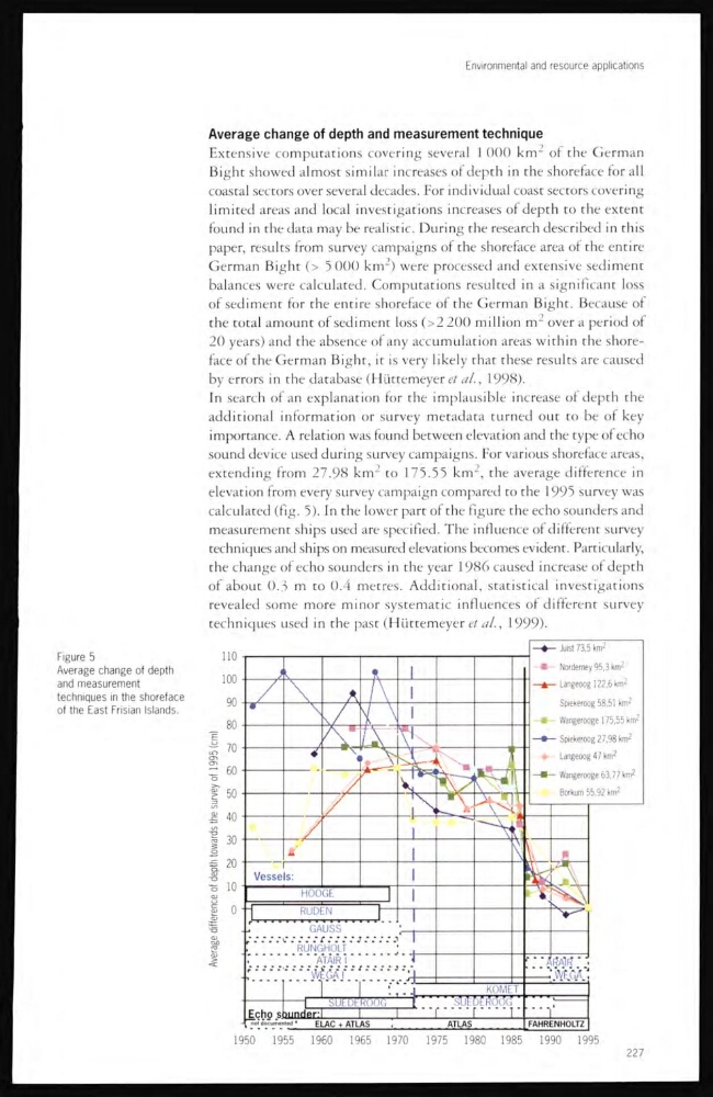
In search of an explanation for the implausible increase of deprh the
additional information or survey metadata turned out to be of key
importance. A relation was lound between elevation and the type of echo
sound device used during survey campaigns. For various shoreface areas,
extending from 27.98 km
2 to 175.55 km 2 , the average difference in
elevation from every survey campaign compared to the 1995 survey was
calculated (fig. 5). In the lower part of the figure the echo sounders and
measurement ships used are specified. The influence of different survey
techniques and ships on measured elevations becomes evident. Particularly,
the change of echo sounders in the year 1986 caused increase of depth
of about 0.3 m to 0.4 metres. Additional, statistical investigations
revealed some more minor systematic influences of different survey
techniques used in the past (Hüttemeyer et al., 1999).
227
Figure 5
Average change of depth
and measurement
techniques in the shoreface
of the East Frisian Islands.
Average change of depth and measurement technique
Extensive computations covering several 1 000 km 2 of the German
Bight showed almost similar increases of depth in the shoreface for all
coastal sectors over several decades. For individual coast sectors covering
limited areas and local investigations increases of depth to the extent
found in the data may be realistic. During the research described in this
paper, results from survey campaigns of rhe shoreface area of the entire
German Bight (> 5 000 km
2 ) were processed and extensive sediment
balances were calculated. Computations resulted in a significant loss
of sediment for the entire shoreface of the German Bight. Because of
the total amount of sediment loss ( >2 200 million m 2 over a period of
20 years) and the absence of any accumulation areas within the shoreface of the German Bight, it is very likely that these results are caused
by errors in the database (Hüttemeyer et al., 1998).
In search of an explanation for the implausible increase of deprh the
additional information or survey metadata turned out to be of key
importance. A relation was lound between elevation and the type of echo
sound device used during survey campaigns. For various shoreface areas,
extending from 27.98 km
2 to 175.55 km 2 , the average difference in
elevation from every survey campaign compared to the 1995 survey was
calculated (fig. 5). In the lower part of the figure the echo sounders and
measurement ships used are specified. The influence of different survey
techniques and ships on measured elevations becomes evident. Particularly,
the change of echo sounders in the year 1986 caused increase of depth
of about 0.3 m to 0.4 metres. Additional, statistical investigations
revealed some more minor systematic influences of different survey
techniques used in the past (Hüttemeyer et al., 1999).
227