

Environmental and resource applications
damage potential, e.g. the calculation of housing capital based on field
mappings of land use and buildings for each parcel. As a result of the
larger study areas, this is normally not practicable for meso-scale studies.
They must rely on aggregated data sets, such as statistical data, e.g.
municipal and district statistics.
For Germany, Klaus & Schmidtke ( 1990) delivered a meso-scale expert
opinion (cost-benefit analysis) for coastal defence works in the “Wesermarsch-area”, Lower Saxony. This pilot study functioned as a methodological guide for a coastal defence valuation study that was conducted
in the German Federal State of Mecklenburg-Vorpommern (Gurwell,
pers. comm.). For reasons of comparison, the same expert opinion was
used in Schleswig-Holstein.
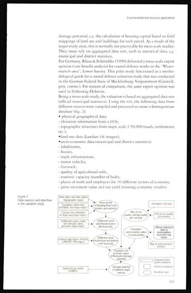
Being a meso-scale study, the valuation is based on aggregated data sets
(official municipal statistics). Using the GIS, the following data from
different sources were compiled and processed to create a homogeneous
database (fig. 2):
• physical geographical data:
- elevation information from a DTM,
- topographic structures from maps, scale 1:50,000 (roads, settlements
etc.);
•land-use data (Landsat-TM images);
•socio-economic data (municipal and district statistics):
- inhabitants,
- houses,
- roads infrastructure,
- motor vehicles,
- livestock,
- quality of agricultural soils,
- touristic capacity (number of beds),
- places of work and employees for 10 different sectors of economy,
- gross increment value and tax yield (running economic results).
Figure 2
Data sources and data flow
in the valuation study.
215
damage potential, e.g. the calculation of housing capital based on field
mappings of land use and buildings for each parcel. As a result of the
larger study areas, this is normally not practicable for meso-scale studies.
They must rely on aggregated data sets, such as statistical data, e.g.
municipal and district statistics.
For Germany, Klaus & Schmidtke ( 1990) delivered a meso-scale expert
opinion (cost-benefit analysis) for coastal defence works in the “Wesermarsch-area”, Lower Saxony. This pilot study functioned as a methodological guide for a coastal defence valuation study that was conducted
in the German Federal State of Mecklenburg-Vorpommern (Gurwell,
pers. comm.). For reasons of comparison, the same expert opinion was
used in Schleswig-Holstein.
Being a meso-scale study, the valuation is based on aggregated data sets
(official municipal statistics). Using the GIS, the following data from
different sources were compiled and processed to create a homogeneous
database (fig. 2):
• physical geographical data:
- elevation information from a DTM,
- topographic structures from maps, scale 1:50,000 (roads, settlements
etc.);
•land-use data (Landsat-TM images);
•socio-economic data (municipal and district statistics):
- inhabitants,
- houses,
- roads infrastructure,
- motor vehicles,
- livestock,
- quality of agricultural soils,
- touristic capacity (number of beds),
- places of work and employees for 10 different sectors of economy,
- gross increment value and tax yield (running economic results).
Figure 2
Data sources and data flow
in the valuation study.
215