

CoastGIS’99: geomatics and coastal environment
the proportion of ground points hit by the laser beam will be optimal,
facilitating the DTM generation even in forested areas. This particular
property of providing ground level points also in vegetation covered
areas has been one of the first aims and applications of laser scanning,
as there is no alternative technology available (Ackermann, 1997). DTMs
generated by means of laser scanning can achieve an accuracy of 15 cm
in X and Y and 10 cm in Z. As underlined by Lemmens (1997), laser
scanning technology has proven to be superior to other 3D capturing
methods, such as photogrammetry, tachymetry and terrestrial GPS,
concerning accuracy, point-density, time efficiency and cost criteria.
Laser scanning applied to Coastal Zone Management
Coastal zones in the Netherlands provide many functions for humans
and for nature. The availability or storage of fresh water is essential for
coastal ecosystems as well as for agriculture and drinking water supply.
Dune formation secures a reliable natural defence against the influence
of the sea. Interactions between land and water enable coasts to provide
excellent opportunities for economic development. Laser scanning has
been in an early age sensed as a useful tool for terrain elevation data
acquisition and for this reason much attention has been given to
develop this new technique into an operational tool.
The following will give two examples of operational laser scanning
projects applied to coastal zone management.
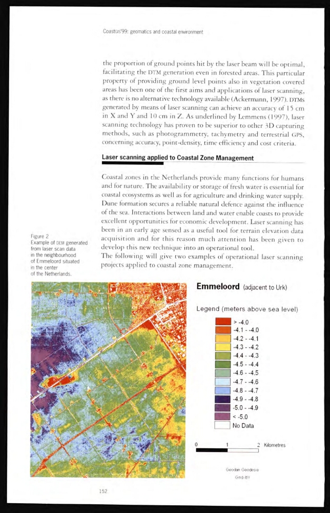
Figure 2
Example of DEM generated
from laser scan data
in the neighbourhood
of Emmeloord situated
in the center
of the Netherlands.
152
the proportion of ground points hit by the laser beam will be optimal,
facilitating the DTM generation even in forested areas. This particular
property of providing ground level points also in vegetation covered
areas has been one of the first aims and applications of laser scanning,
as there is no alternative technology available (Ackermann, 1997). DTMs
generated by means of laser scanning can achieve an accuracy of 15 cm
in X and Y and 10 cm in Z. As underlined by Lemmens (1997), laser
scanning technology has proven to be superior to other 3D capturing
methods, such as photogrammetry, tachymetry and terrestrial GPS,
concerning accuracy, point-density, time efficiency and cost criteria.
Laser scanning applied to Coastal Zone Management
Coastal zones in the Netherlands provide many functions for humans
and for nature. The availability or storage of fresh water is essential for
coastal ecosystems as well as for agriculture and drinking water supply.
Dune formation secures a reliable natural defence against the influence
of the sea. Interactions between land and water enable coasts to provide
excellent opportunities for economic development. Laser scanning has
been in an early age sensed as a useful tool for terrain elevation data
acquisition and for this reason much attention has been given to
develop this new technique into an operational tool.
The following will give two examples of operational laser scanning
projects applied to coastal zone management.
Figure 2
Example of DEM generated
from laser scan data
in the neighbourhood
of Emmeloord situated
in the center
of the Netherlands.
152