

System design and organization, access to data
Design methodology
An appropriate methodology
The design of a database for a GIS requires a methodological approach
to the problem. The most common scheme used to manage hybrid
data sets is based on a pair of databases, one for non-spatial alphanumerical data, and another reserved for spatial or geographical data.
These two data sets constitute the data aspect of the GIS. The design
of a powerful GIS database must be elaborated using reliable methodology
such as Mecosig/Congoo (Pantazis & Donnay, 1996). However, the lack
of real topological relations in the IDOD database and the high diversity
of the teams involved in the project, led to the choice of a more general
design methodology such as Merise (Nanci & Espinasse, 1996).
Following the Merise guideline, the conceptual datamodel of the database is created using the Entity/Relationship formalism. This datamodel is a static representation of the information system or of all the
data in the domain. It is designed with abstraction of the technical
aspects of the database implementation and access techniques. It refers
only to abstract objects and associations between them. The conceptual
datamodel describes these objects and associations.
Conceptual datamodel and E/R formalism
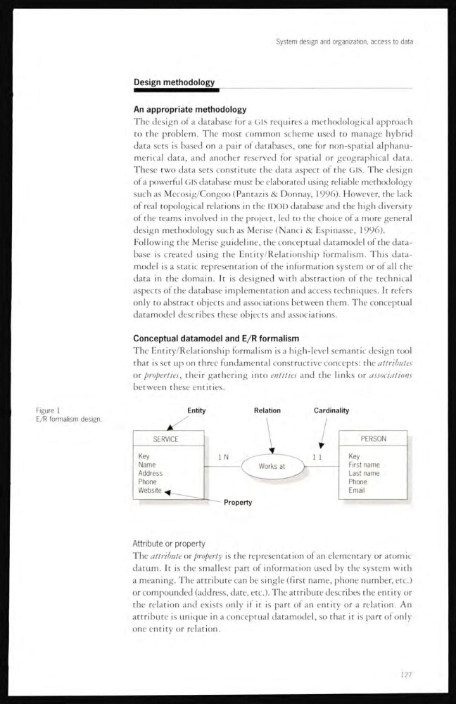
The Entity/Relationship formalism is a high-level semantic design tool
that is set up on three fundamental constructive concepts: the attnbutes
or properties, their gathering into entities and the links or associations
between these entities.
Figure 1
E/R formalism design.
Attribute or property
The attribute or property is the representation of an elementary or atomic
datum. It is the smallest part of information used by the system with
a meaning. The attribute can be single (first name, phone number, etc.)
or compounded (address, date, etc.). The attribute describes the entity or
the relation and exists only if it is part of an entity or a relation. An
attribute is unique in a conceptual datamodel, so that it is part of only
one entity or relation.
127
Design methodology
An appropriate methodology
The design of a database for a GIS requires a methodological approach
to the problem. The most common scheme used to manage hybrid
data sets is based on a pair of databases, one for non-spatial alphanumerical data, and another reserved for spatial or geographical data.
These two data sets constitute the data aspect of the GIS. The design
of a powerful GIS database must be elaborated using reliable methodology
such as Mecosig/Congoo (Pantazis & Donnay, 1996). However, the lack
of real topological relations in the IDOD database and the high diversity
of the teams involved in the project, led to the choice of a more general
design methodology such as Merise (Nanci & Espinasse, 1996).
Following the Merise guideline, the conceptual datamodel of the database is created using the Entity/Relationship formalism. This datamodel is a static representation of the information system or of all the
data in the domain. It is designed with abstraction of the technical
aspects of the database implementation and access techniques. It refers
only to abstract objects and associations between them. The conceptual
datamodel describes these objects and associations.
Conceptual datamodel and E/R formalism
The Entity/Relationship formalism is a high-level semantic design tool
that is set up on three fundamental constructive concepts: the attnbutes
or properties, their gathering into entities and the links or associations
between these entities.
Figure 1
E/R formalism design.
Attribute or property
The attribute or property is the representation of an elementary or atomic
datum. It is the smallest part of information used by the system with
a meaning. The attribute can be single (first name, phone number, etc.)
or compounded (address, date, etc.). The attribute describes the entity or
the relation and exists only if it is part of an entity or a relation. An
attribute is unique in a conceptual datamodel, so that it is part of only
one entity or relation.
127