

120
A. D. BONEY
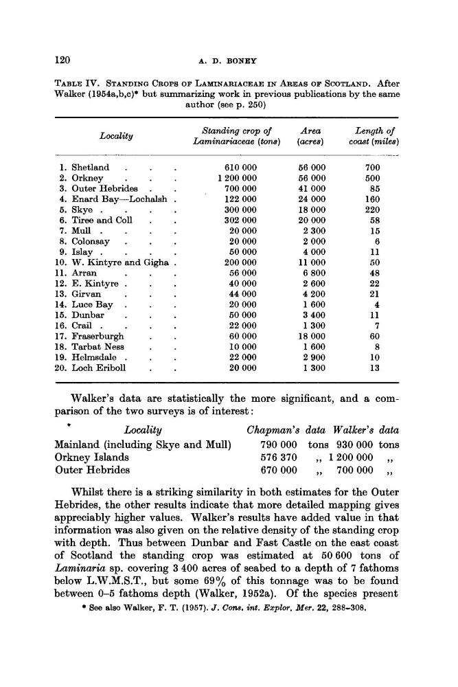
TABLE IV. STANDING CROPS OF LAMINARIACEAE IN AREAS OF SCOTLAND. After
Walker (1954a,b,c)* but summarizing work in previous publications by the same
author (see p. 250)
Standing crop of
Area
Length of
Luminariaceae (tons)
(acres)
comt (miles)
Locality
1.
2.
3.
4.
6.
6.
7.
8.
9.
10.
11.
12.
13.
14.
15.
16.
17.
18.
19.
20.
Shetland
.
Orkney
.
Outer Hebrides .
Enard Bay-Lochalsh
.
Skye .
Tiree and Coll
.
Mull .
Colonsay
.
Islay .
W. Kintyre and Gigha .
Arran
E. Kintyre .
Girvan
.
LuceBay .
Dunbar
.
Crail .
Fraserburgh
.
Tarbat Ness
Helmsdale .
Loch Eriboll
.
610 000
1200 000
700 000
122 000
300 000
302 000
20 000
20 000
50 000
200 000
56 000
40 000
44 000
20 000
60 000
22 000
60 000
10 000
22 000
20 000
56 000
56 000
41 000
24 000
18 000
20 000
2 300
2 000
4 000
11 000
6 800
2 600
4 200
1 6 0 0
3 400
1 3 0 0
18 000
1600
2 900
1300
700
500
85
160
220
58
15
6
11
50
48
22
21
4
11
7
60
8
10
13
Walker’s data are statistically the more significant, and a comLocality
Chapman’s data Walker’s data
Mainland (including Skye and Mull)
790000 tons 930000 tons
Orkney Islands
576370
,, 1200000 ,,
Outer Hebrides
670000
,, 700000 ,,
parison of the two surveys is of interest :
t
Whilst there is a striking similarity in both estimates for the Outer
Hebrides, the other results indicate that more detailed mapping gives
appreciably higher values. Walker’s results have added value in that
information was also given on the relative density of the standing crop
with depth. Thus between Dunbar and Fast Castle on the east coast
of Scotland the standing crop was estimated at 50600 tons of
Laminaria sp. covering 3 400 acres of seabed to a depth of 7 fathoms
below L.W.M.S.T., but some 69% of this tonnage was to be found
between 0-5 fathoms depth (Walker, 1952a). Of the species present
* See d e o Walker, F. T. (1957). J . Cons. int. ExpZor. Mer. 22, 288-308.
A. D. BONEY
TABLE IV. STANDING CROPS OF LAMINARIACEAE IN AREAS OF SCOTLAND. After
Walker (1954a,b,c)* but summarizing work in previous publications by the same
author (see p. 250)
Standing crop of
Area
Length of
Luminariaceae (tons)
(acres)
comt (miles)
Locality
1.
2.
3.
4.
6.
6.
7.
8.
9.
10.
11.
12.
13.
14.
15.
16.
17.
18.
19.
20.
Shetland
.
Orkney
.
Outer Hebrides .
Enard Bay-Lochalsh
.
Skye .
Tiree and Coll
.
Mull .
Colonsay
.
Islay .
W. Kintyre and Gigha .
Arran
E. Kintyre .
Girvan
.
LuceBay .
Dunbar
.
Crail .
Fraserburgh
.
Tarbat Ness
Helmsdale .
Loch Eriboll
.
610 000
1200 000
700 000
122 000
300 000
302 000
20 000
20 000
50 000
200 000
56 000
40 000
44 000
20 000
60 000
22 000
60 000
10 000
22 000
20 000
56 000
56 000
41 000
24 000
18 000
20 000
2 300
2 000
4 000
11 000
6 800
2 600
4 200
1 6 0 0
3 400
1 3 0 0
18 000
1600
2 900
1300
700
500
85
160
220
58
15
6
11
50
48
22
21
4
11
7
60
8
10
13
Walker’s data are statistically the more significant, and a comLocality
Chapman’s data Walker’s data
Mainland (including Skye and Mull)
790000 tons 930000 tons
Orkney Islands
576370
,, 1200000 ,,
Outer Hebrides
670000
,, 700000 ,,
parison of the two surveys is of interest :
t
Whilst there is a striking similarity in both estimates for the Outer
Hebrides, the other results indicate that more detailed mapping gives
appreciably higher values. Walker’s results have added value in that
information was also given on the relative density of the standing crop
with depth. Thus between Dunbar and Fast Castle on the east coast
of Scotland the standing crop was estimated at 50600 tons of
Laminaria sp. covering 3 400 acres of seabed to a depth of 7 fathoms
below L.W.M.S.T., but some 69% of this tonnage was to be found
between 0-5 fathoms depth (Walker, 1952a). Of the species present
* See d e o Walker, F. T. (1957). J . Cons. int. ExpZor. Mer. 22, 288-308.