

8
STANLEY N. DAVIS
Lake elevation
106 meters
Lines of equal water
elevation determined
from measurements
in wells
Scale
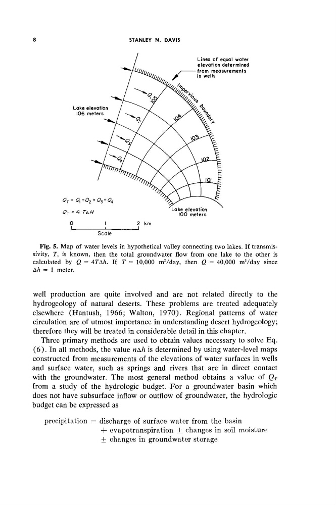
Fig. 5. Map of water levels in hypothetical valley connecting two lakes. If transmissivity, Γ, is known, then the total groundwater flow from one lake to the other is
calculated by Q = 4TAh. If T = 10,000 mVday, then Q = 40,000 mVday since
Ah = 1 meter.
well production are quite involved and are not related directly to the
hydrogeology of natural deserts. These problems are treated adequately
elsewhere (Hantush, 1966; Walton, 1970). Regional patterns of water
circulation are of utmost importance in understanding desert hydrogeology;
therefore they will be treated in considerable detail in this chapter.
Three primary methods are used to obtain values necessary to solve Eq.
(6). In all methods, the value ηΔΗ is determined by using water-level maps
constructed from measurements of the elevations of water surfaces in wells
and surface water, such as springs and rivers that are in direct contact
with the groundwater. The most general method obtains a value of Q T
from a study of the hydrologie budget. For a groundwater basin which
does not have subsurface inflow or outflow of groundwater, the hydrologie
budget can be expressed as
precipitation = discharge of surface water from the basin
+ évapotranspiration + changes in soil moisture
± changes in groundwater storage
STANLEY N. DAVIS
Lake elevation
106 meters
Lines of equal water
elevation determined
from measurements
in wells
Scale
Fig. 5. Map of water levels in hypothetical valley connecting two lakes. If transmissivity, Γ, is known, then the total groundwater flow from one lake to the other is
calculated by Q = 4TAh. If T = 10,000 mVday, then Q = 40,000 mVday since
Ah = 1 meter.
well production are quite involved and are not related directly to the
hydrogeology of natural deserts. These problems are treated adequately
elsewhere (Hantush, 1966; Walton, 1970). Regional patterns of water
circulation are of utmost importance in understanding desert hydrogeology;
therefore they will be treated in considerable detail in this chapter.
Three primary methods are used to obtain values necessary to solve Eq.
(6). In all methods, the value ηΔΗ is determined by using water-level maps
constructed from measurements of the elevations of water surfaces in wells
and surface water, such as springs and rivers that are in direct contact
with the groundwater. The most general method obtains a value of Q T
from a study of the hydrologie budget. For a groundwater basin which
does not have subsurface inflow or outflow of groundwater, the hydrologie
budget can be expressed as
precipitation = discharge of surface water from the basin
+ évapotranspiration + changes in soil moisture
± changes in groundwater storage