

528
APPENDIX B
A
B
C
OCEAN
Elevation in feet above mean sea level
0
1 mile
N
1 0 0
2 0
2
0
0
2 6 0
275
20
1 0 0
20 0
26
0
x
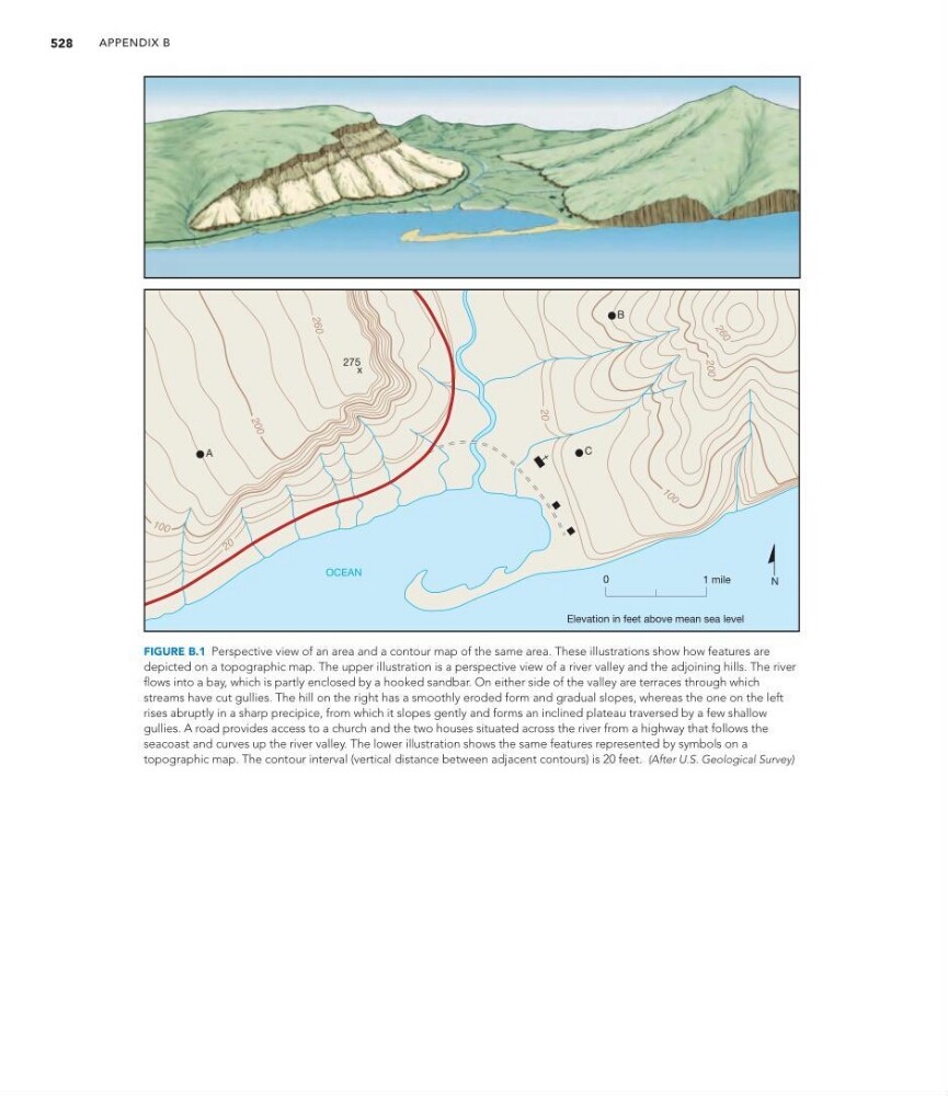
FIGURE B.1 Perspective view of an area and a contour map of the same area. These illustrations show how features are
depicted on a topographic map. The upper illustration is a perspective view of a river valley and the adjoining hills. The river
flows into a bay, which is partly enclosed by a hooked sandbar. On either side of the valley are terraces through which
streams have cut gullies. The hill on the right has a smoothly eroded form and gradual slopes, whereas the one on the left
rises abruptly in a sharp precipice, from which it slopes gently and forms an inclined plateau traversed by a few shallow
gullies. A road provides access to a church and the two houses situated across the river from a highway that follows the
seacoast and curves up the river valley. The lower illustration shows the same features represented by symbols on a
topographic map. The contour interval (vertical distance between adjacent contours) is 20 feet. (After U.S. Geological Survey)
APPENDIX B
A
B
C
OCEAN
Elevation in feet above mean sea level
0
1 mile
N
1 0 0
2 0
2
0
0
2 6 0
275
20
1 0 0
20 0
26
0
x
FIGURE B.1 Perspective view of an area and a contour map of the same area. These illustrations show how features are
depicted on a topographic map. The upper illustration is a perspective view of a river valley and the adjoining hills. The river
flows into a bay, which is partly enclosed by a hooked sandbar. On either side of the valley are terraces through which
streams have cut gullies. The hill on the right has a smoothly eroded form and gradual slopes, whereas the one on the left
rises abruptly in a sharp precipice, from which it slopes gently and forms an inclined plateau traversed by a few shallow
gullies. A road provides access to a church and the two houses situated across the river from a highway that follows the
seacoast and curves up the river valley. The lower illustration shows the same features represented by symbols on a
topographic map. The contour interval (vertical distance between adjacent contours) is 20 feet. (After U.S. Geological Survey)