

395
An Emerging Picture of the Ocean Floor
Outgoing
signal
Reflected
signal
A.
B.
Seafloor
Seafloor
Sidescan
(towfish)
Multibeam
sonar
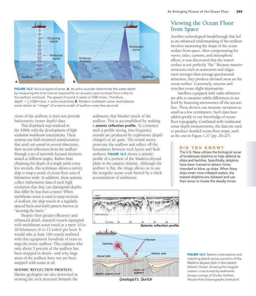
FIGURE 16.2 Various types of sonar. A. An echo sounder determines the water depth
by measuring the time interval required for an acoustic wave to travel from a ship to
the seafloor and back. The speed of sound in water is 1500 m/sec. Therefore,
B. Modern multibeam sonar and sidescan
sonar obtain an “image” of a narrow swath of seafloor every few seconds.
depth =
1
2 (1500 m/sec * echo travel time)
views of the seafloor, it does not provide
bathymetric (water depth) data.
This drawback was resolved in
the 1990s with the development of highresolution multibeam instruments. These
systems use hull-mounted sound sources
that send out sound in several directions,
then record reflections from the seafloor
through a set of narrowly focused receivers
aimed at different angles. Rather than
obtaining the depth of a single point every
few seconds, this technique allows a survey
ship to map a swath of ocean floor tens of
kilometers wide. In addition, these systems
collect bathymetric data of such high
resolution that they can distinguish depths
that differ by less than a meter. When
multibeam sonar is used to map sections
of seafloor, the ship travels in a regularly
spaced back-and-forth pattern known as
“mowing the lawn.”
Despite their greater efficiency and
enhanced detail, research vessels equipped
with multibeam sonar travel at a mere 10 to
20 kilometers (6 to 12 miles) per hour. It
would take at least 100 vessels outfitted
with this equipment hundreds of years to
map the entire seafloor. This explains why
only about 5 percent of the seafloor has
been mapped in detail—and why large
areas of the seafloor have not yet been
mapped with sonar at all.
SEISMIC REFLECTION PROFILES.
Marine geologists are also interested in
viewing the rock structure beneath the
Viewing the Ocean Floor
from Space
Another technological breakthrough that led
to an enhanced understanding of the seafloor
involves measuring the shape of the ocean
surface from space. After compensating for
waves, tides, currents, and atmospheric
effects, it was discovered that the water’ s
surface is not perfectly “flat.” Because massive
structures such as seamounts and ridges
exert stronger-than-average gravitational
attraction, they produce elevated areas on the
ocean surface. Conversely, canyons and
trenches create slight depressions.
Satellites equipped with radar altimeters
are able to measure subtle differences in sea
level by bouncing microwaves off the sea surface. These devices can measure variations as
small as a few centimeters. Such data have
added greatly to our knowledge of oceanfloor topography. Combined with traditional
sonar depth measurements, the data are used
to produce detailed ocean-floor maps, such
as the one in Figure 1.27 (pp. 26–27).
2800
3600 fathoms
0
10 miles
20
30
40
50
60
Seismic reflection profile
FIGURE 16.3 Seismic cross-section and
matching sketch across a portion of the
Madeira abyssal plain in the eastern
Atlantic Ocean, showing the irregular
oceanic crust buried by sediments.
(Image courtesy of Charles Hollister,
Woods Hole Oceanographic Institution)
D I D Y O U K N O W ?
The U.S. Navy utilizes the biological sonar
of bottlenose dolphins to help defend its
ships and facilities. Specifically, dolphins
have been trained to detect mines
intended to blow up ships. When Navy
ships enter mine-infested waters, the
trained dolphins are released and use
their sonar to locate the deadly mines.
sediments that blanket much of the
seafloor. This is accomplished by making
a seismic reflection profile. To construct
such a profile strong, low-frequency
sounds are produced by explosions (depth
charges) or air guns. The sound waves
penetrate the seafloor and reflect off the
boundaries between rock layers and fault
surfaces. FIGURE 16.3 shows a seismic
profile of a portion of the Madeira abyssal
plain in the eastern Atlantic. Although the
seafloor is flat, the image allows us to see
the irregular ocean crust buried by a thick
accumulation of sediments.
An Emerging Picture of the Ocean Floor
Outgoing
signal
Reflected
signal
A.
B.
Seafloor
Seafloor
Sidescan
(towfish)
Multibeam
sonar
FIGURE 16.2 Various types of sonar. A. An echo sounder determines the water depth
by measuring the time interval required for an acoustic wave to travel from a ship to
the seafloor and back. The speed of sound in water is 1500 m/sec. Therefore,
B. Modern multibeam sonar and sidescan
sonar obtain an “image” of a narrow swath of seafloor every few seconds.
depth =
1
2 (1500 m/sec * echo travel time)
views of the seafloor, it does not provide
bathymetric (water depth) data.
This drawback was resolved in
the 1990s with the development of highresolution multibeam instruments. These
systems use hull-mounted sound sources
that send out sound in several directions,
then record reflections from the seafloor
through a set of narrowly focused receivers
aimed at different angles. Rather than
obtaining the depth of a single point every
few seconds, this technique allows a survey
ship to map a swath of ocean floor tens of
kilometers wide. In addition, these systems
collect bathymetric data of such high
resolution that they can distinguish depths
that differ by less than a meter. When
multibeam sonar is used to map sections
of seafloor, the ship travels in a regularly
spaced back-and-forth pattern known as
“mowing the lawn.”
Despite their greater efficiency and
enhanced detail, research vessels equipped
with multibeam sonar travel at a mere 10 to
20 kilometers (6 to 12 miles) per hour. It
would take at least 100 vessels outfitted
with this equipment hundreds of years to
map the entire seafloor. This explains why
only about 5 percent of the seafloor has
been mapped in detail—and why large
areas of the seafloor have not yet been
mapped with sonar at all.
SEISMIC REFLECTION PROFILES.
Marine geologists are also interested in
viewing the rock structure beneath the
Viewing the Ocean Floor
from Space
Another technological breakthrough that led
to an enhanced understanding of the seafloor
involves measuring the shape of the ocean
surface from space. After compensating for
waves, tides, currents, and atmospheric
effects, it was discovered that the water’ s
surface is not perfectly “flat.” Because massive
structures such as seamounts and ridges
exert stronger-than-average gravitational
attraction, they produce elevated areas on the
ocean surface. Conversely, canyons and
trenches create slight depressions.
Satellites equipped with radar altimeters
are able to measure subtle differences in sea
level by bouncing microwaves off the sea surface. These devices can measure variations as
small as a few centimeters. Such data have
added greatly to our knowledge of oceanfloor topography. Combined with traditional
sonar depth measurements, the data are used
to produce detailed ocean-floor maps, such
as the one in Figure 1.27 (pp. 26–27).
2800
3600 fathoms
0
10 miles
20
30
40
50
60
Seismic reflection profile
FIGURE 16.3 Seismic cross-section and
matching sketch across a portion of the
Madeira abyssal plain in the eastern
Atlantic Ocean, showing the irregular
oceanic crust buried by sediments.
(Image courtesy of Charles Hollister,
Woods Hole Oceanographic Institution)
D I D Y O U K N O W ?
The U.S. Navy utilizes the biological sonar
of bottlenose dolphins to help defend its
ships and facilities. Specifically, dolphins
have been trained to detect mines
intended to blow up ships. When Navy
ships enter mine-infested waters, the
trained dolphins are released and use
their sonar to locate the deadly mines.
sediments that blanket much of the
seafloor. This is accomplished by making
a seismic reflection profile. To construct
such a profile strong, low-frequency
sounds are produced by explosions (depth
charges) or air guns. The sound waves
penetrate the seafloor and reflect off the
boundaries between rock layers and fault
surfaces. FIGURE 16.3 shows a seismic
profile of a portion of the Madeira abyssal
plain in the eastern Atlantic. Although the
seafloor is flat, the image allows us to see
the irregular ocean crust buried by a thick
accumulation of sediments.