

CHAPTER 15 Plate Tectonics: A Scientific Revolution Unfolds
382
“record” of the direction of the magnetic
poles at the time of their formation are said
to possess fossil magnetism, or
paleomagnetism. During the 1950s
paleomagnetic data was collected from
lava flows around the globe.
Apparent Polar Wandering
A study of rock magnetism conducted in
Europe led to an interesting discovery. The
magnetic alignment of iron-rich minerals in
lava flows of different ages indicated that
the position of the paleomagnetic poles had
changed through time. A plot of the
location of the magnetic north pole with
respect to Europe revealed that during the
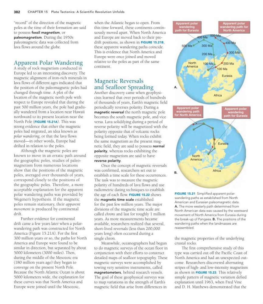
past 500 million years, the pole had gradually wandered from a location near Hawaii
northward to its present location near the
North Pole (FIGURE 15.21A). This was
strong evidence that either the magnetic
poles had migrated, an idea known as
polar wandering, or that the lava flows
moved—in other words, Europe had
drifted in relation to the poles.
Although the magnetic poles are
known to move in an erratic path around
the geographic poles, studies of paleomagnetism from numerous locations
show that the positions of the magnetic
poles, averaged over thousands of years,
correspond closely to the positions of
the geographic poles. Therefore, a more
acceptable explanation for the apparent
polar wandering paths was provided by
Wegener’ s hypothesis. If the magnetic
poles remain stationary, their apparent
movement is produced by continental
drift.
Further evidence for continental
drift came a few years later when a polarwandering path was constructed for North
America (Figure 15.21A). For the first
300 million years or so, the paths for North
America and Europe were found to be
similar in direction, but separated by about
5000 kilometers (3000 miles). Then,
during the middle of the Mesozoic era
(180 million years ago) they began to
converge on the present North Pole.
Because the North Atlantic Ocean is about
5000 kilometers wide, the explanation for
these curves was that North America and
Europe were joined until the Mesozoic,
when the Atlantic began to open. From
this time forward, these continents continuously moved apart. When North America
and Europe are moved back to their predrift positions, as shown in FIGURE 15.21B,
these apparent wandering paths coincide.
This is evidence that North America and
Europe were once joined and moved
relative to the poles as part of the same
continent.
Magnetic Reversals
and Seafloor Spreading
Another discovery came when geophysicists learned that over periods of hundreds
of thousands of years, Earth’ s magnetic field
periodically reverses polarity. During a
magnetic reversal the north magnetic pole
becomes the south magnetic pole, and vice
versa. Lava solidifying during a period of
reverse polarity will be magnetized with the
polarity opposite that of volcanic rocks
being formed today. When rocks exhibit
the same magnetism as the present magnetic field, they are said to possess normal
polarity, whereas rocks exhibiting the
opposite magnetism are said to have
reverse polarity.
Once the concept of magnetic reversals
was confirmed, researchers set out to
establish a time scale for these occurrences.
The task was to measure the magnetic
polarity of hundreds of lava flows and use
radiometric dating techniques to establish
the age of each flow. FIGURE 15.22 shows
the magnetic time scale established
for the past few million years. The major
divisions of the magnetic time scale are
called chrons and last for roughly 1 million
years. As more measurements became
available, researchers realized that several,
short-lived reversals (less than 200,000
years long) often occurred during a
single chron.
Meanwhile, oceanographers had begun
to do magnetic surveys of the ocean floor in
conjunction with their efforts to construct
detailed maps of seafloor topography. These
magnetic surveys were accomplished by
towing very sensitive instruments, called
magnetometers, behind research vessels.
The goal of these geophysical surveys was
to map variations in the strength of Earth’ s
magnetic field that arise from differences in
Apparent polar
wandering
path for Eurasia
500 Ma
500 Ma
400 Ma
300 Ma
200 Ma
100 Ma
200 Ma
100 Ma
300 Ma
Apparent polar
wandering path for
North America
North
America
Eurasia
Africa
A.
400 Ma
Apparent polar
wandering
path for Eurasia
Apparent polar
wandering path
for North America
North
America
Eurasia
Africa
B.
FIGURE 15.21 Simplified apparent polarwandering paths as established from North
American and Eurasian paleomagnetic data.
A. The more westerly path determined from
North American data was caused by the westward
movement of North America from Eurasia during
the break-up of Pangaea. B. The positions of the
wandering paths when the landmasses are
reassembled.
the magnetic properties of the underlying
crustal rocks.
The first comprehensive study of this
type was carried out off the Pacific Coast of
North America and had an unexpected outcome. Researchers discovered alternating
stripes of high- and low-intensity magnetism
as shown in FIGURE 15.23. This relatively
simple pattern of magnetic variation defied
explanation until 1963, when Fred Vine
and D. H. Matthews demonstrated that the
382
“record” of the direction of the magnetic
poles at the time of their formation are said
to possess fossil magnetism, or
paleomagnetism. During the 1950s
paleomagnetic data was collected from
lava flows around the globe.
Apparent Polar Wandering
A study of rock magnetism conducted in
Europe led to an interesting discovery. The
magnetic alignment of iron-rich minerals in
lava flows of different ages indicated that
the position of the paleomagnetic poles had
changed through time. A plot of the
location of the magnetic north pole with
respect to Europe revealed that during the
past 500 million years, the pole had gradually wandered from a location near Hawaii
northward to its present location near the
North Pole (FIGURE 15.21A). This was
strong evidence that either the magnetic
poles had migrated, an idea known as
polar wandering, or that the lava flows
moved—in other words, Europe had
drifted in relation to the poles.
Although the magnetic poles are
known to move in an erratic path around
the geographic poles, studies of paleomagnetism from numerous locations
show that the positions of the magnetic
poles, averaged over thousands of years,
correspond closely to the positions of
the geographic poles. Therefore, a more
acceptable explanation for the apparent
polar wandering paths was provided by
Wegener’ s hypothesis. If the magnetic
poles remain stationary, their apparent
movement is produced by continental
drift.
Further evidence for continental
drift came a few years later when a polarwandering path was constructed for North
America (Figure 15.21A). For the first
300 million years or so, the paths for North
America and Europe were found to be
similar in direction, but separated by about
5000 kilometers (3000 miles). Then,
during the middle of the Mesozoic era
(180 million years ago) they began to
converge on the present North Pole.
Because the North Atlantic Ocean is about
5000 kilometers wide, the explanation for
these curves was that North America and
Europe were joined until the Mesozoic,
when the Atlantic began to open. From
this time forward, these continents continuously moved apart. When North America
and Europe are moved back to their predrift positions, as shown in FIGURE 15.21B,
these apparent wandering paths coincide.
This is evidence that North America and
Europe were once joined and moved
relative to the poles as part of the same
continent.
Magnetic Reversals
and Seafloor Spreading
Another discovery came when geophysicists learned that over periods of hundreds
of thousands of years, Earth’ s magnetic field
periodically reverses polarity. During a
magnetic reversal the north magnetic pole
becomes the south magnetic pole, and vice
versa. Lava solidifying during a period of
reverse polarity will be magnetized with the
polarity opposite that of volcanic rocks
being formed today. When rocks exhibit
the same magnetism as the present magnetic field, they are said to possess normal
polarity, whereas rocks exhibiting the
opposite magnetism are said to have
reverse polarity.
Once the concept of magnetic reversals
was confirmed, researchers set out to
establish a time scale for these occurrences.
The task was to measure the magnetic
polarity of hundreds of lava flows and use
radiometric dating techniques to establish
the age of each flow. FIGURE 15.22 shows
the magnetic time scale established
for the past few million years. The major
divisions of the magnetic time scale are
called chrons and last for roughly 1 million
years. As more measurements became
available, researchers realized that several,
short-lived reversals (less than 200,000
years long) often occurred during a
single chron.
Meanwhile, oceanographers had begun
to do magnetic surveys of the ocean floor in
conjunction with their efforts to construct
detailed maps of seafloor topography. These
magnetic surveys were accomplished by
towing very sensitive instruments, called
magnetometers, behind research vessels.
The goal of these geophysical surveys was
to map variations in the strength of Earth’ s
magnetic field that arise from differences in
Apparent polar
wandering
path for Eurasia
500 Ma
500 Ma
400 Ma
300 Ma
200 Ma
100 Ma
200 Ma
100 Ma
300 Ma
Apparent polar
wandering path for
North America
North
America
Eurasia
Africa
A.
400 Ma
Apparent polar
wandering
path for Eurasia
Apparent polar
wandering path
for North America
North
America
Eurasia
Africa
B.
FIGURE 15.21 Simplified apparent polarwandering paths as established from North
American and Eurasian paleomagnetic data.
A. The more westerly path determined from
North American data was caused by the westward
movement of North America from Eurasia during
the break-up of Pangaea. B. The positions of the
wandering paths when the landmasses are
reassembled.
the magnetic properties of the underlying
crustal rocks.
The first comprehensive study of this
type was carried out off the Pacific Coast of
North America and had an unexpected outcome. Researchers discovered alternating
stripes of high- and low-intensity magnetism
as shown in FIGURE 15.23. This relatively
simple pattern of magnetic variation defied
explanation until 1963, when Fred Vine
and D. H. Matthews demonstrated that the