

Sunda megathrust, just south of the March 2005/April 2010 ruptures. Did the displacement
in 2005 transfer sufficient stress to nudge the neighboring region toward failure?
Other seismic gaps are located within the continent along the margins of the Himalayan
Mountains. One of these sites is located adjacent to the area of slippage that produced
the October 2005 Pakistan/Kashmir quake. Another is a 600-kilometer-long region on the
central Himalaya that has apparently not ruptured since 1505.
In summary, the best prospects for making useful earthquake predictions involve forecasting
magnitudes and locations on time scales of years or perhaps even decades. These forecasts are
important because they provide information that can be used in the design of structures and to
assist in land-use planning in order to reduce injuries and loss of life and property.
C O N C E P T C H E C K 1 4 . 1 0
Are accurate, short-range earthquake predictions possible using modern seismic instruments?
What is the value of long-range earthquake forecasts?
Earth’ s Interior
Earth’s Interior
Earth’s Layered Structure
If you could slice Earth in half, the first thing you would notice is that it has three distinct
layers. The heaviest materials (metals) would be in the center. Lighter solids (rocks) would
be in the middle, and liquids and gases would be on top. Within Earth we know these
layers as the iron core, the rocky mantle and crust, the liquid ocean, and the gaseous
atmosphere. More than 95 percent of the variations in composition and temperature within
Earth are due to layering. However, this is not the end of the story. If it were, Earth would
be a dead, lifeless cinder floating in space.
GEODe
ESSENTIALS
OF GEOLOGY
2
1
Central
gap
5.5 cm/year
Delhi
Calcutta
S
u
n
d
r
a
m
e
g
a
t
h
r
u
s
t
S
u
m
a
t
r
a
1905
2005
Mw 7.6
2004
Mw 9.1
2005
Mw 8.7
2010
Mw 7.8
1934
1947
1950
China
Southeast
Asia
Key
Large earthquakes since 2000
Large earthquakes between 1905–1999
Seismic gaps
A s i a n P l a t e
I n d i a n P l a t e
I n d i a n O c e a n
H i m a l a y a M o u n t a i n s
FIGURE 14.27 Seismic gaps. Map of the northern
boundary of the Indian plate, where it is moving
toward Asia. Shown in red are the rupture zones
for the three large earthquakes that have
occurred along this plate boundary since 2000.
Large earthquakes that occurred between 1905
and 1999 are shown in black, and seismic gaps are
shown in white. Seismic gaps are “quiet zones”
thought to be inactive zones that are storing
elastic strain that will eventually produce major
earthquakes.
▲ ▲ ▲ ▲ ▲
▲
▲
▲ ▲ ▲ ▲ ▲ ▲ ▲ ▲ ▲ ▲
C H I N A
PAKISTAN PAKISTAN
I N D I A
I N D I A
Tibet Plateau
Tibet Plateau
H i m a l a y a s
PAKISTAN
I N D I A
Tibet Plateau
H i m a l a y a s
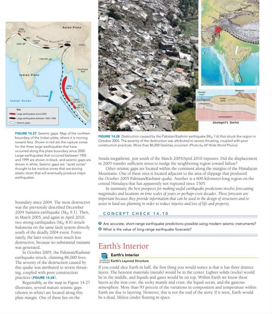
FIGURE 14.28 Destruction caused by the Pakistan/Kashmir earthquake (M W 7.6) that struck the region in
October 2005. The severity of the destruction was attributed to severe thrusting, coupled with poor
construction practices. More than 86,000 fatalities occurred. (Photo by AP Wide World Photos)
boundary since 2004. The most destructive
was the previously described December
2004 Sumatra earthquake (M W 9.1). Then,
in March 2005, and again in April 2010,
two strong earthquakes (M W 8.6) struck
Indonesia on the same fault system directly
south of the deadly 2004 event. Fortunately, the later events were much less
destructive, because no substantial tsunami
was generated.
In October 2005, the Pakistan/Kashmir
earthquake struck, claiming 86,000 lives.
The severity of the destruction caused by
this quake was attributed to severe thrusting, coupled with poor construction
practices (FIGURE 14.28).
Regrettably, as the map in Figure 14.27
illustrates, several mature seismic gaps
(shown in white) are located along this
plate margin. One of these lies on the
in 2005 transfer sufficient stress to nudge the neighboring region toward failure?
Other seismic gaps are located within the continent along the margins of the Himalayan
Mountains. One of these sites is located adjacent to the area of slippage that produced
the October 2005 Pakistan/Kashmir quake. Another is a 600-kilometer-long region on the
central Himalaya that has apparently not ruptured since 1505.
In summary, the best prospects for making useful earthquake predictions involve forecasting
magnitudes and locations on time scales of years or perhaps even decades. These forecasts are
important because they provide information that can be used in the design of structures and to
assist in land-use planning in order to reduce injuries and loss of life and property.
C O N C E P T C H E C K 1 4 . 1 0
Are accurate, short-range earthquake predictions possible using modern seismic instruments?
What is the value of long-range earthquake forecasts?
Earth’ s Interior
Earth’s Interior
Earth’s Layered Structure
If you could slice Earth in half, the first thing you would notice is that it has three distinct
layers. The heaviest materials (metals) would be in the center. Lighter solids (rocks) would
be in the middle, and liquids and gases would be on top. Within Earth we know these
layers as the iron core, the rocky mantle and crust, the liquid ocean, and the gaseous
atmosphere. More than 95 percent of the variations in composition and temperature within
Earth are due to layering. However, this is not the end of the story. If it were, Earth would
be a dead, lifeless cinder floating in space.
GEODe
ESSENTIALS
OF GEOLOGY
2
1
Central
gap
5.5 cm/year
Delhi
Calcutta
S
u
n
d
r
a
m
e
g
a
t
h
r
u
s
t
S
u
m
a
t
r
a
1905
2005
Mw 7.6
2004
Mw 9.1
2005
Mw 8.7
2010
Mw 7.8
1934
1947
1950
China
Southeast
Asia
Key
Large earthquakes since 2000
Large earthquakes between 1905–1999
Seismic gaps
A s i a n P l a t e
I n d i a n P l a t e
I n d i a n O c e a n
H i m a l a y a M o u n t a i n s
FIGURE 14.27 Seismic gaps. Map of the northern
boundary of the Indian plate, where it is moving
toward Asia. Shown in red are the rupture zones
for the three large earthquakes that have
occurred along this plate boundary since 2000.
Large earthquakes that occurred between 1905
and 1999 are shown in black, and seismic gaps are
shown in white. Seismic gaps are “quiet zones”
thought to be inactive zones that are storing
elastic strain that will eventually produce major
earthquakes.
▲ ▲ ▲ ▲ ▲
▲
▲
▲ ▲ ▲ ▲ ▲ ▲ ▲ ▲ ▲ ▲
C H I N A
PAKISTAN PAKISTAN
I N D I A
I N D I A
Tibet Plateau
Tibet Plateau
H i m a l a y a s
PAKISTAN
I N D I A
Tibet Plateau
H i m a l a y a s
FIGURE 14.28 Destruction caused by the Pakistan/Kashmir earthquake (M W 7.6) that struck the region in
October 2005. The severity of the destruction was attributed to severe thrusting, coupled with poor
construction practices. More than 86,000 fatalities occurred. (Photo by AP Wide World Photos)
boundary since 2004. The most destructive
was the previously described December
2004 Sumatra earthquake (M W 9.1). Then,
in March 2005, and again in April 2010,
two strong earthquakes (M W 8.6) struck
Indonesia on the same fault system directly
south of the deadly 2004 event. Fortunately, the later events were much less
destructive, because no substantial tsunami
was generated.
In October 2005, the Pakistan/Kashmir
earthquake struck, claiming 86,000 lives.
The severity of the destruction caused by
this quake was attributed to severe thrusting, coupled with poor construction
practices (FIGURE 14.28).
Regrettably, as the map in Figure 14.27
illustrates, several mature seismic gaps
(shown in white) are located along this
plate margin. One of these lies on the