

323
Erosion Problems along U.S. Coasts
C O N C E P T C H E C K 1 3 . 7
List at least three examples of hard stabilization and describe what each is intended
to do. How does each affect distribution of
sand on a beach?
What are two alternatives to hard stabilization and potential problems associated
with each?
Erosion Problems
along U.S. Coasts
The shoreline along the Pacific Coast of the
United States is strikingly different from
that characterizing the Atlantic and Gulf
coast regions. Some of the differences are
related to plate tectonics. The West Coast
represents the leading edge of the North
American plate, and because of this it experiences active uplift and deformation. By
contrast, the East Coast is a tectonically
quiet region that is far from any active plate
boundary. Because of this basic geological
difference the nature of shoreline erosion
problems along America’ s opposite coasts
is different.
2
1
A.
B.
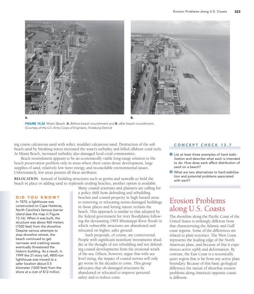
FIGURE 13.22 Miami Beach. A. Before beach nourishment and B. after beach nourishment.
(Courtesy of the U.S. Army Corps of Engineers, Vicksburg District)
ing coarse calcareous sand with softer, muddier calcareous sand. Destruction of the soft
beach sand by breaking waves increased the water’ s turbidity and killed offshore coral reefs.
At Miami Beach, increased turbidity also damaged local coral communities.
Beach nourishment appears to be an economically viable long-range solution to the
beach preservation problem only in areas where there exists dense development, large
supplies of sand, relatively low wave energy, and reconcilable environmental issues.
Unfortunately, few areas possess all these attributes.
RELOCATION. Instead of building structures such as groins and seawalls to hold the
beach in place or adding sand to replenish eroding beaches, another option is available.
Many coastal scientists and planners are calling for
a policy shift from defending and rebuilding
beaches and coastal property in high hazard areas
to removing or relocating storm-damaged buildings
in those places and letting nature reclaim the
beach. This approach is similar to that adopted by
the federal government for river floodplains following the devastating 1993 Mississippi River floods in
which vulnerable structures are abandoned and
relocated on higher, safer ground.
Such proposals, of course, are controversial.
People with significant nearshore investments shudder at the thought of not rebuilding and not defending coastal developments from the erosional wrath
of the sea. Others, however, argue that with sea
level rising, the impact of coastal storms will only
get worse in the decades to come. This group
advocates that oft-damaged structures be
abandoned or relocated to improve personal
safety and to reduce costs.
D I D Y O U K N O W ?
In 1870, a lighthouse was
constructed on Cape Hatteras,
North Carolina’s famous barrier
island (see the map in Figure
13.16). When it was built, the
structure was about 460 meters
(1500 feet) from the shoreline.
Despite various attempts to
stop shoreline retreat, the
beach continued to get
narrower and crashing waves
eventually threatened the
historic building. As a result, in
1999 the 21-story tall, 4800-ton
lighthouse was moved to a
safer location about 0.5
kilometer (1600 feet) from the
shore at a cost of $12 million.
Erosion Problems along U.S. Coasts
C O N C E P T C H E C K 1 3 . 7
List at least three examples of hard stabilization and describe what each is intended
to do. How does each affect distribution of
sand on a beach?
What are two alternatives to hard stabilization and potential problems associated
with each?
Erosion Problems
along U.S. Coasts
The shoreline along the Pacific Coast of the
United States is strikingly different from
that characterizing the Atlantic and Gulf
coast regions. Some of the differences are
related to plate tectonics. The West Coast
represents the leading edge of the North
American plate, and because of this it experiences active uplift and deformation. By
contrast, the East Coast is a tectonically
quiet region that is far from any active plate
boundary. Because of this basic geological
difference the nature of shoreline erosion
problems along America’ s opposite coasts
is different.
2
1
A.
B.
FIGURE 13.22 Miami Beach. A. Before beach nourishment and B. after beach nourishment.
(Courtesy of the U.S. Army Corps of Engineers, Vicksburg District)
ing coarse calcareous sand with softer, muddier calcareous sand. Destruction of the soft
beach sand by breaking waves increased the water’ s turbidity and killed offshore coral reefs.
At Miami Beach, increased turbidity also damaged local coral communities.
Beach nourishment appears to be an economically viable long-range solution to the
beach preservation problem only in areas where there exists dense development, large
supplies of sand, relatively low wave energy, and reconcilable environmental issues.
Unfortunately, few areas possess all these attributes.
RELOCATION. Instead of building structures such as groins and seawalls to hold the
beach in place or adding sand to replenish eroding beaches, another option is available.
Many coastal scientists and planners are calling for
a policy shift from defending and rebuilding
beaches and coastal property in high hazard areas
to removing or relocating storm-damaged buildings
in those places and letting nature reclaim the
beach. This approach is similar to that adopted by
the federal government for river floodplains following the devastating 1993 Mississippi River floods in
which vulnerable structures are abandoned and
relocated on higher, safer ground.
Such proposals, of course, are controversial.
People with significant nearshore investments shudder at the thought of not rebuilding and not defending coastal developments from the erosional wrath
of the sea. Others, however, argue that with sea
level rising, the impact of coastal storms will only
get worse in the decades to come. This group
advocates that oft-damaged structures be
abandoned or relocated to improve personal
safety and to reduce costs.
D I D Y O U K N O W ?
In 1870, a lighthouse was
constructed on Cape Hatteras,
North Carolina’s famous barrier
island (see the map in Figure
13.16). When it was built, the
structure was about 460 meters
(1500 feet) from the shoreline.
Despite various attempts to
stop shoreline retreat, the
beach continued to get
narrower and crashing waves
eventually threatened the
historic building. As a result, in
1999 the 21-story tall, 4800-ton
lighthouse was moved to a
safer location about 0.5
kilometer (1600 feet) from the
shore at a cost of $12 million.