

303
Wind Deposits
A.
B.
C.
Loess (Silt) Deposits
In some parts of the world the surface
topography is mantled with deposits
of windblown silt, called loess. Over
thousands of years dust storms deposited
this material. When loess is breached by
streams or road cuts, it tends to maintain
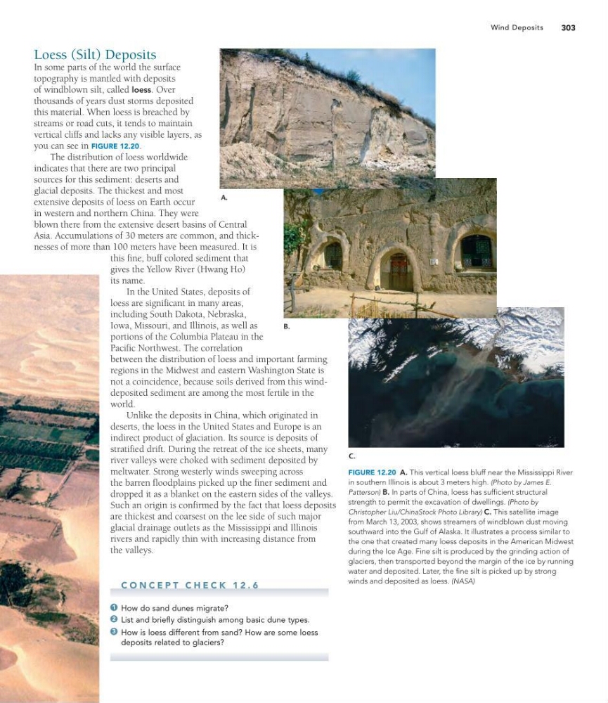
vertical cliffs and lacks any visible layers, as
you can see in FIGURE 12.20.
The distribution of loess worldwide
indicates that there are two principal
sources for this sediment: deserts and
glacial deposits. The thickest and most
extensive deposits of loess on Earth occur
in western and northern China. They were
blown there from the extensive desert basins of Central
Asia. Accumulations of 30 meters are common, and thicknesses of more than 100 meters have been measured. It is
this fine, buff colored sediment that
gives the Yellow River (Hwang Ho)
its name.
In the United States, deposits of
loess are significant in many areas,
including South Dakota, Nebraska,
Iowa, Missouri, and Illinois, as well as
portions of the Columbia Plateau in the
Pacific Northwest. The correlation
between the distribution of loess and important farming
regions in the Midwest and eastern Washington State is
not a coincidence, because soils derived from this winddeposited sediment are among the most fertile in the
world.
Unlike the deposits in China, which originated in
deserts, the loess in the United States and Europe is an
indirect product of glaciation. Its source is deposits of
stratified drift. During the retreat of the ice sheets, many
river valleys were choked with sediment deposited by
meltwater. Strong westerly winds sweeping across
the barren floodplains picked up the finer sediment and
dropped it as a blanket on the eastern sides of the valleys.
Such an origin is confirmed by the fact that loess deposits
are thickest and coarsest on the lee side of such major
glacial drainage outlets as the Mississippi and Illinois
rivers and rapidly thin with increasing distance from
the valleys.
C O N C E P T C H E C K 1 2 . 6
How do sand dunes migrate?
List and briefly distinguish among basic dune types.
How is loess different from sand? How are some loess
deposits related to glaciers?
3
2
1
FIGURE 12.20 A. This vertical loess bluff near the Mississippi River
in southern Illinois is about 3 meters high. (Photo by James E.
Patterson) B. In parts of China, loess has sufficient structural
strength to permit the excavation of dwellings. (Photo by
Christopher Liu/ChinaStock Photo Library) C. This satellite image
from March 13, 2003, shows streamers of windblown dust moving
southward into the Gulf of Alaska. It illustrates a process similar to
the one that created many loess deposits in the American Midwest
during the Ice Age. Fine silt is produced by the grinding action of
glaciers, then transported beyond the margin of the ice by running
water and deposited. Later, the fine silt is picked up by strong
winds and deposited as loess. (NASA)
Wind Deposits
A.
B.
C.
Loess (Silt) Deposits
In some parts of the world the surface
topography is mantled with deposits
of windblown silt, called loess. Over
thousands of years dust storms deposited
this material. When loess is breached by
streams or road cuts, it tends to maintain
vertical cliffs and lacks any visible layers, as
you can see in FIGURE 12.20.
The distribution of loess worldwide
indicates that there are two principal
sources for this sediment: deserts and
glacial deposits. The thickest and most
extensive deposits of loess on Earth occur
in western and northern China. They were
blown there from the extensive desert basins of Central
Asia. Accumulations of 30 meters are common, and thicknesses of more than 100 meters have been measured. It is
this fine, buff colored sediment that
gives the Yellow River (Hwang Ho)
its name.
In the United States, deposits of
loess are significant in many areas,
including South Dakota, Nebraska,
Iowa, Missouri, and Illinois, as well as
portions of the Columbia Plateau in the
Pacific Northwest. The correlation
between the distribution of loess and important farming
regions in the Midwest and eastern Washington State is
not a coincidence, because soils derived from this winddeposited sediment are among the most fertile in the
world.
Unlike the deposits in China, which originated in
deserts, the loess in the United States and Europe is an
indirect product of glaciation. Its source is deposits of
stratified drift. During the retreat of the ice sheets, many
river valleys were choked with sediment deposited by
meltwater. Strong westerly winds sweeping across
the barren floodplains picked up the finer sediment and
dropped it as a blanket on the eastern sides of the valleys.
Such an origin is confirmed by the fact that loess deposits
are thickest and coarsest on the lee side of such major
glacial drainage outlets as the Mississippi and Illinois
rivers and rapidly thin with increasing distance from
the valleys.
C O N C E P T C H E C K 1 2 . 6
How do sand dunes migrate?
List and briefly distinguish among basic dune types.
How is loess different from sand? How are some loess
deposits related to glaciers?
3
2
1
FIGURE 12.20 A. This vertical loess bluff near the Mississippi River
in southern Illinois is about 3 meters high. (Photo by James E.
Patterson) B. In parts of China, loess has sufficient structural
strength to permit the excavation of dwellings. (Photo by
Christopher Liu/ChinaStock Photo Library) C. This satellite image
from March 13, 2003, shows streamers of windblown dust moving
southward into the Gulf of Alaska. It illustrates a process similar to
the one that created many loess deposits in the American Midwest
during the Ice Age. Fine silt is produced by the grinding action of
glaciers, then transported beyond the margin of the ice by running
water and deposited. Later, the fine silt is picked up by strong
winds and deposited as loess. (NASA)