

CHAPTER 11 Glaciers and Glaciation
276
the till is dropped and the end moraine
grows. The longer the ice front remains
stable, the larger the ridge of till will
become.
Eventually the time comes when ablation exceeds nourishment. At this point,
the front of the glacier begins to recede in
the direction from which it originally
advanced. However, as the ice front
retreats, the conveyor-belt action of the glacier continues to provide fresh supplies of
sediment to the terminus. In this manner a
large quantity of till is deposited as the ice
melts away, creating a rock-strewn, undulating plain. This gently rolling layer of till
deposited as the ice front recedes is termed
ground moraine. It has a leveling effect, filling in low spots and clogging old stream
channels, often leading to a derangement
of the existing drainage system. In areas
where this layer of till is still relatively
fresh, such as the northern Great Lakes
region, poorly drained swampy lands are
quite common.
Periodically, a glacier will retreat to
a point where ablation and nourishment
once again balance. When this happens,
the ice front stabilizes and a new end
moraine forms.
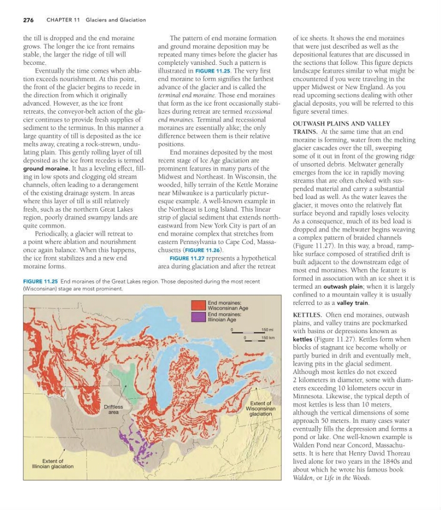
The pattern of end moraine formation
and ground moraine deposition may be
repeated many times before the glacier has
completely vanished. Such a pattern is
illustrated in FIGURE 11.25. The very first
end moraine to form signifies the farthest
advance of the glacier and is called the
terminal end moraine. Those end moraines
that form as the ice front occasionally stabilizes during retreat are termed recessional
end moraines. Terminal and recessional
moraines are essentially alike; the only
difference between them is their relative
positions.
End moraines deposited by the most
recent stage of Ice Age glaciation are
prominent features in many parts of the
Midwest and Northeast. In Wisconsin, the
wooded, hilly terrain of the Kettle Moraine
near Milwaukee is a particularly picturesque example. A well-known example in
the Northeast is Long Island. This linear
strip of glacial sediment that extends northeastward from New York City is part of an
end moraine complex that stretches from
eastern Pennsylvania to Cape Cod, Massachusetts (FIGURE 11.26).
FIGURE 11.27 represents a hypothetical
area during glaciation and after the retreat
of ice sheets. It shows the end moraines
that were just described as well as the
depositional features that are discussed in
the sections that follow. This figure depicts
landscape features similar to what might be
encountered if you were traveling in the
upper Midwest or New England. As you
read upcoming sections dealing with other
glacial deposits, you will be referred to this
figure several times.
OUTWASH PLAINS AND VALLEY
TRAINS. At the same time that an end
moraine is forming, water from the melting
glacier cascades over the till, sweeping
some of it out in front of the growing ridge
of unsorted debris. Meltwater generally
emerges from the ice in rapidly moving
streams that are often choked with suspended material and carry a substantial
bed load as well. As the water leaves the
glacier, it moves onto the relatively flat
surface beyond and rapidly loses velocity.
As a consequence, much of its bed load is
dropped and the meltwater begins weaving
a complex pattern of braided channels
(Figure 11.27). In this way, a broad, ramplike surface composed of stratified drift is
built adjacent to the downstream edge of
most end moraines. When the feature is
formed in association with an ice sheet it is
termed an outwash plain; when it is largely
confined to a mountain valley it is usually
referred to as a valley train.
KETTLES. Often end moraines, outwash
plains, and valley trains are pockmarked
with basins or depressions known as
kettles (Figure 11.27). Kettles form when
blocks of stagnant ice become wholly or
partly buried in drift and eventually melt,
leaving pits in the glacial sediment.
Although most kettles do not exceed
2 kilometers in diameter, some with diameters exceeding 10 kilometers occur in
Minnesota. Likewise, the typical depth of
most kettles is less than 10 meters,
although the vertical dimensions of some
approach 50 meters. In many cases water
eventually fills the depression and forms a
pond or lake. One well-known example is
Walden Pond near Concord, Massachusetts. It is here that Henry David Thoreau
lived alone for two years in the 1840s and
about which he wrote his famous book
Walden, or Life in the Woods.
Extent of
Illinoian glaciation
End moraines:
Illinoian Age
End moraines:
Wisconsinan Age
Extent of
Wisconsinan
glaciation
Driftless
area
0
150 mi
0
150 km
FIGURE 11.25 End moraines of the Great Lakes region. Those deposited during the most recent
(Wisconsinan) stage are most prominent.
276
the till is dropped and the end moraine
grows. The longer the ice front remains
stable, the larger the ridge of till will
become.
Eventually the time comes when ablation exceeds nourishment. At this point,
the front of the glacier begins to recede in
the direction from which it originally
advanced. However, as the ice front
retreats, the conveyor-belt action of the glacier continues to provide fresh supplies of
sediment to the terminus. In this manner a
large quantity of till is deposited as the ice
melts away, creating a rock-strewn, undulating plain. This gently rolling layer of till
deposited as the ice front recedes is termed
ground moraine. It has a leveling effect, filling in low spots and clogging old stream
channels, often leading to a derangement
of the existing drainage system. In areas
where this layer of till is still relatively
fresh, such as the northern Great Lakes
region, poorly drained swampy lands are
quite common.
Periodically, a glacier will retreat to
a point where ablation and nourishment
once again balance. When this happens,
the ice front stabilizes and a new end
moraine forms.
The pattern of end moraine formation
and ground moraine deposition may be
repeated many times before the glacier has
completely vanished. Such a pattern is
illustrated in FIGURE 11.25. The very first
end moraine to form signifies the farthest
advance of the glacier and is called the
terminal end moraine. Those end moraines
that form as the ice front occasionally stabilizes during retreat are termed recessional
end moraines. Terminal and recessional
moraines are essentially alike; the only
difference between them is their relative
positions.
End moraines deposited by the most
recent stage of Ice Age glaciation are
prominent features in many parts of the
Midwest and Northeast. In Wisconsin, the
wooded, hilly terrain of the Kettle Moraine
near Milwaukee is a particularly picturesque example. A well-known example in
the Northeast is Long Island. This linear
strip of glacial sediment that extends northeastward from New York City is part of an
end moraine complex that stretches from
eastern Pennsylvania to Cape Cod, Massachusetts (FIGURE 11.26).
FIGURE 11.27 represents a hypothetical
area during glaciation and after the retreat
of ice sheets. It shows the end moraines
that were just described as well as the
depositional features that are discussed in
the sections that follow. This figure depicts
landscape features similar to what might be
encountered if you were traveling in the
upper Midwest or New England. As you
read upcoming sections dealing with other
glacial deposits, you will be referred to this
figure several times.
OUTWASH PLAINS AND VALLEY
TRAINS. At the same time that an end
moraine is forming, water from the melting
glacier cascades over the till, sweeping
some of it out in front of the growing ridge
of unsorted debris. Meltwater generally
emerges from the ice in rapidly moving
streams that are often choked with suspended material and carry a substantial
bed load as well. As the water leaves the
glacier, it moves onto the relatively flat
surface beyond and rapidly loses velocity.
As a consequence, much of its bed load is
dropped and the meltwater begins weaving
a complex pattern of braided channels
(Figure 11.27). In this way, a broad, ramplike surface composed of stratified drift is
built adjacent to the downstream edge of
most end moraines. When the feature is
formed in association with an ice sheet it is
termed an outwash plain; when it is largely
confined to a mountain valley it is usually
referred to as a valley train.
KETTLES. Often end moraines, outwash
plains, and valley trains are pockmarked
with basins or depressions known as
kettles (Figure 11.27). Kettles form when
blocks of stagnant ice become wholly or
partly buried in drift and eventually melt,
leaving pits in the glacial sediment.
Although most kettles do not exceed
2 kilometers in diameter, some with diameters exceeding 10 kilometers occur in
Minnesota. Likewise, the typical depth of
most kettles is less than 10 meters,
although the vertical dimensions of some
approach 50 meters. In many cases water
eventually fills the depression and forms a
pond or lake. One well-known example is
Walden Pond near Concord, Massachusetts. It is here that Henry David Thoreau
lived alone for two years in the 1840s and
about which he wrote his famous book
Walden, or Life in the Woods.
Extent of
Illinoian glaciation
End moraines:
Illinoian Age
End moraines:
Wisconsinan Age
Extent of
Wisconsinan
glaciation
Driftless
area
0
150 mi
0
150 km
FIGURE 11.25 End moraines of the Great Lakes region. Those deposited during the most recent
(Wisconsinan) stage are most prominent.