

265
Formation and Movement of Glacial Ice
way. If the ice sheet were melted at a uniform rate, it
could feed (1) the Mississippi River for more than
50,000 years, (2) all the rivers in the United States for
about 17,000 years, (3) the Amazon River for approximately 5000 years, or (4) all the rivers of the world for
about 750 years.
C O N C E P T C H E C K 1 1 . 1
Where are glaciers found today, and what percentage of
Earth’s land surface do they cover?
Describe how glaciers fit into the hydrologic cycle. What
role do they play in the rock cycle?
List and briefly distinguish among four types of glaciers.
Formation and Movement
of Glacial Ice
Glaciers and Glaciation
Budget of a Glacier
Snow is the raw material from which glacial ice originates; therefore, glaciers form in areas
where more snow falls in winter than melts during the summer. Glaciers develop in the
high latitude polar realm because, even though annual snowfall totals are modest, temperatures are so low that little of the snow melts. Glaciers can form in mountains because temperatures drop with an increase in altitude. So even near the equator, glaciers may form at
elevations above about 5000 meters (16,400 feet). For example, Tanzania’ s Mount Kilimanjaro, which is located practically astride the equator at an altitude of 5895 meters (19,336
feet), has glaciers at its summit. The elevation above which snow remains throughout the
year is called the snowline. As you would expect, the elevation of the snowline varies with
latitude. Near the equator, it occurs high in the mountains, whereas in the vicinity of the
60th parallel it is at or near sea level. Before a glacier is created, snow must be converted
into glacial ice.
Glacial Ice Formation
When temperatures remain below freezing following a snowfall, the fluffy accumulation
of delicate hexagonal crystals soon changes. As air infiltrates the spaces between the
crystals, the extremities of the crystals evaporate and the water vapor
condenses near the centers of the crystals. In this manner snowflakes
become smaller, thicker, and more spherical, and the large pore spaces
disappear. By this process air is forced out and what was once light, fluffy
snow is recrystallized into a much denser mass of small grains having the
consistency of coarse sand. This granular recrystallized snow is called firn
and is commonly found making up old snowbanks near the end of winter.
As more snow is added, the pressure on the lower layers gradually
increases, compacting the ice grains at depth. Once the thickness of ice
and snow exceeds 50 meters (160 feet), the weight is sufficient to fuse
firn into a solid mass of interlocking ice crystals. Glacial ice has now
been formed.
The rate at which this transformation occurs varies. In regions where
the annual snow accumulation is great, burial is relatively rapid and snow
may turn to glacial ice in a matter of a decade or less. Where the yearly
addition of snow is less abundant, burial is slow and the transformation of
snow to glacial ice may take hundreds of years.
GEODe
ESSENTIALS
OF GEOLOGY
3
2
1
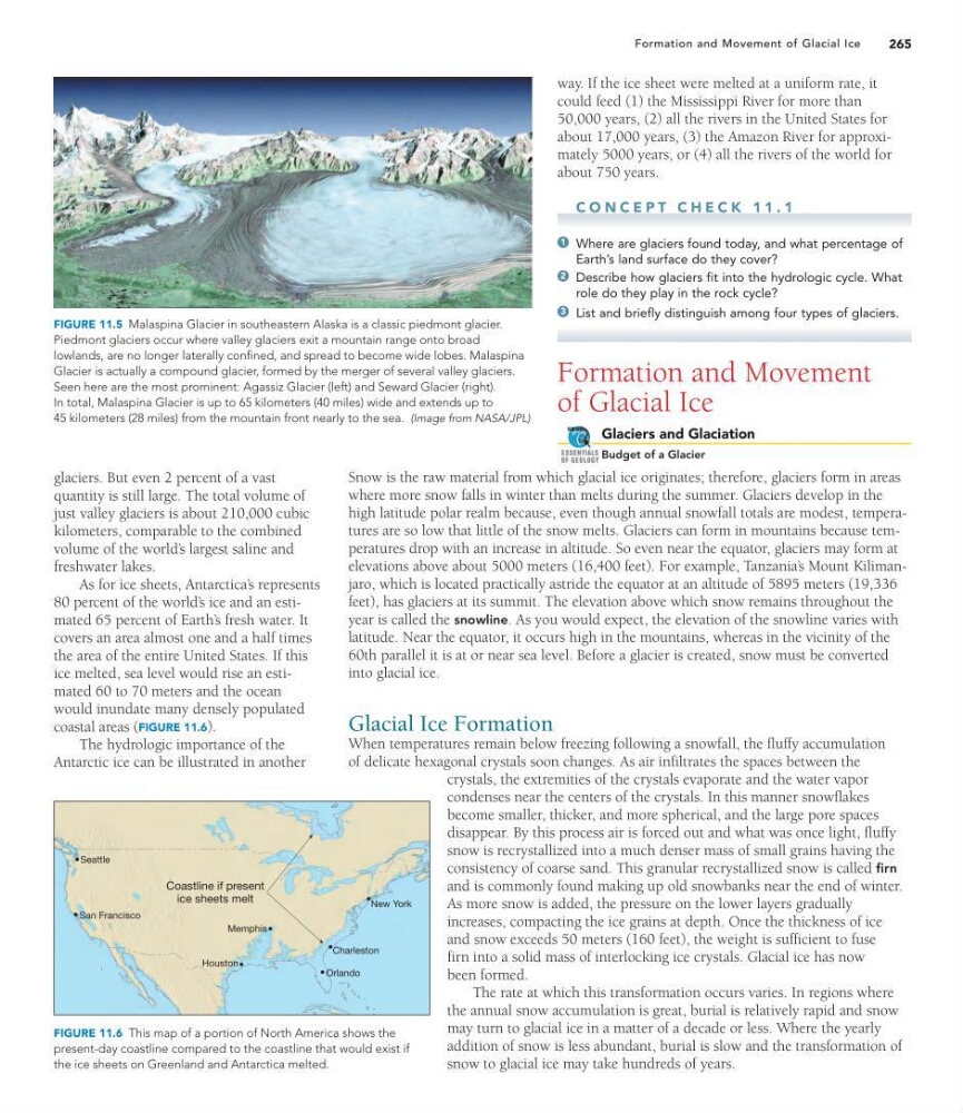
FIGURE 11.5 Malaspina Glacier in southeastern Alaska is a classic piedmont glacier.
Piedmont glaciers occur where valley glaciers exit a mountain range onto broad
lowlands, are no longer laterally confined, and spread to become wide lobes. Malaspina
Glacier is actually a compound glacier, formed by the merger of several valley glaciers.
Seen here are the most prominent: Agassiz Glacier (left) and Seward Glacier (right).
In total, Malaspina Glacier is up to 65 kilometers (40 miles) wide and extends up to
45 kilometers (28 miles) from the mountain front nearly to the sea. (Image from NASA/JPL)
San Francisco
Seattle
Houston
Memphis
Coastline if present
ice sheets melt
Orlando
Charleston
New York
FIGURE 11.6 This map of a portion of North America shows the
present-day coastline compared to the coastline that would exist if
the ice sheets on Greenland and Antarctica melted.
glaciers. But even 2 percent of a vast
quantity is still large. The total volume of
just valley glaciers is about 210,000 cubic
kilometers, comparable to the combined
volume of the world’ s largest saline and
freshwater lakes.
As for ice sheets, Antarctica’ s represents
80 percent of the world’ s ice and an estimated 65 percent of Earth’ s fresh water. It
covers an area almost one and a half times
the area of the entire United States. If this
ice melted, sea level would rise an estimated 60 to 70 meters and the ocean
would inundate many densely populated
coastal areas (FIGURE 11.6).
The hydrologic importance of the
Antarctic ice can be illustrated in another
Formation and Movement of Glacial Ice
way. If the ice sheet were melted at a uniform rate, it
could feed (1) the Mississippi River for more than
50,000 years, (2) all the rivers in the United States for
about 17,000 years, (3) the Amazon River for approximately 5000 years, or (4) all the rivers of the world for
about 750 years.
C O N C E P T C H E C K 1 1 . 1
Where are glaciers found today, and what percentage of
Earth’s land surface do they cover?
Describe how glaciers fit into the hydrologic cycle. What
role do they play in the rock cycle?
List and briefly distinguish among four types of glaciers.
Formation and Movement
of Glacial Ice
Glaciers and Glaciation
Budget of a Glacier
Snow is the raw material from which glacial ice originates; therefore, glaciers form in areas
where more snow falls in winter than melts during the summer. Glaciers develop in the
high latitude polar realm because, even though annual snowfall totals are modest, temperatures are so low that little of the snow melts. Glaciers can form in mountains because temperatures drop with an increase in altitude. So even near the equator, glaciers may form at
elevations above about 5000 meters (16,400 feet). For example, Tanzania’ s Mount Kilimanjaro, which is located practically astride the equator at an altitude of 5895 meters (19,336
feet), has glaciers at its summit. The elevation above which snow remains throughout the
year is called the snowline. As you would expect, the elevation of the snowline varies with
latitude. Near the equator, it occurs high in the mountains, whereas in the vicinity of the
60th parallel it is at or near sea level. Before a glacier is created, snow must be converted
into glacial ice.
Glacial Ice Formation
When temperatures remain below freezing following a snowfall, the fluffy accumulation
of delicate hexagonal crystals soon changes. As air infiltrates the spaces between the
crystals, the extremities of the crystals evaporate and the water vapor
condenses near the centers of the crystals. In this manner snowflakes
become smaller, thicker, and more spherical, and the large pore spaces
disappear. By this process air is forced out and what was once light, fluffy
snow is recrystallized into a much denser mass of small grains having the
consistency of coarse sand. This granular recrystallized snow is called firn
and is commonly found making up old snowbanks near the end of winter.
As more snow is added, the pressure on the lower layers gradually
increases, compacting the ice grains at depth. Once the thickness of ice
and snow exceeds 50 meters (160 feet), the weight is sufficient to fuse
firn into a solid mass of interlocking ice crystals. Glacial ice has now
been formed.
The rate at which this transformation occurs varies. In regions where
the annual snow accumulation is great, burial is relatively rapid and snow
may turn to glacial ice in a matter of a decade or less. Where the yearly
addition of snow is less abundant, burial is slow and the transformation of
snow to glacial ice may take hundreds of years.
GEODe
ESSENTIALS
OF GEOLOGY
3
2
1
FIGURE 11.5 Malaspina Glacier in southeastern Alaska is a classic piedmont glacier.
Piedmont glaciers occur where valley glaciers exit a mountain range onto broad
lowlands, are no longer laterally confined, and spread to become wide lobes. Malaspina
Glacier is actually a compound glacier, formed by the merger of several valley glaciers.
Seen here are the most prominent: Agassiz Glacier (left) and Seward Glacier (right).
In total, Malaspina Glacier is up to 65 kilometers (40 miles) wide and extends up to
45 kilometers (28 miles) from the mountain front nearly to the sea. (Image from NASA/JPL)
San Francisco
Seattle
Houston
Memphis
Coastline if present
ice sheets melt
Orlando
Charleston
New York
FIGURE 11.6 This map of a portion of North America shows the
present-day coastline compared to the coastline that would exist if
the ice sheets on Greenland and Antarctica melted.
glaciers. But even 2 percent of a vast
quantity is still large. The total volume of
just valley glaciers is about 210,000 cubic
kilometers, comparable to the combined
volume of the world’ s largest saline and
freshwater lakes.
As for ice sheets, Antarctica’ s represents
80 percent of the world’ s ice and an estimated 65 percent of Earth’ s fresh water. It
covers an area almost one and a half times
the area of the entire United States. If this
ice melted, sea level would rise an estimated 60 to 70 meters and the ocean
would inundate many densely populated
coastal areas (FIGURE 11.6).
The hydrologic importance of the
Antarctic ice can be illustrated in another