

Environmental Problems Associated
with Groundwater
As with many of our valuable natural resources, groundwater is being
exploited at an increasing rate. In some areas, overuse threatens the groundwater supply. In other places, groundwater withdrawal has caused the ground
and everything resting upon it to sink. Still other localities are concerned with
the possible contamination of their groundwater supply.
Treating Groundwater
as a Nonrenewable Resource
Many natural systems tend to establish a condition of equilibrium. The
groundwater system is no exception. The water table’ s height reflects a balance
between the rate of water added by precipitation and the rate of water
removed by discharge and withdrawal. Any imbalance will either raise or
lower the water table. A long-term drop in the water table can occur if there is
either a decrease in recharge due to a prolonged drought or an increase in
groundwater discharge or withdrawal.
For many, groundwater appears to be an endlessly renewable resource
because it is continually replenished by rainfall and melting snow. But in some
regions groundwater has been and continues to be treated as a nonrenewable
resource. Where this occurs, the water available to recharge the aquifer falls
significantly short of the amount being withdrawn.
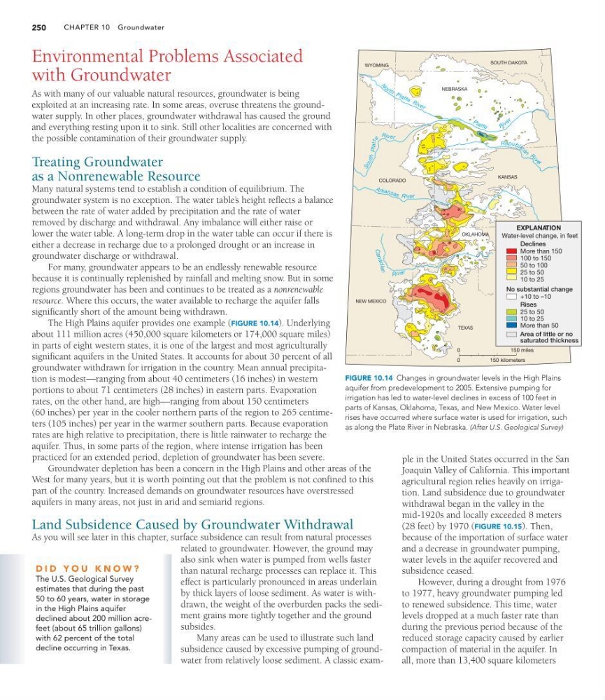
The High Plains aquifer provides one example (FIGURE 10.14). Underlying
about 111 million acres (450,000 square kilometers or 174,000 square miles)
in parts of eight western states, it is one of the largest and most agriculturally
significant aquifers in the United States. It accounts for about 30 percent of all
groundwater withdrawn for irrigation in the country. Mean annual precipitation is modest—ranging from about 40 centimeters (16 inches) in western
portions to about 71 centimeters (28 inches) in eastern parts. Evaporation
rates, on the other hand, are high—ranging from about 150 centimeters
(60 inches) per year in the cooler northern parts of the region to 265 centimeters (105 inches) per year in the warmer southern parts. Because evaporation
rates are high relative to precipitation, there is little rainwater to recharge the
aquifer. Thus, in some parts of the region, where intense irrigation has been
practiced for an extended period, depletion of groundwater has been severe.
Groundwater depletion has been a concern in the High Plains and other areas of the
West for many years, but it is worth pointing out that the problem is not confined to this
part of the country. Increased demands on groundwater resources have overstressed
aquifers in many areas, not just in arid and semiarid regions.
Land Subsidence Caused by Groundwater Withdrawal
As you will see later in this chapter, surface subsidence can result from natural processes
related to groundwater. However, the ground may
also sink when water is pumped from wells faster
than natural recharge processes can replace it. This
effect is particularly pronounced in areas underlain
by thick layers of loose sediment. As water is withdrawn, the weight of the overburden packs the sediment grains more tightly together and the ground
subsides.
Many areas can be used to illustrate such land
subsidence caused by excessive pumping of groundwater from relatively loose sediment. A classic examCHAPTER 10 Groundwater
250
WYOMING
SOUTH DAKOTA
KANSAS
COLORADO
NEBRASKA
OKLAHOMA
TEXAS
NEW MEXICO
Ca n a d ian
Ri ve r
A rk an s a s River
S o u th Platt
e
Ri ve r
N
o r t h P la tt e R iv e r
P la tt e
R iv e r
Repub li
c a
n R
i v
e r
EXPLANATION
Water-level change, in feet
Declines
No substantial change
Area of little or no
saturated thickness
Rises
More than 150
100 to 150
50 to 100
25 to 50
10 to 25
25 to 50
10 to 25
More than 50
+10 to –10
0
0
150 miles
150 kilometers
FIGURE 10.14 Changes in groundwater levels in the High Plains
aquifer from predevelopment to 2005. Extensive pumping for
irrigation has led to water-level declines in excess of 100 feet in
parts of Kansas, Oklahoma, Texas, and New Mexico. Water level
rises have occurred where surface water is used for irrigation, such
as along the Plate River in Nebraska. (After U.S. Geological Survey)
D I D Y O U K N O W ?
The U.S. Geological Survey
estimates that during the past
50 to 60 years, water in storage
in the High Plains aquifer
declined about 200 million acrefeet (about 65 trillion gallons)
with 62 percent of the total
decline occurring in Texas.
ple in the United States occurred in the San
Joaquin Valley of California. This important
agricultural region relies heavily on irrigation. Land subsidence due to groundwater
withdrawal began in the valley in the
mid-1920s and locally exceeded 8 meters
(28 feet) by 1970 (FIGURE 10.15). Then,
because of the importation of surface water
and a decrease in groundwater pumping,
water levels in the aquifer recovered and
subsidence ceased.
However, during a drought from 1976
to 1977, heavy groundwater pumping led
to renewed subsidence. This time, water
levels dropped at a much faster rate than
during the previous period because of the
reduced storage capacity caused by earlier
compaction of material in the aquifer. In
all, more than 13,400 square kilometers
with Groundwater
As with many of our valuable natural resources, groundwater is being
exploited at an increasing rate. In some areas, overuse threatens the groundwater supply. In other places, groundwater withdrawal has caused the ground
and everything resting upon it to sink. Still other localities are concerned with
the possible contamination of their groundwater supply.
Treating Groundwater
as a Nonrenewable Resource
Many natural systems tend to establish a condition of equilibrium. The
groundwater system is no exception. The water table’ s height reflects a balance
between the rate of water added by precipitation and the rate of water
removed by discharge and withdrawal. Any imbalance will either raise or
lower the water table. A long-term drop in the water table can occur if there is
either a decrease in recharge due to a prolonged drought or an increase in
groundwater discharge or withdrawal.
For many, groundwater appears to be an endlessly renewable resource
because it is continually replenished by rainfall and melting snow. But in some
regions groundwater has been and continues to be treated as a nonrenewable
resource. Where this occurs, the water available to recharge the aquifer falls
significantly short of the amount being withdrawn.
The High Plains aquifer provides one example (FIGURE 10.14). Underlying
about 111 million acres (450,000 square kilometers or 174,000 square miles)
in parts of eight western states, it is one of the largest and most agriculturally
significant aquifers in the United States. It accounts for about 30 percent of all
groundwater withdrawn for irrigation in the country. Mean annual precipitation is modest—ranging from about 40 centimeters (16 inches) in western
portions to about 71 centimeters (28 inches) in eastern parts. Evaporation
rates, on the other hand, are high—ranging from about 150 centimeters
(60 inches) per year in the cooler northern parts of the region to 265 centimeters (105 inches) per year in the warmer southern parts. Because evaporation
rates are high relative to precipitation, there is little rainwater to recharge the
aquifer. Thus, in some parts of the region, where intense irrigation has been
practiced for an extended period, depletion of groundwater has been severe.
Groundwater depletion has been a concern in the High Plains and other areas of the
West for many years, but it is worth pointing out that the problem is not confined to this
part of the country. Increased demands on groundwater resources have overstressed
aquifers in many areas, not just in arid and semiarid regions.
Land Subsidence Caused by Groundwater Withdrawal
As you will see later in this chapter, surface subsidence can result from natural processes
related to groundwater. However, the ground may
also sink when water is pumped from wells faster
than natural recharge processes can replace it. This
effect is particularly pronounced in areas underlain
by thick layers of loose sediment. As water is withdrawn, the weight of the overburden packs the sediment grains more tightly together and the ground
subsides.
Many areas can be used to illustrate such land
subsidence caused by excessive pumping of groundwater from relatively loose sediment. A classic examCHAPTER 10 Groundwater
250
WYOMING
SOUTH DAKOTA
KANSAS
COLORADO
NEBRASKA
OKLAHOMA
TEXAS
NEW MEXICO
Ca n a d ian
Ri ve r
A rk an s a s River
S o u th Platt
e
Ri ve r
N
o r t h P la tt e R iv e r
P la tt e
R iv e r
Repub li
c a
n R
i v
e r
EXPLANATION
Water-level change, in feet
Declines
No substantial change
Area of little or no
saturated thickness
Rises
More than 150
100 to 150
50 to 100
25 to 50
10 to 25
25 to 50
10 to 25
More than 50
+10 to –10
0
0
150 miles
150 kilometers
FIGURE 10.14 Changes in groundwater levels in the High Plains
aquifer from predevelopment to 2005. Extensive pumping for
irrigation has led to water-level declines in excess of 100 feet in
parts of Kansas, Oklahoma, Texas, and New Mexico. Water level
rises have occurred where surface water is used for irrigation, such
as along the Plate River in Nebraska. (After U.S. Geological Survey)
D I D Y O U K N O W ?
The U.S. Geological Survey
estimates that during the past
50 to 60 years, water in storage
in the High Plains aquifer
declined about 200 million acrefeet (about 65 trillion gallons)
with 62 percent of the total
decline occurring in Texas.
ple in the United States occurred in the San
Joaquin Valley of California. This important
agricultural region relies heavily on irrigation. Land subsidence due to groundwater
withdrawal began in the valley in the
mid-1920s and locally exceeded 8 meters
(28 feet) by 1970 (FIGURE 10.15). Then,
because of the importation of surface water
and a decrease in groundwater pumping,
water levels in the aquifer recovered and
subsidence ceased.
However, during a drought from 1976
to 1977, heavy groundwater pumping led
to renewed subsidence. This time, water
levels dropped at a much faster rate than
during the previous period because of the
reduced storage capacity caused by earlier
compaction of material in the aquifer. In
all, more than 13,400 square kilometers