

494
10 SEDIMENTARY BASINS
\
_/
Vosges///~8") / Block
A .... ~-----~
B
t IOOkmj
/k C
~/~
Rift valley fill
II VolcanJcs
Rhi ne
Valley
I I
A
,~
B
Lake
Baikal
5 km
C
.....
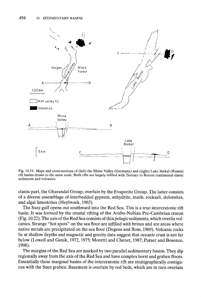
]~'--"--Fig. 10.19. Maps and cross-sections of (left) the Rhine Valley (Germany) and (right) Lake Baikal (Russia)
rift basins drawn to the same scale. Both rifts are largely infilled with Tertiary to Recent continental clastic
sediments and volcanics.
clastic part, the Gharandal Group, overlain by the Evaporite Group. The latter consists
of a diverse assemblage of interbedded gypsum, anhydrite, marls, rocksalt, dolomites,
and algal limestones (Heybroek, 1965).
The Suez gulf opens out southward into the Red Sea. This is a true intercratonic rift
basin. It was formed by the crustal rifting of the Arabo-Nubian Pre-Cambrian craton
(Fig. 10.22). The axis of the Red Sea consists of thin pelagic sediments, which overlie volcanics. Strange "hot spots" on the sea floor are infilled with brines and are areas where
native metals are precipitated on the sea floor (Degens and Ross, 1969). Volcanic rocks
lie at shallow depths and magnetic and gravity data suggest that oceanic crust is not far
below (Lowell and Genik, 1972, 1975; Moretti and Chenet, 1987; Purser and Bosence,
1998).
The margins of the Red Sea are marked by two parallel sedimentary basins. They dip
regionally away from the axis of the Red Sea and have complex horst and graben floors.
Essentially these marginal basins of the intercratonic rift are stratigraphically contiguous with the Suez graben. Basement is overlain by red beds, which are in turn overlain
10 SEDIMENTARY BASINS
\
_/
Vosges///~8") / Block
A .... ~-----~
B
t IOOkmj
/k C
~/~
Rift valley fill
II VolcanJcs
Rhi ne
Valley
I I
A
,~
B
Lake
Baikal
5 km
C
.....
]~'--"--Fig. 10.19. Maps and cross-sections of (left) the Rhine Valley (Germany) and (right) Lake Baikal (Russia)
rift basins drawn to the same scale. Both rifts are largely infilled with Tertiary to Recent continental clastic
sediments and volcanics.
clastic part, the Gharandal Group, overlain by the Evaporite Group. The latter consists
of a diverse assemblage of interbedded gypsum, anhydrite, marls, rocksalt, dolomites,
and algal limestones (Heybroek, 1965).
The Suez gulf opens out southward into the Red Sea. This is a true intercratonic rift
basin. It was formed by the crustal rifting of the Arabo-Nubian Pre-Cambrian craton
(Fig. 10.22). The axis of the Red Sea consists of thin pelagic sediments, which overlie volcanics. Strange "hot spots" on the sea floor are infilled with brines and are areas where
native metals are precipitated on the sea floor (Degens and Ross, 1969). Volcanic rocks
lie at shallow depths and magnetic and gravity data suggest that oceanic crust is not far
below (Lowell and Genik, 1972, 1975; Moretti and Chenet, 1987; Purser and Bosence,
1998).
The margins of the Red Sea are marked by two parallel sedimentary basins. They dip
regionally away from the axis of the Red Sea and have complex horst and graben floors.
Essentially these marginal basins of the intercratonic rift are stratigraphically contiguous with the Suez graben. Basement is overlain by red beds, which are in turn overlain