

482
10 SEDIMENTARY BASINS
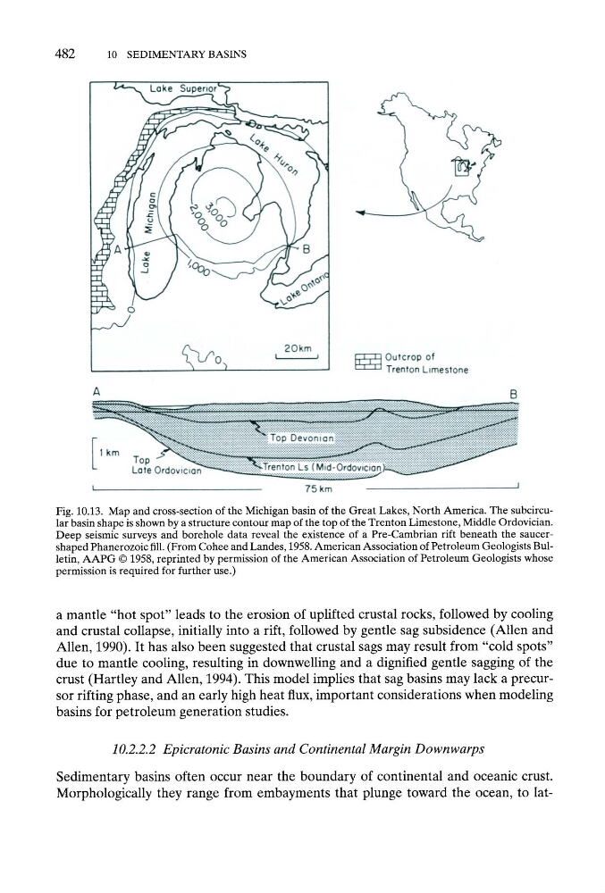
Fig. 10.13. Map and cross-section of the Michigan basin of the Great Lakes, North America. The subcircular basin shape is shown by a structure contour map of the top of the Trenton Limestone, Middle Ordovician.
Deep seismic surveys and borehole data reveal the existence of a Pre-Cambrian rift beneath the saucershaped Phanerozoic fill. (From Cohee and Landes, 1958. American Association of Petroleum Geologists Bulletin, A A P G 9 1958, reprinted by permission of the American Association of Petroleum Geologists whose
permission is required for further use.)
a mantle "hot spot" leads to the erosion of uplifted crustal rocks, followed by cooling
and crustal collapse, initially into a rift, followed by gentle sag subsidence (Allen and
Allen, 1990). It has also been suggested that crustal sags may result from "cold spots"
due to mantle cooling, resulting in downwelling and a dignified gentle sagging of the
crust (Hartley and Allen, 1994). This model implies that sag basins may lack a precursor rifling phase, and an early high heat flux, important considerations when modeling
basins for petroleum generation studies.
10.2.2.2 Epicratonic Basins and Continental Margin Downwarps
Sedimentary basins often occur near the boundary of continental and oceanic crust.
Morphologically they range from embayments that plunge toward the ocean, to lat-
10 SEDIMENTARY BASINS
Fig. 10.13. Map and cross-section of the Michigan basin of the Great Lakes, North America. The subcircular basin shape is shown by a structure contour map of the top of the Trenton Limestone, Middle Ordovician.
Deep seismic surveys and borehole data reveal the existence of a Pre-Cambrian rift beneath the saucershaped Phanerozoic fill. (From Cohee and Landes, 1958. American Association of Petroleum Geologists Bulletin, A A P G 9 1958, reprinted by permission of the American Association of Petroleum Geologists whose
permission is required for further use.)
a mantle "hot spot" leads to the erosion of uplifted crustal rocks, followed by cooling
and crustal collapse, initially into a rift, followed by gentle sag subsidence (Allen and
Allen, 1990). It has also been suggested that crustal sags may result from "cold spots"
due to mantle cooling, resulting in downwelling and a dignified gentle sagging of the
crust (Hartley and Allen, 1994). This model implies that sag basins may lack a precursor rifling phase, and an early high heat flux, important considerations when modeling
basins for petroleum generation studies.
10.2.2.2 Epicratonic Basins and Continental Margin Downwarps
Sedimentary basins often occur near the boundary of continental and oceanic crust.
Morphologically they range from embayments that plunge toward the ocean, to lat-