

478
10 SEDIMENTARY BASINS
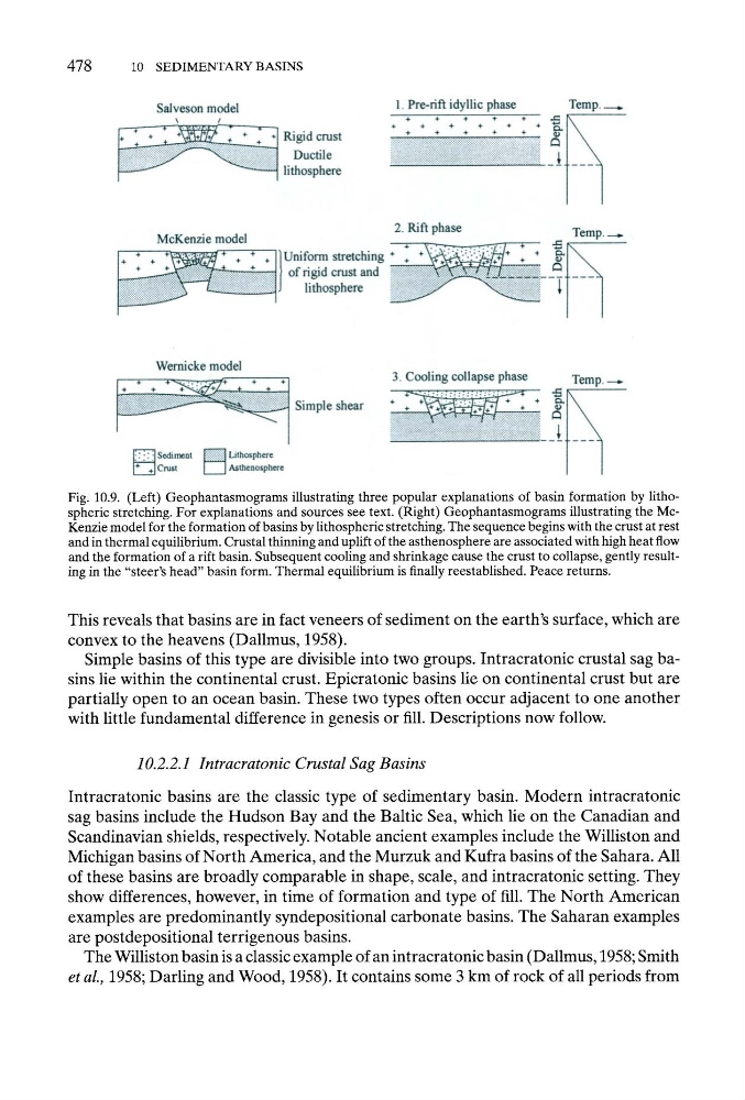
Fig. 10.9. (Left) Geophantasmograms illustrating three popular explanations of basin formation by lithospheric stretching. For explanations and sources see text. (Right) Geophantasmograms illustrating the McKenzie model for the formation of basins by lithospheric stretching. The sequence begins with the crust at rest
and in thermal equilibrium. Crustal thinning and uplift of the asthenosphere are associated with high heat flow
and the formation of a rift basin. Subsequent cooling and shrinkage cause the crust to collapse, gently resulting in the "steer's head" basin form. Thermal equilibrium is finally reestablished. Peace returns.
This reveals that basins are in fact veneers of sediment on the earth's surface, which are
convex to the heavens (Dallmus, 1958).
Simple basins of this type are divisible into two groups. Intracratonic crustal sag basins lie within the continental crust. Epicratonic basins lie on continental crust but are
partially open to an ocean basin. These two types often occur adjacent to one another
with little fundamental difference in genesis or fill. Descriptions now follow.
10.2.2.1 Intracratonic Crustal Sag Basins
Intracratonic basins are the classic type of sedimentary basin. Modern intracratonic
sag basins include the Hudson Bay and the Baltic Sea, which lie on the Canadian and
Scandinavian shields, respectively. Notable ancient examples include the Williston and
Michigan basins of North America, and the Murzuk and Kufra basins of the Sahara. All
of these basins are broadly comparable in shape, scale, and intracratonic setting. They
show differences, however, in time of formation and type of fill. The North American
examples are predominantly syndepositional carbonate basins. The Saharan examples
are postdepositional terrigenous basins.
The Williston basin is a classic example of an intracratonic basin (Dallmus, 1958; Smith
et al., 1958; Darling and Wood, 1958). It contains some 3 km of rock of all periods from
10 SEDIMENTARY BASINS
Fig. 10.9. (Left) Geophantasmograms illustrating three popular explanations of basin formation by lithospheric stretching. For explanations and sources see text. (Right) Geophantasmograms illustrating the McKenzie model for the formation of basins by lithospheric stretching. The sequence begins with the crust at rest
and in thermal equilibrium. Crustal thinning and uplift of the asthenosphere are associated with high heat flow
and the formation of a rift basin. Subsequent cooling and shrinkage cause the crust to collapse, gently resulting in the "steer's head" basin form. Thermal equilibrium is finally reestablished. Peace returns.
This reveals that basins are in fact veneers of sediment on the earth's surface, which are
convex to the heavens (Dallmus, 1958).
Simple basins of this type are divisible into two groups. Intracratonic crustal sag basins lie within the continental crust. Epicratonic basins lie on continental crust but are
partially open to an ocean basin. These two types often occur adjacent to one another
with little fundamental difference in genesis or fill. Descriptions now follow.
10.2.2.1 Intracratonic Crustal Sag Basins
Intracratonic basins are the classic type of sedimentary basin. Modern intracratonic
sag basins include the Hudson Bay and the Baltic Sea, which lie on the Canadian and
Scandinavian shields, respectively. Notable ancient examples include the Williston and
Michigan basins of North America, and the Murzuk and Kufra basins of the Sahara. All
of these basins are broadly comparable in shape, scale, and intracratonic setting. They
show differences, however, in time of formation and type of fill. The North American
examples are predominantly syndepositional carbonate basins. The Saharan examples
are postdepositional terrigenous basins.
The Williston basin is a classic example of an intracratonic basin (Dallmus, 1958; Smith
et al., 1958; Darling and Wood, 1958). It contains some 3 km of rock of all periods from