

470
10 SEDIMENTARY BASINS
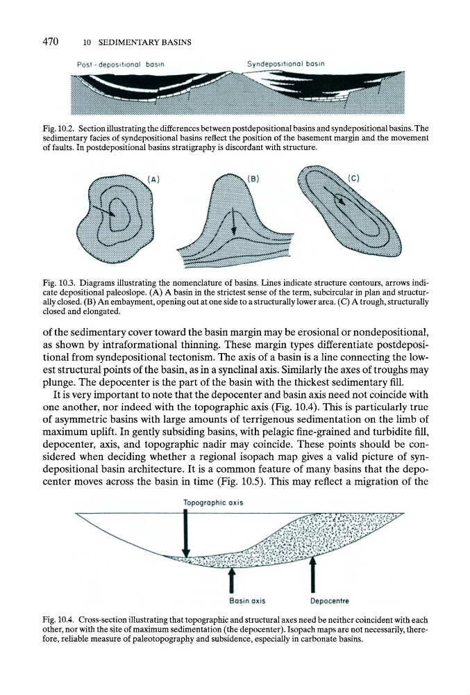
Fig. 10.2. Section illustrating the differences between postdepositional basins and syndepositional basins. The
sedimentary facies of syndepositional basins reflect the position of the basement margin and the movement
of faults. In postdepositional basins stratigraphy is discordant with structure.
Fig. 10.3. Diagrams illustrating the nomenclature of basins. Lines indicate structure contours, arrows indicate depositional paleoslope. (A) A basin in the strictest sense of the term, subcircular in plan and structurally closed. (B) An embayment, opening out at one side to a structurally lower area. (C) A trough, structurally
closed and elongated.
of the sedimentary cover toward the basin margin may be erosional or nondepositional,
as shown by intraformational thinning. These margin types differentiate postdepositional from syndepositional tectonism. The axis of a basin is a line connecting the lowest structural points of the basin, as in a synclinal axis. Similarly the axes of troughs may
plunge. The depocenter is the part of the basin with the thickest sedimentary fill.
It is very important to note that the depocenter and basin axis need not coincide with
one another, nor indeed with the topographic axis (Fig. 10.4). This is particularly true
of asymmetric basins with large amounts of terrigenous sedimentation on the limb of
maximum uplift. In gently subsiding basins, with pelagic fine-grained and turbidite fill,
depocenter, axis, and topographic nadir may coincide. These points should be considered when deciding whether a regional isopach map gives a valid picture of syndepositional basin architecture. It is a common feature of many basins that the depocenter moves across the basin in time (Fig. 10.5). This may reflect a migration of the
Fig. 10.4. Cross-section illustrating that topographic and structural axes need be neither coincident with each
other, nor with the site of maximum sedimentation (the depocenter). Isopach maps are not necessarily, therefore, reliable measure of paleotopography and subsidence, especially in carbonate basins.
10 SEDIMENTARY BASINS
Fig. 10.2. Section illustrating the differences between postdepositional basins and syndepositional basins. The
sedimentary facies of syndepositional basins reflect the position of the basement margin and the movement
of faults. In postdepositional basins stratigraphy is discordant with structure.
Fig. 10.3. Diagrams illustrating the nomenclature of basins. Lines indicate structure contours, arrows indicate depositional paleoslope. (A) A basin in the strictest sense of the term, subcircular in plan and structurally closed. (B) An embayment, opening out at one side to a structurally lower area. (C) A trough, structurally
closed and elongated.
of the sedimentary cover toward the basin margin may be erosional or nondepositional,
as shown by intraformational thinning. These margin types differentiate postdepositional from syndepositional tectonism. The axis of a basin is a line connecting the lowest structural points of the basin, as in a synclinal axis. Similarly the axes of troughs may
plunge. The depocenter is the part of the basin with the thickest sedimentary fill.
It is very important to note that the depocenter and basin axis need not coincide with
one another, nor indeed with the topographic axis (Fig. 10.4). This is particularly true
of asymmetric basins with large amounts of terrigenous sedimentation on the limb of
maximum uplift. In gently subsiding basins, with pelagic fine-grained and turbidite fill,
depocenter, axis, and topographic nadir may coincide. These points should be considered when deciding whether a regional isopach map gives a valid picture of syndepositional basin architecture. It is a common feature of many basins that the depocenter moves across the basin in time (Fig. 10.5). This may reflect a migration of the
Fig. 10.4. Cross-section illustrating that topographic and structural axes need be neither coincident with each
other, nor with the site of maximum sedimentation (the depocenter). Isopach maps are not necessarily, therefore, reliable measure of paleotopography and subsidence, especially in carbonate basins.