

9.3 COAL
431
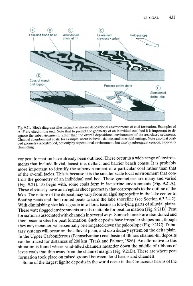
Fig. 9.21. Block diagrams illustrating the diverse depositional environments of coal formation. Examples of
A - F are cited in the text. Note that to predict the geometry of an individual coal bed it is important to diagnose the subenvironment, rather than the overall depositional environment of the associated sediments.
Channel abandonment coals, for example, occur in fluvial, deltaic, and intertidal settings. Note also that coalbed geometry is controlled, not only by depositional environment, but also by subsequent erosion, especially
channeling.
vor peat formation have already been outlined. These occur in a wide range of environments that include fluvial, lacustrine, deltaic, and barrier beach coasts. It is probably
more important to identify the subenvironment of a particular coal rather than that
of the overall facies. This is because it is the smaller scale local environment that controls the geometry of an individual coal bed. These geometries are many and varied
(Fig. 9.21). To begin with, some coals form in lacustrine environments (Fig. 9.21A).
These obviously have an irregular sheet geometry that corresponds to the outline of the
lake. The nature of the deposit may vary from an algal sapropelite in the lake center to
floating peats and then rooted peats toward the lake shoreline (see Section 6.3.2.4.2).
With diminishing size lakes grade into flood basins in low-lying parts of alluvial plains.
These waterlogged environments are also suitable for peat formation (Fig. 9.21B). Peat
formation is associated with channels in several ways. Some channels are abandoned and
then become sites for peat formation. Such deposits have irregular shapes and, though
they may meander, will essentially be elongated down the paleoslope (Fig. 9.21C). Tributary systems will occur on the alluvial plain, and distributary system on the delta plain.
In the Upper Carboniferous (Pennsylvanian) coal basin of Illinois channel-fill deposits
can be traced for distances of 200 km (Trask and Palmer, 1986). An alternative to this
situation is found where sand-filled channels meander down the middle of ribbons of
levee coals that thin away from the channel margin (Fig. 9.21D). These are where peat
formation took place on raised ground between flood basins and channels.
Some of the largest lignite deposits in the world occur in the Cretaceous basins of the
431
Fig. 9.21. Block diagrams illustrating the diverse depositional environments of coal formation. Examples of
A - F are cited in the text. Note that to predict the geometry of an individual coal bed it is important to diagnose the subenvironment, rather than the overall depositional environment of the associated sediments.
Channel abandonment coals, for example, occur in fluvial, deltaic, and intertidal settings. Note also that coalbed geometry is controlled, not only by depositional environment, but also by subsequent erosion, especially
channeling.
vor peat formation have already been outlined. These occur in a wide range of environments that include fluvial, lacustrine, deltaic, and barrier beach coasts. It is probably
more important to identify the subenvironment of a particular coal rather than that
of the overall facies. This is because it is the smaller scale local environment that controls the geometry of an individual coal bed. These geometries are many and varied
(Fig. 9.21). To begin with, some coals form in lacustrine environments (Fig. 9.21A).
These obviously have an irregular sheet geometry that corresponds to the outline of the
lake. The nature of the deposit may vary from an algal sapropelite in the lake center to
floating peats and then rooted peats toward the lake shoreline (see Section 6.3.2.4.2).
With diminishing size lakes grade into flood basins in low-lying parts of alluvial plains.
These waterlogged environments are also suitable for peat formation (Fig. 9.21B). Peat
formation is associated with channels in several ways. Some channels are abandoned and
then become sites for peat formation. Such deposits have irregular shapes and, though
they may meander, will essentially be elongated down the paleoslope (Fig. 9.21C). Tributary systems will occur on the alluvial plain, and distributary system on the delta plain.
In the Upper Carboniferous (Pennsylvanian) coal basin of Illinois channel-fill deposits
can be traced for distances of 200 km (Trask and Palmer, 1986). An alternative to this
situation is found where sand-filled channels meander down the middle of ribbons of
levee coals that thin away from the channel margin (Fig. 9.21D). These are where peat
formation took place on raised ground between flood basins and channels.
Some of the largest lignite deposits in the world occur in the Cretaceous basins of the