

284
6 DEPOSITIONAL SYSTEMS
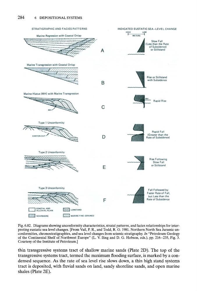
Fig. 6.82. Diagrams showing unconformity characteristics, stratal patterns, and facies relationships for interpreting eustatic sea level changes. [From Vail, P. R., and Todd, R. G. 1981. Northern North Sea Jurassic unconformities, chronostratigraphies, and sea level changes from seismic stratigraphy. In "Petroleum Geology
of the Continental Shelf of Northwest Europe" (L. V. Iling and D. G. Hobson, eds.), pp. 216-235, Fig. 3.
Courtesy of the Institute of Petroleum.]
thin transgressive systems tract of shallow marine sands (Plate 2D). The top of the
transgressive systems tract, termed the maximum flooding surface, is marked by a condensed sequence. As the rate of sea level rise slows down, a thin high stand systems
tract is deposited, with fluvial sands on land, sandy shoreline sands, and open marine
shales (Plate 2E).
6 DEPOSITIONAL SYSTEMS
Fig. 6.82. Diagrams showing unconformity characteristics, stratal patterns, and facies relationships for interpreting eustatic sea level changes. [From Vail, P. R., and Todd, R. G. 1981. Northern North Sea Jurassic unconformities, chronostratigraphies, and sea level changes from seismic stratigraphy. In "Petroleum Geology
of the Continental Shelf of Northwest Europe" (L. V. Iling and D. G. Hobson, eds.), pp. 216-235, Fig. 3.
Courtesy of the Institute of Petroleum.]
thin transgressive systems tract of shallow marine sands (Plate 2D). The top of the
transgressive systems tract, termed the maximum flooding surface, is marked by a condensed sequence. As the rate of sea level rise slows down, a thin high stand systems
tract is deposited, with fluvial sands on land, sandy shoreline sands, and open marine
shales (Plate 2E).